Randonnée Marche Kranjska Gora - kgora - Photo
 tosan
tosan

Utilisateur

© OpenStreetMap contributors
Longueur
Longueur
23 km
Altitude max
Altitude max
1577 m
Dénivelé positif
Dénivelé positif
1173 m
Km-Effort
Km-Effort  
39 km
Altitude min
Altitude min
772 m
Dénivelé négatif
Dénivelé négatif
1156 m
Boucle
Boucle
Non
Date de création :
2023-07-23 06:11:51.177
Dernière modification :
2023-07-23 15:49:35.521

(0 Avis)

Marche
Marche
8h52
Difficulté : Très difficile

Scannez ce code QR pour ouvrir la randonnée dans l'application SityTrail

Application GPS de randonnée GRATUITE

Logo SityTrail SityTrail

IGN / Instituts géographiques

Télécharger SityTrail sur l'App Store Télécharger SityTrail sur Google Play

Logo SityTrail SityTrail World

Le monde est à vous

Télécharger SityTrail sur l'App Store Télécharger SityTrail sur Google Play Télécharger SityTrail sur Huawei AppGallery

À propos

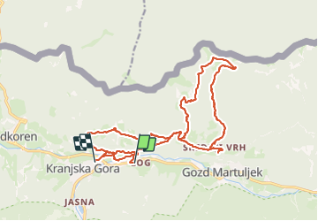
Randonnée Marche de 23 km à découvrir à Inconnu, Inconnu, Kranjska Gora. Cette randonnée est proposée par tosan.

Profil altimétrique

Localisation

Pays :
Slovénie
Région :
Inconnu
Département/Province :
Inconnu
Commune :
Kranjska Gora
Localité :
Unknown
Départ:(UTM)
408248 ; 5148817 (33T) N.

Randonnées à proximité

Randonnée Vélo Kranjska Gora - Kranjska Gora - Villach - Photo
Vélo
karawatsj

Vélo

Facile
Kranjska Gora, Inconnu, Inconnu, Slovénie
49 km | 57 km-effort
2h 58min
Non
Randonnée V.T.T. Kranjska Gora - TS 2021 - V Finale -Jour 2 variante - Photo
V.T.T.
vcoget

V.T.T.

Très difficile
Kranjska Gora, Inconnu, Inconnu, Slovénie
48 km | 66 km-effort
4h 33min
Non
Randonnée V.T.T. Kranjska Gora - TS 2021 - V Finale - Jour 2 - Photo
V.T.T.
vcoget

V.T.T.

Très difficile
Kranjska Gora, Inconnu, Inconnu, Slovénie
45 km | 65 km-effort
4h 31min
Non


Fermer
Mes abonnements