Randonnée Marche Saint-Laurent-en-Gâtines - Saint-Laurent-en-Gâtines - variante du PR Chemin de Chenusson - 10.2km 90m 2h25 - 2023 07 30 - Photo

Saint-Laurent-en-Gâtines - variante du PR Chemin de Chenusson - 10.2km 90m 2h25 - 2023 07 30

 Orcal37
Orcal37

Utilisateur

© OpenStreetMap contributors
Longueur
Longueur
10,3 km
Altitude max
Altitude max
171 m
Dénivelé positif
Dénivelé positif
92 m
Km-Effort
Km-Effort  
11,5 km
Altitude min
Altitude min
136 m
Dénivelé négatif
Dénivelé négatif
91 m
Boucle
Boucle
Oui
Date de création :
2023-07-30 13:11:54.206
Dernière modification :
2023-08-02 09:38:58.782

(0 Avis)

Marche
Marche
2h25
Difficulté : Facile

Scannez ce code QR pour ouvrir la randonnée dans l'application SityTrail

Application GPS de randonnée GRATUITE

Logo SityTrail SityTrail

IGN / Instituts géographiques

Télécharger SityTrail sur l'App Store Télécharger SityTrail sur Google Play

Logo SityTrail SityTrail World

Le monde est à vous

Télécharger SityTrail sur l'App Store Télécharger SityTrail sur Google Play Télécharger SityTrail sur Huawei AppGallery

À propos

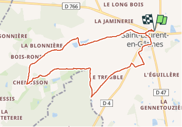
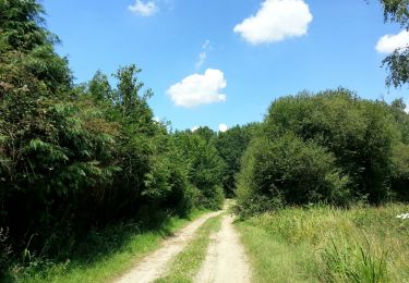
Randonnée Marche de 10,3 km à découvrir à Centre-Val de Loire, Indre-et-Loire, Saint-Laurent-en-Gâtines. Cette randonnée est proposée par Orcal37.

Description

Saint-Laurent-en-Gâtines - variante du PR Chemin de Chenusson - 10.2km 90m 2h25 - 2023 07 30

Profil altimétrique

Photos

Localisation

Pays :
France
Région :
Centre-Val de Loire
Département/Province :
Indre-et-Loire
Commune :
Saint-Laurent-en-Gâtines
Localité :
Unknown
Départ:(UTM)
333026 ; 5272851 (31T) N.

Randonnées à proximité

Randonnée Marche La Ferrière - la Ferrière - le Moulin à Vent à Saint-Laurent-en-Gâtines - 14.9km 115m 3h20 (30mn) - 2023 07 30 - Photo
Marche
Orcal37

Marche

Facile
La Ferrière, Centre-Val de Loire, Indre-et-Loire, France
14,9 km | 16,5 km-effort
3h 20min
Oui
Randonnée Marche Saint-Laurent-en-Gâtines - Saint-Laurent-en-Gatines - Photo
Marche
guydu41

Marche

Difficile
Saint-Laurent-en-Gâtines, Centre-Val de Loire, Indre-et-Loire, France
13,1 km | 14,9 km-effort
3h 23min
Oui
Randonnée Marche Villedômer - Villedômer - Photo
Marche
guydu41

Marche

Facile
Villedômer, Centre-Val de Loire, Indre-et-Loire, France
10,8 km | 12,8 km-effort
2h 54min
Oui
Randonnée Marche La Ferrière - La Ferrière - Photo
Marche
guydu41

Marche

Facile
La Ferrière, Centre-Val de Loire, Indre-et-Loire, France
10,6 km | 11,9 km-effort
2h 42min
Oui
Randonnée Marche Monthodon - Monthodon Le Sentier - Photo
Marche
guydu41

Marche

Moyen
Monthodon, Centre-Val de Loire, Indre-et-Loire, France
8,5 km | 9,5 km-effort
2h 9min
Oui
Randonnée Marche Saint-Laurent-en-Gâtines - Saint-Laurent-en-Gâtines - Circuit jaune avec variante le Sentier - 18.7km 120m 4h30 - 2022 05 01 - Photo
Marche
Orcal37

Marche

Facile
Saint-Laurent-en-Gâtines, Centre-Val de Loire, Indre-et-Loire, France
18,7 km | 20 km-effort
4h 30min
Oui
Randonnée Marche Nouzilly - Nouzilly - Circuit des Orchidées - 22.4km 375m 5h10 - 2022 04 10 - Photo
Marche
Orcal37

Marche

Moyen
Nouzilly, Centre-Val de Loire, Indre-et-Loire, France
22 km | 27 km-effort
5h 10min
Oui
Randonnée Marche Crotelles - Crotelles - PR avec variante - 21.4km 285m 4h35 (30mn) - 2021 03 20 - Photo
Marche
Orcal37

Marche

Facile
Crotelles, Centre-Val de Loire, Indre-et-Loire, France
21 km | 25 km-effort
4h 35min
Oui
Randonnée Marche Monthodon - Monthodon - circuits A travers champs et Les sentiers de la Glaise - 26.7km 230m 5h45 (35mn) - 2018 07 15 - Photo
Marche
Orcal37

Marche

Facile
Monthodon, Centre-Val de Loire, Indre-et-Loire, France
27 km | 30 km-effort
5h 45min
Oui


Fermer
Mes abonnements