Randonnée Autre activité Le Léman (VS) - bdr99_StGingolphe_Leysin - Photo

bdr99_StGingolphe_Leysin

Optez pour le retour à la nature GUIDE+

© OpenStreetMap contributors
Longueur
Longueur
26 km
Altitude max
Altitude max
1333 m
Dénivelé positif
Dénivelé positif
1174 m
Km-Effort
Km-Effort  
38 km
Altitude min
Altitude min
370 m
Dénivelé négatif
Dénivelé négatif
255 m
Boucle
Boucle
Non
Date de création :
2014-12-10 00:00:00.0
Dernière modification :
2014-12-10 00:00:00.0

(0 Avis)

Autre activité
Autre activité
8h59
Difficulté : Inconnu

Scannez ce code QR pour ouvrir la randonnée dans l'application SityTrail

Application GPS de randonnée GRATUITE

Logo SityTrail SityTrail

IGN / Instituts géographiques

Télécharger SityTrail sur l'App Store Télécharger SityTrail sur Google Play

Logo SityTrail SityTrail World

Le monde est à vous

Télécharger SityTrail sur l'App Store Télécharger SityTrail sur Google Play Télécharger SityTrail sur Huawei AppGallery

À propos

Randonnée Autre activité de 26 km à découvrir à Valais, Monthey, Le Léman (VS). Cette randonnée est proposée par My Switzerland.

Profil altimétrique

Localisation

Pays :
Suisse
Région :
Valais
Département/Province :
Monthey
Commune :
Le Léman (VS)
Localité :
Unknown
Départ:(Dec)
Départ:(UTM)
331279 ; 5140187 (32T) N.

Randonnées à proximité

Randonnée V.T.T. Saint-Gingolph - TransAlpes VTT - 01/25 - St Gingolf - Lac de Tanay - Photo
V.T.T.
tracegps

V.T.T.

Difficile
Saint-Gingolph, Valais, Monthey, Suisse
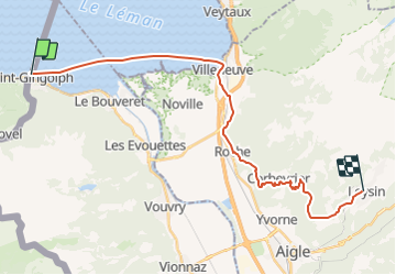
13,8 km | 27 km-effort
2h 30min
Non
Randonnée Marche Thollon-les-Mémises - 15 juillet - Photo
Marche
Huangdi

Marche

Très facile
Thollon-les-Mémises, Auvergne-Rhône-Alpes, Haute-Savoie, France
10,8 km | 26 km-effort
4h 27min
Non
Randonnée Autre activité Saint-Gingolph - bdx001_0623 - Photo
Autre activité
GUIDE+

Autre activité

Très facile
Saint-Gingolph, Valais, Monthey, Suisse
11,3 km | 35 km-effort
8h 5min
Non
Randonnée Autre activité Saint-Gingolph - ST_harlin_test - Photo
Autre activité
GUIDE+

Autre activité

Très facile
Saint-Gingolph, Auvergne-Rhône-Alpes, Haute-Savoie, France
32 km | 84 km-effort
14h 44min
Non
Randonnée Autre activité Le Léman (VS) - bdr01_StGingolphe_Trient - Photo
Autre activité
GUIDE+

Autre activité

Très facile
Le Léman (VS), Valais, Monthey, Suisse
68 km | 170 km-effort
40h 54min
Non
Randonnée Autre activité Saint-Gingolph - xxx20_Heremence_StGingolphe - Photo
Autre activité
GUIDE+

Autre activité

Très facile
Saint-Gingolph, Valais, Monthey, Suisse
59 km | 59 km-effort
13h 24min
Non
Randonnée Marche Novel - Novel -Col de Neuva et Pic Boré - Photo
Marche
marcel.F

Marche

Très difficile
Novel, Auvergne-Rhône-Alpes, Haute-Savoie, France
10,3 km | 20 km-effort
4h 37min
Oui
Randonnée sport Saint-Gingolph - Etape1 St Gingolph-Refuge Chalets de Bise - Photo
sport
anne.legrand

sport

Très facile
Saint-Gingolph, Valais, Monthey, Suisse
11,2 km | 28 km-effort
Inconnu
Non
Randonnée Vélo de route Port-Valais - st ginghof le Bouveret, /messery  - Photo
Vélo de route
levequejef

Vélo de route

Très facile
Port-Valais, Valais, Monthey, Suisse
60 km | 69 km-effort
6h 37min
Non


Fermer
Mes abonnements