![](/images/other/stat-length.png)
![Randonnée Marche Marchin - Les cathédrales de Marchin - Photo](https://media.geolcdn.com/t/1900/400/ext.pjpeg?maxdim=2&url=https%3A%2F%2Fmedia.geolcdn.com%2Ff%2Fb3aa3b84-2d94-4cb9-8844-eb9c0cdce6a3.jpg)
Les cathédrales de Marchin
Thierry0032
Utilisateur
![Longueur](/images/other/stat-length.png)
Longueur
5,5 km
![Altitude max](https://static1.geolcdn.com/siteimages/upload/files/1508320355ic_sort_altitude_max_24dp.png)
Altitude max
270 m
![Dénivelé positif](https://static1.geolcdn.com/siteimages/upload/files/1508320355ic_sort_den_pos_24dp.png)
Dénivelé positif
93 m
![Km-Effort](/images/other/stat-length.png)
Km-Effort
6,7 km
![Altitude min](https://static1.geolcdn.com/siteimages/upload/files/1508320355ic_sort_altitude_min_24dp.png)
Altitude min
197 m
![Dénivelé négatif](https://static1.geolcdn.com/siteimages/upload/files/1508320355ic_sort_den_neg_24dp.png)
Dénivelé négatif
93 m
![Boucle](https://static1.geolcdn.com/siteimages/upload/files/16400158638029165_repeat_loop_refresh_sync_direction_icon.png)
Boucle
Oui
Date de création :
2023-11-01 13:54:02.304
Dernière modification :
2023-11-04 11:01:21.259
![Marche](https://static1.geolcdn.com/sitytour/trail-icons/101.png)
1h48
Difficulté : Moyen
![Scannez ce code QR pour ouvrir la randonnée dans l'application SityTrail](https://capi.geolives.com/qq0zvz2zws4bq2lad0pu/sitytour/trails/3858180/qr.png?size=200)
Application GPS de randonnée GRATUITE
À propos
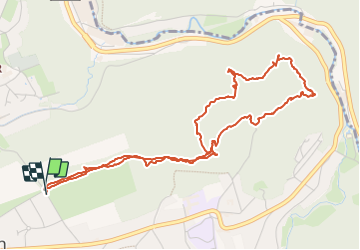
Randonnée Marche de 5,5 km à découvrir à Wallonie, Liège, Marchin. Cette randonnée est proposée par Thierry0032.
Description
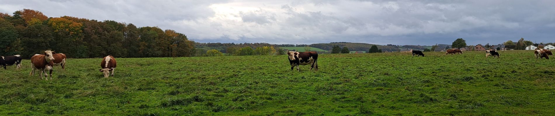
Prévoir des bonnes chaussures, surtout par temps humide. Arrivé au cathédrale, il est conseillé de continuer le chemin plutôt que de couper par le dessus des cathédrales.
Localisation
Pays :
Belgique
Région :
Wallonie
Département/Province :
Liège
Commune :
Marchin
Localité :
Unknown
Départ:(Dec)
Départ:(UTM)
658371 ; 5594735 (31U) N.
Commentaires
Randonnées à proximité
![Randonnée Marche Huy - Huy Ben-Ahin. Natura 2000 des sites qui valent le détour ! Lg9 - Photo](https://media.geolcdn.com/t/375/260/ext.jpg?maxdim=2&url=https%3A%2F%2Fservices.sitytrail.com%2FGeolivesWS%2FDownloadMedia.ashx%3FTrailID%3D182987%26Media%3Da8459ff4-9180-431b-88aa-1e326f78de1f.JPG)
![Marche Marche](https://static1.geolcdn.com/sitytour/trail-icons/101.png)
Huy Ben-Ahin. Natura 2000 des sites qui valent le détour ! Lg9
Marche
Moyen
(15)
Huy,
Wallonie,
Liège,
Belgique
![](/images/other/stat-length.png)
7,9 km | 10,7 km-effort
2h 18min
![](https://static1.geolcdn.com/siteimages/upload/files/16400158638029165_repeat_loop_refresh_sync_direction_icon.png)
Non
![Randonnée Marche Modave - Modave. Natura 2000, des sites qui valent le détour ! Lg4 - Photo](https://media.geolcdn.com/t/375/260/ext.jpg?maxdim=2&url=https%3A%2F%2Fservices.sitytrail.com%2FGeolivesWS%2FDownloadMedia.ashx%3FTrailID%3D161410%26Media%3Dd7c559bb-fafd-4624-b5f1-8908c3c540dc.JPG)
![Marche Marche](https://static1.geolcdn.com/sitytour/trail-icons/101.png)
Modave. Natura 2000, des sites qui valent le détour ! Lg4
Marche
Moyen
(12)
Modave,
Wallonie,
Liège,
Belgique
![](/images/other/stat-length.png)
8,2 km | 10,1 km-effort
2h 12min
![](https://static1.geolcdn.com/siteimages/upload/files/16400158638029165_repeat_loop_refresh_sync_direction_icon.png)
Oui
![Randonnée Marche Marchin - MARCHIN - Chemin de la Mémoire - Photo](https://media.geolcdn.com/t/375/260/ext.jpg?maxdim=2&url=https%3A%2F%2Fservices.sitytrail.com%2FGeolivesWS%2FDownloadMedia.ashx%3FTrailID%3D134945%26Media%3D9baec6a8-ffff-4223-8cd2-41c1e7b6afda.jpg)
![Marche Marche](https://static1.geolcdn.com/sitytour/trail-icons/101.png)
MARCHIN - Chemin de la Mémoire
Marche
Moyen
(5)
Marchin,
Wallonie,
Liège,
Belgique
![](/images/other/stat-length.png)
9 km | 11 km-effort
2h 15min
![](https://static1.geolcdn.com/siteimages/upload/files/16400158638029165_repeat_loop_refresh_sync_direction_icon.png)
Oui
![Randonnée Marche Modave - MODAVE - Petit Modave - Photo](https://media.geolcdn.com/t/375/260/ext.jpg?maxdim=2&url=https%3A%2F%2Fservices.sitytrail.com%2FGeolivesWS%2FDownloadMedia.ashx%3FTrailID%3D211950%26Media%3D225bb37c-a1e6-4f9b-b5fa-27b4f60e72ba.JPG)
![Marche Marche](https://static1.geolcdn.com/sitytour/trail-icons/101.png)
MODAVE - Petit Modave
Marche
Moyen
(19)
Modave,
Wallonie,
Liège,
Belgique
![](/images/other/stat-length.png)
7,6 km | 9,4 km-effort
2h 0min
![](https://static1.geolcdn.com/siteimages/upload/files/16400158638029165_repeat_loop_refresh_sync_direction_icon.png)
Oui
![Randonnée Marche Modave - Balade à Modave - Photo](https://media.geolcdn.com/t/375/260/ext.jpg?maxdim=2&url=https%3A%2F%2Fmedia.geolcdn.com%2Ff%2Fefa446e4-aa4c-4b7a-afaa-1e1b5351db79.jpeg)
![Marche Marche](https://static1.geolcdn.com/sitytour/trail-icons/101.png)
Balade à Modave
Marche
Très facile
(2)
Modave,
Wallonie,
Liège,
Belgique
![](/images/other/stat-length.png)
8,9 km | 10,9 km-effort
3h 40min
![](https://static1.geolcdn.com/siteimages/upload/files/16400158638029165_repeat_loop_refresh_sync_direction_icon.png)
Oui
![Randonnée Marche Ohey - Sentiers d'Art : Boucle 13 - Jallet - Photo](https://media.geolcdn.com/t/375/260/ext.jpg?maxdim=2&url=https%3A%2F%2Fmedia.geolcdn.com%2Ff%2Fa759f816-4e45-4141-b3b0-3fdc8cbc0aa1.JPG)
![Marche Marche](https://static1.geolcdn.com/sitytour/trail-icons/101.png)
Sentiers d'Art : Boucle 13 - Jallet
Marche
Difficile
(4)
Ohey,
Wallonie,
Namur,
Belgique
![](/images/other/stat-length.png)
11,9 km | 14,3 km-effort
3h 15min
![](https://static1.geolcdn.com/siteimages/upload/files/16400158638029165_repeat_loop_refresh_sync_direction_icon.png)
Oui
![Randonnée Marche Marchin - Chasse au trésor](https://media.geolcdn.com/t/375/260/ext.jpg?maxdim=2&url=https%3A%2F%2Fmedia.geolcdn.com%2Ff%2F9cfc469f-0f94-4339-a9dc-cdaec56a9342.JPG)
![Marche Marche](https://static1.geolcdn.com/sitytour/trail-icons/101.png)
Chasse au trésor "Le paysan de Jamagne dupe le diable"
Marche
Facile
(1)
Marchin,
Wallonie,
Liège,
Belgique
![](/images/other/stat-length.png)
6,1 km | 7,8 km-effort
1h 40min
![](https://static1.geolcdn.com/siteimages/upload/files/16400158638029165_repeat_loop_refresh_sync_direction_icon.png)
Oui
![Randonnée Marche Huy - TIHANGE (Temple Tibétain). - Photo](https://media.geolcdn.com/t/375/260/ext.jpg?maxdim=2&url=https%3A%2F%2Fservices.sitytrail.com%2FGeolivesWS%2FDownloadMedia.ashx%3FTrailID%3D458488%26Media%3Dfix__20150813122829.jpg)
![Marche Marche](https://static1.geolcdn.com/sitytour/trail-icons/101.png)
TIHANGE (Temple Tibétain).
Marche
Très facile
(2)
Huy,
Wallonie,
Liège,
Belgique
![](/images/other/stat-length.png)
11,5 km | 13,9 km-effort
3h 1min
![](https://static1.geolcdn.com/siteimages/upload/files/16400158638029165_repeat_loop_refresh_sync_direction_icon.png)
Oui
![Randonnée Marche Ohey - Goesnes et Hodoumont - Photo](https://media.geolcdn.com/t/375/260/ext.jpg?maxdim=2&url=https%3A%2F%2Fstatic1.geolcdn.com%2Fsiteimages%2Fupload%2Ffiles%2F1553511878bg_sport_marche.png)
![Marche Marche](https://static1.geolcdn.com/sitytour/trail-icons/101.png)
Goesnes et Hodoumont
Marche
Facile
(3)
Ohey,
Wallonie,
Namur,
Belgique
![](/images/other/stat-length.png)
8,6 km | 10,3 km-effort
2h 15min
![](https://static1.geolcdn.com/siteimages/upload/files/16400158638029165_repeat_loop_refresh_sync_direction_icon.png)
Oui