![](/images/other/stat-length.png)
![Randonnée Marche Malines - S-GR Dijleland : Muizen - Mechelen - Eppegem - Photo](https://media.geolcdn.com/t/1900/400/ext.pjpeg?maxdim=2&url=https%3A%2F%2Fmedia.geolcdn.com%2Ff%2Fbf0307c6-7818-44b7-a71f-d4ed30d79703.jpeg)
S-GR Dijleland : Muizen - Mechelen - Eppegem
dauzata
Utilisateur
![Longueur](/images/other/stat-length.png)
Longueur
21 km
![Altitude max](https://static1.geolcdn.com/siteimages/upload/files/1508320355ic_sort_altitude_max_24dp.png)
Altitude max
23 m
![Dénivelé positif](https://static1.geolcdn.com/siteimages/upload/files/1508320355ic_sort_den_pos_24dp.png)
Dénivelé positif
141 m
![Km-Effort](/images/other/stat-length.png)
Km-Effort
23 km
![Altitude min](https://static1.geolcdn.com/siteimages/upload/files/1508320355ic_sort_altitude_min_24dp.png)
Altitude min
-5 m
![Dénivelé négatif](https://static1.geolcdn.com/siteimages/upload/files/1508320355ic_sort_den_neg_24dp.png)
Dénivelé négatif
140 m
![Boucle](https://static1.geolcdn.com/siteimages/upload/files/16400158638029165_repeat_loop_refresh_sync_direction_icon.png)
Boucle
Non
Date de création :
2023-11-19 09:40:39.0
Dernière modification :
2023-11-19 20:28:42.35
![Marche](https://static1.geolcdn.com/sitytour/trail-icons/101.png)
5h18
Difficulté : Moyen
![Scannez ce code QR pour ouvrir la randonnée dans l'application SityTrail](https://capi.geolives.com/qq0zvz2zws4bq2lad0pu/sitytour/trails/3871179/qr.png?size=200)
Application GPS de randonnée GRATUITE
À propos
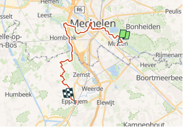
Randonnée Marche de 21 km à découvrir à Flandre, Anvers, Malines. Cette randonnée est proposée par dauzata.
Description
Départ: Gare de Muizen
Arrivée: Gare de Eppegem
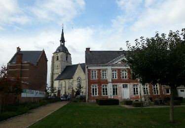
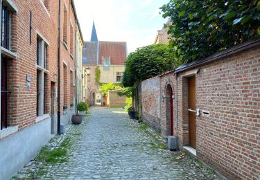
Détour par la cathédrale Saint-Rombaut dans Mechelen ( 1 km)
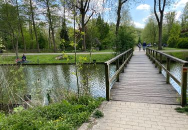
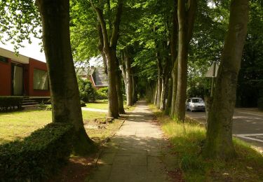
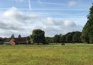
Localisation
Pays :
Belgique
Région :
Flandre
Département/Province :
Anvers
Commune :
Malines
Localité :
Unknown
Départ:(Dec)
Départ:(UTM)
606214 ; 5651863 (31U) N.
Commentaires
Randonnées à proximité
![Randonnée Marche Bonheiden - Hever - Photo](https://media.geolcdn.com/t/375/260/ext.jpg?maxdim=2&url=https%3A%2F%2Fservices.sitytrail.com%2FGeolivesWS%2FDownloadMedia.ashx%3FTrailID%3D656803%26Media%3Dfix__20161020152445.jpg)
![Marche Marche](https://static1.geolcdn.com/sitytour/trail-icons/101.png)
![Randonnée Marche Malines - Mechels Broek - Photo](https://media.geolcdn.com/t/375/260/ext.jpg?maxdim=2&url=https%3A%2F%2Fmedia.geolcdn.com%2Ff%2F9bcb37dd-3951-4aca-95ae-228b9c6b487f.jpg)
![Marche Marche](https://static1.geolcdn.com/sitytour/trail-icons/101.png)
![Randonnée A pied Malines - Mechels Broek A. S. Adventureroute - Photo](https://media.geolcdn.com/t/375/260/ext.jpg?maxdim=2&url=https%3A%2F%2Fmedia.geolcdn.com%2Ff%2F93d6dbbd-a75f-4ec7-9bd1-e2b544fc0532.jpeg)
![A pied A pied](https://static1.geolcdn.com/sitytour/trail-icons/100.png)
Mechels Broek A. S. Adventureroute
A pied
Facile
Malines,
Flandre,
Anvers,
Belgique
![](/images/other/stat-length.png)
5,8 km | 6,2 km-effort
1h 24min
![](https://static1.geolcdn.com/siteimages/upload/files/16400158638029165_repeat_loop_refresh_sync_direction_icon.png)
Oui
![Randonnée Marche Zemst - Weerde Eppegem Zemst - 8 km RT - Photo](https://media.geolcdn.com/t/375/260/ext.jpg?maxdim=2&url=https%3A%2F%2Fstatic1.geolcdn.com%2Fsiteimages%2Fupload%2Ffiles%2F1553511878bg_sport_marche.png)
![Marche Marche](https://static1.geolcdn.com/sitytour/trail-icons/101.png)
Weerde Eppegem Zemst - 8 km RT
Marche
Très facile
(1)
Zemst,
Flandre,
Brabant flamand,
Belgique
![](/images/other/stat-length.png)
8,2 km | 8,7 km-effort
Inconnu
![](https://static1.geolcdn.com/siteimages/upload/files/16400158638029165_repeat_loop_refresh_sync_direction_icon.png)
Oui
![Randonnée Marche Malines - Malines ouest 18,3 km - Photo](https://media.geolcdn.com/t/375/260/ext.jpg?maxdim=2&url=https%3A%2F%2Fmedia.geolcdn.com%2Ff%2F9f492b71-0eb3-460c-aa58-29536b7e1526.jpg)
![Marche Marche](https://static1.geolcdn.com/sitytour/trail-icons/101.png)
Malines ouest 18,3 km
Marche
Facile
(1)
Malines,
Flandre,
Anvers,
Belgique
![](/images/other/stat-length.png)
18,4 km | 19,6 km-effort
5h 29min
![](https://static1.geolcdn.com/siteimages/upload/files/16400158638029165_repeat_loop_refresh_sync_direction_icon.png)
Oui
![Randonnée A pied Zemst - 5 km looproute - Photo](https://media.geolcdn.com/t/375/260/ext.jpg?maxdim=2&url=https%3A%2F%2Fmedia.geolcdn.com%2Ff%2F5bf54057-1682-421e-b778-f05b4be0d342.jpeg)
![A pied A pied](https://static1.geolcdn.com/sitytour/trail-icons/100.png)
5 km looproute
A pied
Facile
Zemst,
Flandre,
Brabant flamand,
Belgique
![](/images/other/stat-length.png)
5 km | 5,5 km-effort
1h 15min
![](https://static1.geolcdn.com/siteimages/upload/files/16400158638029165_repeat_loop_refresh_sync_direction_icon.png)
Oui
![Randonnée A pied Zemst - Weerdse Kronkels - Photo](https://media.geolcdn.com/t/375/260/ext.jpg?maxdim=2&url=https%3A%2F%2Fmedia.geolcdn.com%2Ff%2F1a8287f3-ddc8-4a38-9508-75b884259afe.jpeg)
![A pied A pied](https://static1.geolcdn.com/sitytour/trail-icons/100.png)
Weerdse Kronkels
A pied
Facile
Zemst,
Flandre,
Brabant flamand,
Belgique
![](/images/other/stat-length.png)
7,6 km | 8,1 km-effort
1h 50min
![](https://static1.geolcdn.com/siteimages/upload/files/16400158638029165_repeat_loop_refresh_sync_direction_icon.png)
Oui
![Randonnée Marche Malines - Malines out and in 20 km - Photo](https://media.geolcdn.com/t/375/260/ext.jpg?maxdim=2&url=https%3A%2F%2Fmedia.geolcdn.com%2Ff%2Ffeebb084-0339-4f27-8695-b58d3cb5a801.jpg)
![Marche Marche](https://static1.geolcdn.com/sitytour/trail-icons/101.png)
Malines out and in 20 km
Marche
Facile
Malines,
Flandre,
Anvers,
Belgique
![](/images/other/stat-length.png)
21 km | 23 km-effort
6h 31min
![](https://static1.geolcdn.com/siteimages/upload/files/16400158638029165_repeat_loop_refresh_sync_direction_icon.png)
Oui
![Randonnée Marche Bonheiden - Malines les marais moeras 21 km - Photo](https://media.geolcdn.com/t/375/260/ext.jpg?maxdim=2&url=https%3A%2F%2Fmedia.geolcdn.com%2Ff%2Fcdb70a8a-04c8-4736-88ef-c7450fb13e45.jpg)
![Marche Marche](https://static1.geolcdn.com/sitytour/trail-icons/101.png)
Malines les marais moeras 21 km
Marche
Bonheiden,
Flandre,
Anvers,
Belgique
![](/images/other/stat-length.png)
22 km | 24 km-effort
5h 16min
![](https://static1.geolcdn.com/siteimages/upload/files/16400158638029165_repeat_loop_refresh_sync_direction_icon.png)
Oui