![](/images/other/stat-length.png)
#240315 - Ohain Golf de Waterloo Marache****
Randos Ouvertes
Utilisateur
![Longueur](/images/other/stat-length.png)
![Altitude max](https://static1.geolcdn.com/siteimages/upload/files/1508320355ic_sort_altitude_max_24dp.png)
![Dénivelé positif](https://static1.geolcdn.com/siteimages/upload/files/1508320355ic_sort_den_pos_24dp.png)
![Km-Effort](/images/other/stat-length.png)
![Altitude min](https://static1.geolcdn.com/siteimages/upload/files/1508320355ic_sort_altitude_min_24dp.png)
![Dénivelé négatif](https://static1.geolcdn.com/siteimages/upload/files/1508320355ic_sort_den_neg_24dp.png)
![Boucle](https://static1.geolcdn.com/siteimages/upload/files/16400158638029165_repeat_loop_refresh_sync_direction_icon.png)
![Marche](https://static1.geolcdn.com/sitytour/trail-icons/101.png)
1h41
Difficulté : Moyen
![Scannez ce code QR pour ouvrir la randonnée dans l'application SityTrail](https://capi.geolives.com/qq0zvz2zws4bq2lad0pu/sitytour/trails/3981175/qr.png?size=200)
Application GPS de randonnée GRATUITE
À propos
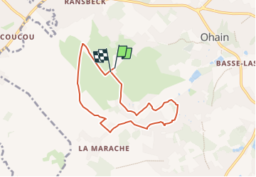
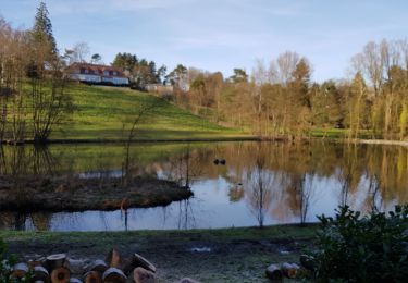
Randonnée Marche de 6,3 km à découvrir à Wallonie, Brabant wallon, Lasne. Cette randonnée est proposée par Randos Ouvertes.
Description
Boucle à partir du Parking du Sport Village
Vieux Chemin de Wavre 117
1380 Ohain, Belgique
Magnifique circuit de 6,3 km et 90 m de dénivelé.
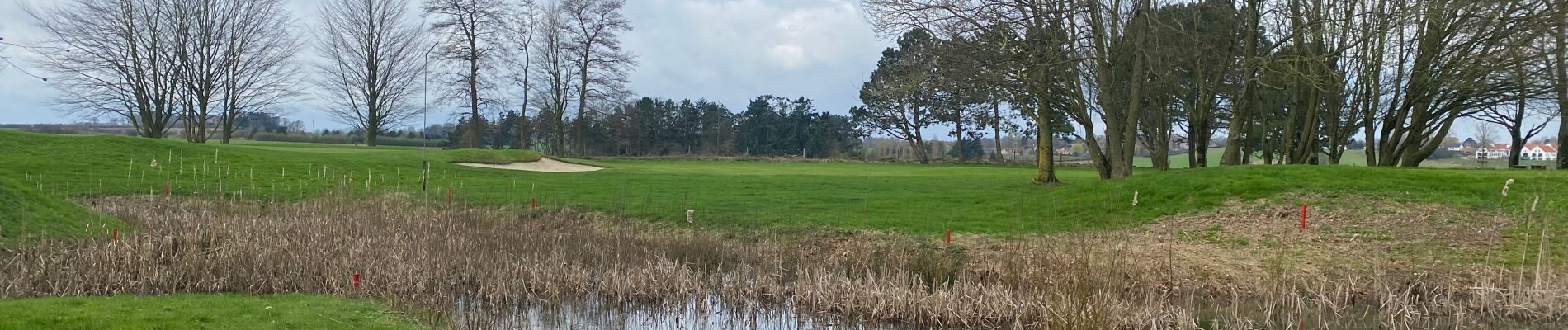
Traversée d'une partie du golf par servitude ouverte au public.
Grandes étendues typiques de la morne plaine.
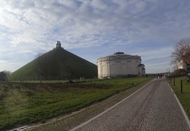
On aperçoit le Lion de Waterloo au loin.
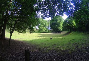
Petit sentier pittoresque longeant le Smohain.
Crédits photos : Béatrice Walsdorff, Sophie Vermote et Corinne van Aubel - Randos Ouvertes 2024
Localisation
Commentaires
Randonnées à proximité
![Randonnée Marche Lasne - RB-Bw-11_Lasne_via-racc-2 - Photo](https://media.geolcdn.com/t/375/260/ext.jpg?maxdim=2&url=https%3A%2F%2Fservices.sitytrail.com%2FGeolivesWS%2FDownloadMedia.ashx%3FTrailID%3D220382%26Media%3De3749982-4581-4663-b0ab-732ada3b6d18.jpg)
![Marche Marche](https://static1.geolcdn.com/sitytour/trail-icons/101.png)
Marche
![](/images/other/stat-length.png)
![](https://static1.geolcdn.com/siteimages/upload/files/16400158638029165_repeat_loop_refresh_sync_direction_icon.png)
![Randonnée Marche Lasne - RB-Bw-11_Lasne_via-racc-1 - Photo](https://media.geolcdn.com/t/375/260/ext.jpg?maxdim=2&url=https%3A%2F%2Fservices.sitytrail.com%2FGeolivesWS%2FDownloadMedia.ashx%3FTrailID%3D220381%26Media%3Dc424c810-e3fc-4417-9a3b-ca0a22b722e1.jpg)
![Marche Marche](https://static1.geolcdn.com/sitytour/trail-icons/101.png)
Marche
![](/images/other/stat-length.png)
![](https://static1.geolcdn.com/siteimages/upload/files/16400158638029165_repeat_loop_refresh_sync_direction_icon.png)
![Randonnée Marche Lasne - RB-Bw-11_Lasne - Photo](https://media.geolcdn.com/t/375/260/ext.jpg?maxdim=2&url=https%3A%2F%2Fservices.sitytrail.com%2FGeolivesWS%2FDownloadMedia.ashx%3FTrailID%3D179586%26Media%3Dc424c810-e3fc-4417-9a3b-ca0a22b722e1.jpg)
![Marche Marche](https://static1.geolcdn.com/sitytour/trail-icons/101.png)
Marche
![](/images/other/stat-length.png)
![](https://static1.geolcdn.com/siteimages/upload/files/16400158638029165_repeat_loop_refresh_sync_direction_icon.png)
![Randonnée V.T.T. Braine-l'Alleud - O2bikers_58_Waterloo - Photo](https://media.geolcdn.com/t/375/260/ext.jpg?maxdim=2&url=https%3A%2F%2Fstatic1.geolcdn.com%2Fsiteimages%2Fupload%2Ffiles%2F1524743154velo.jpg)
![V.T.T. V.T.T.](https://static1.geolcdn.com/sitytour/trail-icons/202.png)
V.T.T.
![](/images/other/stat-length.png)
![](https://static1.geolcdn.com/siteimages/upload/files/16400158638029165_repeat_loop_refresh_sync_direction_icon.png)
![Randonnée V.T.T. Lasne - VTT de Maransart à la forêt de soigne - Photo](https://media.geolcdn.com/t/375/260/ext.jpg?maxdim=2&url=https%3A%2F%2Fmedia.geolcdn.com%2Ff%2F7952ab46-ca6a-430d-9a36-3ac3fa120ed7.JPG)
![V.T.T. V.T.T.](https://static1.geolcdn.com/sitytour/trail-icons/202.png)
V.T.T.
![](/images/other/stat-length.png)
![](https://static1.geolcdn.com/siteimages/upload/files/16400158638029165_repeat_loop_refresh_sync_direction_icon.png)
![Randonnée V.T.T. Lasne - VTT a plancenoit - Photo](https://media.geolcdn.com/t/375/260/ext.jpg?maxdim=2&url=https%3A%2F%2Fmedia.geolcdn.com%2Ff%2F76d1e3a8-2327-4878-9e20-19f4bddbc97f.JPG)
![V.T.T. V.T.T.](https://static1.geolcdn.com/sitytour/trail-icons/202.png)
V.T.T.
![](/images/other/stat-length.png)
![](https://static1.geolcdn.com/siteimages/upload/files/16400158638029165_repeat_loop_refresh_sync_direction_icon.png)
![Randonnée V.T.T. Waterloo - De Waterloo à la forêt de Soignes - Photo](https://media.geolcdn.com/t/375/260/ext.jpg?maxdim=2&url=https%3A%2F%2Fservices.sitytrail.com%2FGeolivesWS%2FDownloadMedia.ashx%3FTrailID%3D688453%26Media%3D31ac41f9-68d5-4a4a-9a8e-a882e9787769.JPG)
![V.T.T. V.T.T.](https://static1.geolcdn.com/sitytour/trail-icons/202.png)
V.T.T.
![](/images/other/stat-length.png)
![](https://static1.geolcdn.com/siteimages/upload/files/16400158638029165_repeat_loop_refresh_sync_direction_icon.png)
![Randonnée Marche La Hulpe - La Hulpe - Circuit Natura 2000, des sites qui valent le détour - Bw02 - Photo](https://media.geolcdn.com/t/375/260/ext.jpg?maxdim=2&url=https%3A%2F%2Fmedia.geolcdn.com%2Ff%2F7fa79586-43de-4fc0-89c7-4bc45138438a.jpg)
![Marche Marche](https://static1.geolcdn.com/sitytour/trail-icons/101.png)
Marche
![](/images/other/stat-length.png)
![](https://static1.geolcdn.com/siteimages/upload/files/16400158638029165_repeat_loop_refresh_sync_direction_icon.png)
![Randonnée Marche La Hulpe - Genval 0222 - Photo](https://media.geolcdn.com/t/375/260/ext.jpg?maxdim=2&url=https%3A%2F%2Fmedia.geolcdn.com%2Ff%2Fce137dda-b7be-44e8-80c8-fd5c067d3d98.jpg)
![Marche Marche](https://static1.geolcdn.com/sitytour/trail-icons/101.png)
Marche
![](/images/other/stat-length.png)
![](https://static1.geolcdn.com/siteimages/upload/files/16400158638029165_repeat_loop_refresh_sync_direction_icon.png)
et