![](/images/other/stat-length.png)
![Randonnée Marche Durbuy - RF-Lu-02 - Variante Ravel - Au fils de l'Ourthe : Barvaux - Photo](https://media.geolcdn.com/t/1900/400/ext.pjpeg?maxdim=2&url=https%3A%2F%2Fstatic1.geolcdn.com%2Fsiteimages%2Fupload%2Ffiles%2F1553511878bg_sport_marche.png)
RF-Lu-02 - Variante Ravel - Au fils de l'Ourthe : Barvaux
GR Rando
Randonnez sur et autour des GR ® wallons (Sentiers de Grande Randonnée). PRO
![Longueur](/images/other/stat-length.png)
![Altitude max](https://static1.geolcdn.com/siteimages/upload/files/1508320355ic_sort_altitude_max_24dp.png)
![Dénivelé positif](https://static1.geolcdn.com/siteimages/upload/files/1508320355ic_sort_den_pos_24dp.png)
![Km-Effort](/images/other/stat-length.png)
![Altitude min](https://static1.geolcdn.com/siteimages/upload/files/1508320355ic_sort_altitude_min_24dp.png)
![Dénivelé négatif](https://static1.geolcdn.com/siteimages/upload/files/1508320355ic_sort_den_neg_24dp.png)
![Boucle](https://static1.geolcdn.com/siteimages/upload/files/16400158638029165_repeat_loop_refresh_sync_direction_icon.png)
![Marche](https://static1.geolcdn.com/sitytour/trail-icons/101.png)
2h45
Difficulté : Inconnu
![Scannez ce code QR pour ouvrir la randonnée dans l'application SityTrail](https://capi.geolives.com/qq0zvz2zws4bq2lad0pu/sitytour/trails/415632/qr.png?size=200)
Application GPS de randonnée GRATUITE
À propos
Randonnée Marche de 10,5 km à découvrir à Wallonie, Luxembourg, Durbuy. Cette randonnée est proposée par GR Rando.
Description
Variante Ravel - Au fil de l'Ourthe : Barvaux
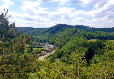
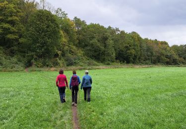
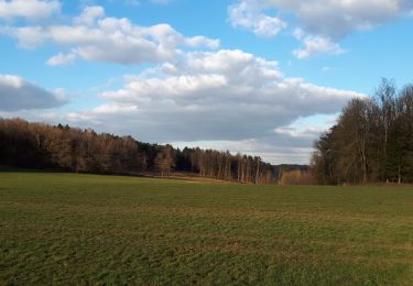
Dans quel type de paysage randonnons-nous ?
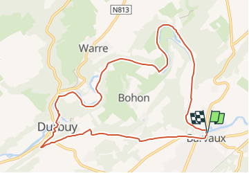
La plus grande partie de cette rando va se dérouler, soit en suivant la berge de l’Ourthe, dans le fond de la vallée donc, soit en la surplombant, via Warre et Durbuy. Puis ce sera la redescente jusqu’à Barvaux.
Où démarrons-nous ?
Au parking en bordure de l’Ourthe, non loin de l’église de Barvaux (carte Michelin n° 534, pli R/20).
Comment y arriver ?
À Barvaux, sur la N86, prendre, en face de l’église, la rue qui traverse l’Ourthe (en direction de « Hamoir - Tohogne »). À l’entrée de cette rue, à droite, se trouve ce grand parking.
Combien de kilomètres ?
10 km. Aucun raccourci n’est prévu.
Quelle difficulté ?
Aucune. À la sortie de Durbuy, un sentier en escaliers est un peu ardu.
Sur quel GR randonnons-nous ?
Pendant plus de 7 kilomètres, nous confierons nos pas au GR 57 (« Vallée de l’Ourthe et sentier du Nord »).
Quelle est la carte IGN de référence ?
Cartes IGN au 1:20 000, 55/1-2 « Durbuy - Érezée » et 49/5-6 « Hamoir - Ferrières ».
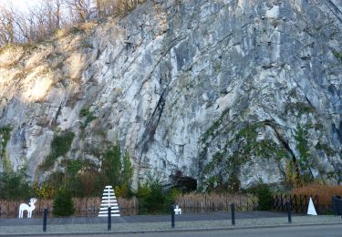
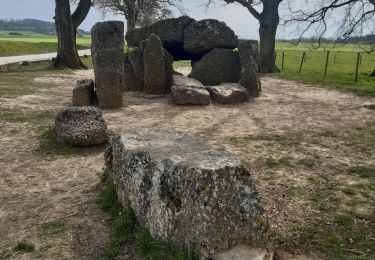
Que découvrons-nous aujourd’hui ?
Chaque été, sur plus de onze hectares, un nouveau dédale est conçu dans le « Labyrinthe de Barvaux ». Nous essayerons de ne pas perdre le nord dans toutes ses allées. À Durbuy, nous pourrons admirer le travail des sculpteurs de buis dans le « Jardin des Topiaires ». Et pour conclure cette belle journée, une descente en kayak vous tenterait peut-être ?
Transports en commun ?
La gare de Barvaux, à 500 mètres de l’église, est située sur la ligne 43 Herstal - Jemelle. En semaine, un train s’y arrête, dans chaque sens, toutes les heures. Les jours fériés et le week-end, seulement toutes les deux heures.
Localisation
Commentaires
Randonnées à proximité
![Randonnée Marche Durbuy - RB-Lu-01_Tohogne - Photo](https://media.geolcdn.com/t/375/260/ext.jpg?maxdim=2&url=https%3A%2F%2Fservices.sitytrail.com%2FGeolivesWS%2FDownloadMedia.ashx%3FTrailID%3D179610%26Media%3Dbae66ec4-955f-4295-8f2d-e1b21fcea213.jpg)
![Marche Marche](https://static1.geolcdn.com/sitytour/trail-icons/101.png)
Marche
![](/images/other/stat-length.png)
![](https://static1.geolcdn.com/siteimages/upload/files/16400158638029165_repeat_loop_refresh_sync_direction_icon.png)
![Randonnée Marche Durbuy - RF-Lu-01 - De dolmens en menhirs autour de Wéris - Photo](https://media.geolcdn.com/t/375/260/ext.jpg?maxdim=2&url=https%3A%2F%2Fstatic1.geolcdn.com%2Fsiteimages%2Fupload%2Ffiles%2F1553511878bg_sport_marche.png)
![Marche Marche](https://static1.geolcdn.com/sitytour/trail-icons/101.png)
Marche
![](/images/other/stat-length.png)
![](https://static1.geolcdn.com/siteimages/upload/files/16400158638029165_repeat_loop_refresh_sync_direction_icon.png)
![Randonnée Marche Durbuy - Balade à Bomal sur Ourthe - Photo](https://media.geolcdn.com/t/375/260/ext.jpg?maxdim=2&url=https%3A%2F%2Fmedia.geolcdn.com%2Ff%2F5741dd62-7ff1-40d2-b9aa-0e0aed97da9a.jpg)
![Marche Marche](https://static1.geolcdn.com/sitytour/trail-icons/101.png)
Marche
![](/images/other/stat-length.png)
![](https://static1.geolcdn.com/siteimages/upload/files/16400158638029165_repeat_loop_refresh_sync_direction_icon.png)
![Randonnée Vélo Durbuy - À vélo, autour de Durbuy - Photo](https://media.geolcdn.com/t/375/260/ext.jpg?maxdim=2&url=https%3A%2F%2Fmedia.geolcdn.com%2Ff%2F0cd5bc92-78b0-4b7d-8ab6-58af53446b64.jpg)
![Vélo Vélo](https://static1.geolcdn.com/sitytour/trail-icons/200.png)
Vélo
![](/images/other/stat-length.png)
![](https://static1.geolcdn.com/siteimages/upload/files/16400158638029165_repeat_loop_refresh_sync_direction_icon.png)
![Randonnée Marche Durbuy - Petit Han - Circuit Natura 2000, des sites qui valent le détour - Lx21 - Photo](https://media.geolcdn.com/t/375/260/ext.jpg?maxdim=2&url=https%3A%2F%2Fservices.sitytrail.com%2FGeolivesWS%2FDownloadMedia.ashx%3FTrailID%3D542958%26Media%3Dd5b73723-81c8-45b8-923f-fe30b72cf695.JPG)
![Marche Marche](https://static1.geolcdn.com/sitytour/trail-icons/101.png)
Marche
![](/images/other/stat-length.png)
![](https://static1.geolcdn.com/siteimages/upload/files/16400158638029165_repeat_loop_refresh_sync_direction_icon.png)
![Randonnée Marche Durbuy - Autour de Tohogne (Durbuy) - Photo](https://media.geolcdn.com/t/375/260/ext.jpg?maxdim=2&url=https%3A%2F%2Fmedia.geolcdn.com%2Ff%2F2a8689fc-6e11-44ce-8f89-67705d1757ba.jpg)
![Marche Marche](https://static1.geolcdn.com/sitytour/trail-icons/101.png)
Marche
![](/images/other/stat-length.png)
![](https://static1.geolcdn.com/siteimages/upload/files/16400158638029165_repeat_loop_refresh_sync_direction_icon.png)
![Randonnée Marche Durbuy - RL-GG-36_Bomal_Marloie - Photo](https://media.geolcdn.com/t/375/260/ext.jpg?maxdim=2&url=https%3A%2F%2Fmedia.geolcdn.com%2Ff%2F17057bf6-1de7-415b-afc1-091c87ef5e6e.JPG)
![Marche Marche](https://static1.geolcdn.com/sitytour/trail-icons/101.png)
Marche
![](/images/other/stat-length.png)
![](https://static1.geolcdn.com/siteimages/upload/files/16400158638029165_repeat_loop_refresh_sync_direction_icon.png)
![Randonnée Marche Durbuy - entre le menhir Pire Hena et le dolmen de Weris ... wouai... - Photo](https://media.geolcdn.com/t/375/260/ext.jpg?maxdim=2&url=https%3A%2F%2Fmedia.geolcdn.com%2Ff%2F55715ad5-9df7-48ff-88d3-eb1d3370cd88.jpg)
![Marche Marche](https://static1.geolcdn.com/sitytour/trail-icons/101.png)
Marche
![](/images/other/stat-length.png)
![](https://static1.geolcdn.com/siteimages/upload/files/16400158638029165_repeat_loop_refresh_sync_direction_icon.png)
![Randonnée Marche Durbuy - Barvaux - Photo](https://media.geolcdn.com/t/375/260/ext.jpg?maxdim=2&url=https%3A%2F%2Fmedia.geolcdn.com%2Ff%2Fe722c297-c1c8-4c60-9c09-cdc0f3170e8a.jpg)
![Marche Marche](https://static1.geolcdn.com/sitytour/trail-icons/101.png)
En combinant rando & marché de Noël de Durbuy.
Balade agréable au fil de l'eau... La partie d'escalier en quittant Durbuy est le point de difficulté!
superbe ballade pour la famille