


boucle Aachen

Lychee
Utilisateur
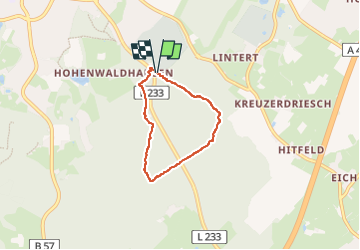

Longueur
4,1 km

Altitude max
299 m

Dénivelé positif
70 m
Km-Effort
5,1 km

Altitude min
248 m

Dénivelé négatif
74 m
Boucle
Oui
Date de création :
2024-10-12 12:54:56.766
Dernière modification :
2024-10-12 14:16:25.25
1h08
Difficulté : Facile

Application GPS de randonnée GRATUITE
 SityTrail
IGN / Instituts géographiques
SityTrail Plus
Le monde est à vous
À propos
Randonnée Marche de 4,1 km à découvrir à Rhénanie-du-Nord-Westphalie, Région urbaine d'Aix-la-Chapelle, Aix-la-Chapelle. Cette randonnée est proposée par Lychee.
Localisation
Pays :
Allemagne
Région :
Rhénanie-du-Nord-Westphalie
Département/Province :
Région urbaine d'Aix-la-Chapelle
Commune :
Aix-la-Chapelle
Localité :
Aachen-Mitte
Départ:(Dec)
Départ:(UTM)
296048 ; 5625385 (32U) N.
Commentaires