


VTT

Alain Gasnot
Utilisateur

Longueur
6,8 km

Altitude max
121 m

Dénivelé positif
57 m
Km-Effort
7,5 km

Altitude min
94 m

Dénivelé négatif
58 m
Boucle
Oui
Date de création :
2024-10-27 15:09:06.638
Dernière modification :
2024-10-27 16:29:32.586
1h19
Difficulté : Facile

Application GPS de randonnée GRATUITE
 SityTrail
IGN / Instituts géographiques
SityTrail Plus
Le monde est à vous
À propos
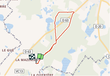
Randonnée V.T.T. de 6,8 km à découvrir à Centre-Val de Loire, Loir-et-Cher, Mur-de-Sologne. Cette randonnée est proposée par Alain Gasnot.
Localisation
Pays :
France
Région :
Centre-Val de Loire
Département/Province :
Loir-et-Cher
Commune :
Mur-de-Sologne
Localité :
Unknown
Départ:(Dec)
Départ:(UTM)
392378 ; 5248986 (31T) N.
Commentaires