


Rando VTT st_pons_50km_2025

mthomas30
Utilisateur
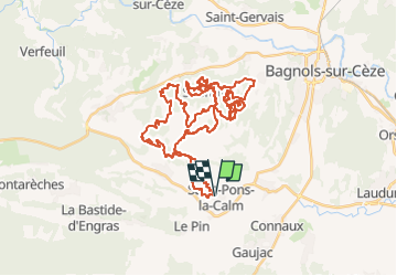

Longueur
50 km

Altitude max
290 m

Dénivelé positif
1173 m
Km-Effort
66 km

Altitude min
81 m

Dénivelé négatif
1173 m
Boucle
Oui
Date de création :
2025-01-15 07:44:01.434
Dernière modification :
2025-01-29 08:08:03.509
4h33
Difficulté : Très difficile

Application GPS de randonnée GRATUITE
 SityTrail
IGN / Instituts géographiques
SityTrail Plus
Le monde est à vous
À propos
Randonnée V.T.T. de 50 km à découvrir à Occitanie, Gard, Saint-Pons-la-Calm. Cette randonnée est proposée par mthomas30.
Localisation
Pays :
France
Région :
Occitanie
Département/Province :
Gard
Commune :
Saint-Pons-la-Calm
Localité :
Unknown
Départ:(Dec)
Départ:(UTM)
624440 ; 4884670 (31T) N.
Commentaires