![](/images/other/stat-length.png)
Libramont - 5.Promenade de la Briqueterie - LB008
La Grande Forêt de Saint-Hubert
Randonnées de la Grande Forêt de Saint-Hubert GUIDE+
![Longueur](/images/other/stat-length.png)
Longueur
6,8 km
![Altitude max](https://static1.geolcdn.com/siteimages/upload/files/1508320355ic_sort_altitude_max_24dp.png)
Altitude max
560 m
![Dénivelé positif](https://static1.geolcdn.com/siteimages/upload/files/1508320355ic_sort_den_pos_24dp.png)
Dénivelé positif
127 m
![Km-Effort](/images/other/stat-length.png)
Km-Effort
8,5 km
![Altitude min](https://static1.geolcdn.com/siteimages/upload/files/1508320355ic_sort_altitude_min_24dp.png)
Altitude min
501 m
![Dénivelé négatif](https://static1.geolcdn.com/siteimages/upload/files/1508320355ic_sort_den_neg_24dp.png)
Dénivelé négatif
126 m
![Boucle](https://static1.geolcdn.com/siteimages/upload/files/16400158638029165_repeat_loop_refresh_sync_direction_icon.png)
Boucle
Oui
![Balise](https://services.sitytrail.com/GeolivesWS/DownloadMedia.ashx?TrailID=436759&Media=balise.png)
Balise
Date de création :
2018-01-12 00:00:00.0
Dernière modification :
2020-12-02 12:56:53.886
![Marche](https://static1.geolcdn.com/sitytour/trail-icons/101.png)
2h01
Difficulté : Moyen
![Scannez ce code QR pour ouvrir la randonnée dans l'application SityTrail](https://capi.geolives.com/qq0zvz2zws4bq2lad0pu/sitytour/trails/436759/qr.png?size=200)
Application GPS de randonnée GRATUITE
À propos
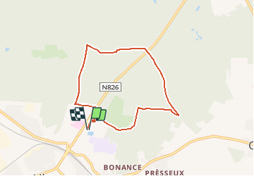
Randonnée Marche de 6,8 km à découvrir à Wallonie, Luxembourg, Libramont-Chevigny. Cette randonnée est proposée par La Grande Forêt de Saint-Hubert.
Description
Probablement la promenade forestière la plus accessible. Pas trop de montées et des chemins assez larges et faciles d’accès.
Localisation
Pays :
Belgique
Région :
Wallonie
Département/Province :
Luxembourg
Commune :
Libramont-Chevigny
Localité :
Libramont
Départ:(Dec)
Départ:(UTM)
671006 ; 5532947 (31U) N.
Commentaires
Randonnées à proximité
![Randonnée Marche Libramont-Chevigny - Marche ADEPS à Séviscourt. - Photo](https://media.geolcdn.com/t/375/260/ext.jpg?maxdim=2&url=https%3A%2F%2Fmedia.geolcdn.com%2Ff%2Fa1af7c4b-992e-4843-a6a5-dfa52ee754c1.jpg)
![Marche Marche](https://static1.geolcdn.com/sitytour/trail-icons/101.png)
Marche ADEPS à Séviscourt.
Marche
Facile
(1)
Libramont-Chevigny,
Wallonie,
Luxembourg,
Belgique
![](/images/other/stat-length.png)
10,3 km | 13,5 km-effort
2h 8min
![](https://static1.geolcdn.com/siteimages/upload/files/16400158638029165_repeat_loop_refresh_sync_direction_icon.png)
Oui
![Randonnée Marche Libramont-Chevigny - 5. Promenade non balisée au départ du village de Lamouline - Photo](https://media.geolcdn.com/t/375/260/ext.jpg?maxdim=2&url=https%3A%2F%2Fservices.sitytrail.com%2FGeolivesWS%2FDownloadMedia.ashx%3FTrailID%3D537894%26Media%3Dd4f09763-3f4e-4f58-b9ef-7a20178fcd7b.jpg)
![Marche Marche](https://static1.geolcdn.com/sitytour/trail-icons/101.png)
5. Promenade non balisée au départ du village de Lamouline
Marche
Facile
(2)
Libramont-Chevigny,
Wallonie,
Luxembourg,
Belgique
![](/images/other/stat-length.png)
5 km | 6,1 km-effort
1h 21min
![](https://static1.geolcdn.com/siteimages/upload/files/16400158638029165_repeat_loop_refresh_sync_direction_icon.png)
Oui
![Randonnée Marche Libramont-Chevigny - Libramont - 8. La promenade des Tchèts - LB011 - Photo](https://media.geolcdn.com/t/375/260/ext.jpg?maxdim=2&url=https%3A%2F%2Fservices.sitytrail.com%2FGeolivesWS%2FDownloadMedia.ashx%3FTrailID%3D442633%26Media%3D8ab8b917-8443-457f-8363-9f761d3ed013.JPG)
![Marche Marche](https://static1.geolcdn.com/sitytour/trail-icons/101.png)
Libramont - 8. La promenade des Tchèts - LB011 ...
Marche
Difficile
(2)
Libramont-Chevigny,
Wallonie,
Luxembourg,
Belgique
![](/images/other/stat-length.png)
10,6 km | 13,1 km-effort
3h 9min
![](https://static1.geolcdn.com/siteimages/upload/files/16400158638029165_repeat_loop_refresh_sync_direction_icon.png)
Oui
![Randonnée Marche Libramont-Chevigny - Libramont - 3.Voie Saint-Antoine - LB006 - Photo](https://media.geolcdn.com/t/375/260/ext.jpg?maxdim=2&url=https%3A%2F%2Fservices.sitytrail.com%2FGeolivesWS%2FDownloadMedia.ashx%3FTrailID%3D435461%26Media%3D9c2a9845-3837-4f3e-afd6-579a4ed1754d.JPG)
![Marche Marche](https://static1.geolcdn.com/sitytour/trail-icons/101.png)
Libramont - 3.Voie Saint-Antoine - LB006
Marche
Très difficile
(2)
Libramont-Chevigny,
Wallonie,
Luxembourg,
Belgique
![](/images/other/stat-length.png)
17,9 km | 22 km-effort
6h 21min
![](https://static1.geolcdn.com/siteimages/upload/files/16400158638029165_repeat_loop_refresh_sync_direction_icon.png)
Oui
![Randonnée Marche Libramont-Chevigny - marche ADEPS Libramont - Photo](https://media.geolcdn.com/t/375/260/ext.jpg?maxdim=2&url=https%3A%2F%2Fmedia.geolcdn.com%2Ff%2F335bd56e-e2bf-45e7-9e07-2e37ce966e5f.jpg)
![Marche Marche](https://static1.geolcdn.com/sitytour/trail-icons/101.png)
marche ADEPS Libramont
Marche
Moyen
(1)
Libramont-Chevigny,
Wallonie,
Luxembourg,
Belgique
![](/images/other/stat-length.png)
9,6 km | 12,2 km-effort
2h 8min
![](https://static1.geolcdn.com/siteimages/upload/files/16400158638029165_repeat_loop_refresh_sync_direction_icon.png)
Oui
![Randonnée Marche Libramont-Chevigny - Nuit du scoutisme - Libramont - Photo](https://media.geolcdn.com/t/375/260/ext.jpg?maxdim=2&url=https%3A%2F%2Fmedia.geolcdn.com%2Ff%2F1ae90a2d-2bc2-4abc-86f6-3db7cf44d5c2.jpg)
![Marche Marche](https://static1.geolcdn.com/sitytour/trail-icons/101.png)
Nuit du scoutisme - Libramont
Marche
Facile
(2)
Libramont-Chevigny,
Wallonie,
Luxembourg,
Belgique
![](/images/other/stat-length.png)
4,9 km | 5,8 km-effort
1h 18min
![](https://static1.geolcdn.com/siteimages/upload/files/16400158638029165_repeat_loop_refresh_sync_direction_icon.png)
Oui
![Randonnée Marche Libramont-Chevigny - Promenade pédagogique celtique - Photo](https://media.geolcdn.com/t/375/260/ext.jpg?maxdim=2&url=https%3A%2F%2Fservices.sitytrail.com%2FGeolivesWS%2FDownloadMedia.ashx%3FTrailID%3D767953%26Media%3Da77e25ec-09c3-43b4-9a1e-08e7083c9c0f.jpg)
![Marche Marche](https://static1.geolcdn.com/sitytour/trail-icons/101.png)
Promenade pédagogique celtique
Marche
Facile
(3)
Libramont-Chevigny,
Wallonie,
Luxembourg,
Belgique
![](/images/other/stat-length.png)
3 km | 3,7 km-effort
49min
![](https://static1.geolcdn.com/siteimages/upload/files/16400158638029165_repeat_loop_refresh_sync_direction_icon.png)
Oui
![Randonnée Marche Libramont-Chevigny - Libramont - marche des flocons 10 km - Photo](https://media.geolcdn.com/t/375/260/ext.jpg?maxdim=2&url=https%3A%2F%2Fservices.sitytrail.com%2FGeolivesWS%2FDownloadMedia.ashx%3FTrailID%3D684571%26Media%3Dfix__20170115102402.jpg)
![Marche Marche](https://static1.geolcdn.com/sitytour/trail-icons/101.png)
Libramont - marche des flocons 10 km
Marche
Facile
(1)
Libramont-Chevigny,
Wallonie,
Luxembourg,
Belgique
![](/images/other/stat-length.png)
10,2 km | 13 km-effort
2h 6min
![](https://static1.geolcdn.com/siteimages/upload/files/16400158638029165_repeat_loop_refresh_sync_direction_icon.png)
Oui
![Randonnée Marche Libramont-Chevigny - Bonance - Photo](https://media.geolcdn.com/t/375/260/ext.jpg?maxdim=2&url=https%3A%2F%2Fservices.sitytrail.com%2FGeolivesWS%2FDownloadMedia.ashx%3FTrailID%3D156107%26Media%3D20120930171822.jpeg)
![Marche Marche](https://static1.geolcdn.com/sitytour/trail-icons/101.png)
Bonance
Marche
Facile
(1)
Libramont-Chevigny,
Wallonie,
Luxembourg,
Belgique
![](/images/other/stat-length.png)
9,4 km | 11,7 km-effort
2h 28min
![](https://static1.geolcdn.com/siteimages/upload/files/16400158638029165_repeat_loop_refresh_sync_direction_icon.png)
Oui
Belle promenade. Dommage que le Chemin est truffé de trace laissant la place a la boue, de la gadoue même a certains endroits. Très bien balisé. A faire avec de bonnes chaussures de marche.
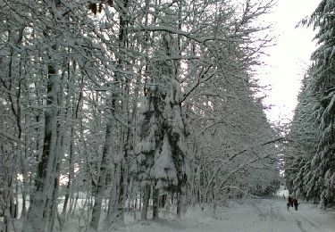
top sous la neige
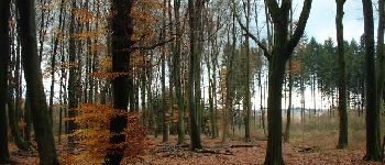
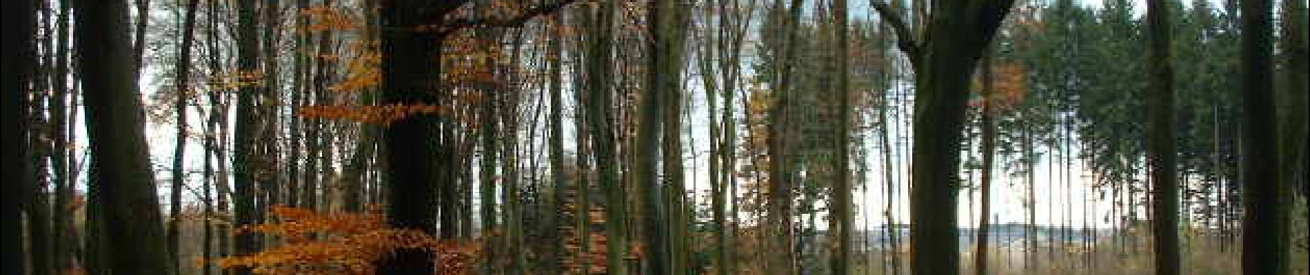
Très jolie balade, en particulier en automne où le couleurs de la forêt sont splendides