


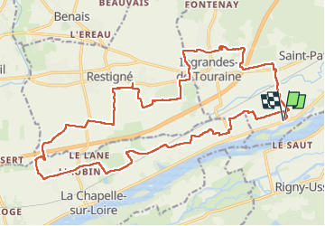
Saint-Patrice Port-Charbonnier - via PRs et GRP - 24.7km 155m 5h15 (1h) - 2025 03 05

Orcal37
Utilisateur GUIDE

Longueur
25 km

Altitude max
108 m

Dénivelé positif
157 m
Km-Effort
27 km

Altitude min
28 m

Dénivelé négatif
157 m
Boucle
Oui
Date de création :
2025-03-05 09:40:45.39
Dernière modification :
2025-03-08 12:53:41.794
5h15
Difficulté : Facile

Application GPS de randonnée GRATUITE
 SityTrail
IGN / Instituts géographiques
SityTrail Plus
Le monde est à vous
À propos
Randonnée Marche de 25 km à découvrir à Centre-Val de Loire, Indre-et-Loire, Coteaux-sur-Loire. Cette randonnée est proposée par Orcal37.
Description
Saint-Patrice Port-Charbonnier - via PRs et GRP - Communes de Ingrandes-de-Touraine Restigné la Chapelle-sur-Loire - 24.7km 155m 5h15 (1h) - 2025 03 05
Photos
 - 2025 03 05 - Photo 1")
 - 2025 03 05 - Photo 2")
 - 2025 03 05 - Photo 3")
 - 2025 03 05 - Photo 4")
 - 2025 03 05 - Photo 5")
 - 2025 03 05 - Photo 6")
 - 2025 03 05 - Photo 7")
 - 2025 03 05 - Photo 8")
 - 2025 03 05 - Photo 9")
 - 2025 03 05 - Photo 10")
Localisation
Pays :
France
Région :
Centre-Val de Loire
Département/Province :
Indre-et-Loire
Commune :
Coteaux-sur-Loire
Localité :
Saint-Patrice
Départ:(Dec)
Départ:(UTM)
295408 ; 5238672 (31T) N.
Commentaires