


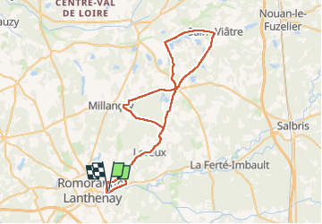
romo loreux marcilly st vitre rte étangs millancay loreux romo

mimilolo
Utilisateur

Longueur
60 km

Altitude max
132 m

Dénivelé positif
432 m
Km-Effort
66 km

Altitude min
90 m

Dénivelé négatif
432 m
Boucle
Oui
Date de création :
2025-04-28 12:20:26.421
Dernière modification :
2025-04-28 21:18:11.939
2h30
Difficulté : Très facile

Application GPS de randonnée GRATUITE
 SityTrail
IGN / Instituts géographiques
SityTrail Plus
Le monde est à vous
À propos
Randonnée Vélo de route de 60 km à découvrir à Centre-Val de Loire, Loir-et-Cher, Romorantin-Lanthenay. Cette randonnée est proposée par mimilolo.
Localisation
Pays :
France
Région :
Centre-Val de Loire
Département/Province :
Loir-et-Cher
Commune :
Romorantin-Lanthenay
Localité :
Unknown
Départ:(Dec)
Départ:(UTM)
407023 ; 5245707 (31T) N.
Commentaires