


Athée-sur-Cher - Chandon - Tour du Brandon - 21.2km 160m 4h40 (50mn) - 2025 05 10

Orcal37
Utilisateur GUIDE
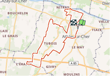

Longueur
21 km

Altitude max
106 m

Dénivelé positif
160 m
Km-Effort
23 km

Altitude min
51 m

Dénivelé négatif
159 m
Boucle
Oui
Date de création :
2025-05-10 08:46:51.487
Dernière modification :
2025-05-11 12:49:54.185
4h40
Difficulté : Facile

Application GPS de randonnée GRATUITE
 SityTrail
IGN / Instituts géographiques
SityTrail Plus
Le monde est à vous
À propos
Randonnée Marche de 21 km à découvrir à Centre-Val de Loire, Indre-et-Loire, Athée-sur-Cher. Cette randonnée est proposée par Orcal37.
Description
Athée-sur-Cher - Chandon - Tour du Brandon - variante du PR nommé De la Tour au Château (16km) qui ne passe pas par Chandon - 21.2km 160m 4h40 (50mn) - 2025 05 10
Photos
 - 2025 05 10 - Photo 1")
 - 2025 05 10 - Photo 2")
 - 2025 05 10 - Photo 3")
 - 2025 05 10 - Photo 4")
 - 2025 05 10 - Photo 5")
 - 2025 05 10 - Photo 6")
 - 2025 05 10 - Photo 7")
 - 2025 05 10 - Photo 8")
 - 2025 05 10 - Photo 9")
 - 2025 05 10 - Photo 10")
 - 2025 05 10 - Photo 11")
 - 2025 05 10 - Photo 12")
Localisation
Pays :
France
Région :
Centre-Val de Loire
Département/Province :
Indre-et-Loire
Commune :
Athée-sur-Cher
Localité :
Unknown
Départ:(Dec)
Départ:(UTM)
342699 ; 5243534 (31T) N.
Commentaires