![](/images/other/stat-length.png)
![Randonnée Marche Chiny - Le long de la semois et sur les crêtes de Chiny - Photo](https://media.geolcdn.com/t/1900/400/ext.pjpeg?maxdim=2&url=https%3A%2F%2Fservices.sitytrail.com%2FGeolivesWS%2FDownloadMedia.ashx%3FTrailID%3D453275%26Media%3D20150802184840.jpg)
Le long de la semois et sur les crêtes de Chiny
antoinebaetsle
Utilisateur
![Longueur](/images/other/stat-length.png)
Longueur
6,7 km
![Altitude max](https://static1.geolcdn.com/siteimages/upload/files/1508320355ic_sort_altitude_max_24dp.png)
Altitude max
378 m
![Dénivelé positif](https://static1.geolcdn.com/siteimages/upload/files/1508320355ic_sort_den_pos_24dp.png)
Dénivelé positif
118 m
![Km-Effort](/images/other/stat-length.png)
Km-Effort
8,3 km
![Altitude min](https://static1.geolcdn.com/siteimages/upload/files/1508320355ic_sort_altitude_min_24dp.png)
Altitude min
307 m
![Dénivelé négatif](https://static1.geolcdn.com/siteimages/upload/files/1508320355ic_sort_den_neg_24dp.png)
Dénivelé négatif
118 m
![Boucle](https://static1.geolcdn.com/siteimages/upload/files/16400158638029165_repeat_loop_refresh_sync_direction_icon.png)
Boucle
Oui
Date de création :
2015-08-03 00:00:00.0
Dernière modification :
2015-08-03 00:00:00.0
![Marche](https://static1.geolcdn.com/sitytour/trail-icons/101.png)
1h53
Difficulté : Très facile
![Scannez ce code QR pour ouvrir la randonnée dans l'application SityTrail](https://capi.geolives.com/qq0zvz2zws4bq2lad0pu/sitytour/trails/453275/qr.png?size=200)
Application GPS de randonnée GRATUITE
À propos
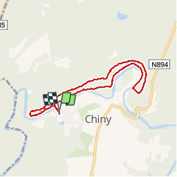
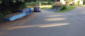
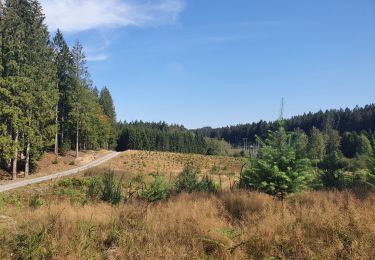
Randonnée Marche de 6,7 km à découvrir à Wallonie, Luxembourg, Chiny. Cette randonnée est proposée par antoinebaetsle.
Description
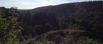
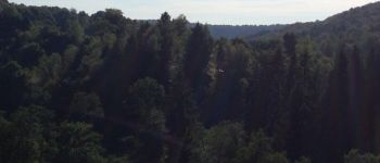
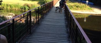
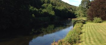
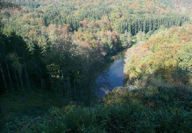
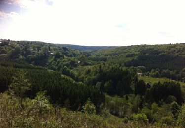
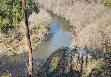
Petite balade le long de la Semois sur de beaux chemin sinueux. Après être monté sur la crête, profitez d'un magnifique panorama sur la vallée de la Semois.
Points d'intérêt
Localisation
Pays :
Belgique
Région :
Wallonie
Département/Province :
Luxembourg
Commune :
Chiny
Localité :
Chiny
Départ:(Dec)
Départ:(UTM)
667858 ; 5512260 (31U) N.
Commentaires
Randonnées à proximité
![Randonnée Marche Florenville - RB-Lu-14_Lacuisine - Photo](https://media.geolcdn.com/t/375/260/ext.jpg?maxdim=2&url=https%3A%2F%2Fservices.sitytrail.com%2FGeolivesWS%2FDownloadMedia.ashx%3FTrailID%3D179620%26Media%3D4ddebe42-f4ef-4430-a594-18137c26d0fd.jpg)
![Marche Marche](https://static1.geolcdn.com/sitytour/trail-icons/101.png)
RB-Lu-14_Lacuisine
Marche
Moyen
(3)
Florenville,
Wallonie,
Luxembourg,
Belgique
![](/images/other/stat-length.png)
24 km | 31 km-effort
6h 8min
![](https://static1.geolcdn.com/siteimages/upload/files/16400158638029165_repeat_loop_refresh_sync_direction_icon.png)
Oui
![Randonnée Marche Florenville - rando les epioux 15/09/2020 - Photo](https://media.geolcdn.com/t/375/260/ext.jpg?maxdim=2&url=https%3A%2F%2Fmedia.geolcdn.com%2Ff%2Ff418135f-9d94-414f-b063-7d7f558c9ced.jpg)
![Marche Marche](https://static1.geolcdn.com/sitytour/trail-icons/101.png)
rando les epioux 15/09/2020
Marche
Très facile
(1)
Florenville,
Wallonie,
Luxembourg,
Belgique
![](/images/other/stat-length.png)
18,1 km | 23 km-effort
4h 7min
![](https://static1.geolcdn.com/siteimages/upload/files/16400158638029165_repeat_loop_refresh_sync_direction_icon.png)
Oui
![Randonnée Marche Chiny - Semois, rochers et étangs - Photo](https://media.geolcdn.com/t/375/260/ext.jpg?maxdim=2&url=https%3A%2F%2Fmedia.geolcdn.com%2Ff%2Faad7bb70-f961-4423-a769-93d92e58c39f.jpg)
![Marche Marche](https://static1.geolcdn.com/sitytour/trail-icons/101.png)
Semois, rochers et étangs
Marche
Difficile
(2)
Chiny,
Wallonie,
Luxembourg,
Belgique
![](/images/other/stat-length.png)
14,8 km | 19,4 km-effort
2h 41min
![](https://static1.geolcdn.com/siteimages/upload/files/16400158638029165_repeat_loop_refresh_sync_direction_icon.png)
Oui
![Randonnée Marche Chiny - Autour de la forêt de Chiny - Photo](https://media.geolcdn.com/t/375/260/ext.jpg?maxdim=2&url=https%3A%2F%2Fservices.sitytrail.com%2FGeolivesWS%2FDownloadMedia.ashx%3FTrailID%3D422130%26Media%3Dfix__20150517155004.jpg)
![Marche Marche](https://static1.geolcdn.com/sitytour/trail-icons/101.png)
Autour de la forêt de Chiny
Marche
Facile
(1)
Chiny,
Wallonie,
Luxembourg,
Belgique
![](/images/other/stat-length.png)
12 km | 15,3 km-effort
2h 37min
![](https://static1.geolcdn.com/siteimages/upload/files/16400158638029165_repeat_loop_refresh_sync_direction_icon.png)
Oui
![Randonnée Marche Chiny - wandeling chiny - Photo](https://media.geolcdn.com/t/375/260/ext.jpg?maxdim=2&url=https%3A%2F%2Fservices.sitytrail.com%2FGeolivesWS%2FDownloadMedia.ashx%3FTrailID%3D130577%26Media%3D20120527164214.jpg)
![Marche Marche](https://static1.geolcdn.com/sitytour/trail-icons/101.png)
wandeling chiny
Marche
Très facile
(2)
Chiny,
Wallonie,
Luxembourg,
Belgique
![](/images/other/stat-length.png)
7,4 km | 9,5 km-effort
1h 41min
![](https://static1.geolcdn.com/siteimages/upload/files/16400158638029165_repeat_loop_refresh_sync_direction_icon.png)
Oui
![Randonnée Marche Chiny - RF-Lu-13 - Entre Semois et Vierre : Chiny - Photo](https://media.geolcdn.com/t/375/260/ext.jpg?maxdim=2&url=https%3A%2F%2Fstatic1.geolcdn.com%2Fsiteimages%2Fupload%2Ffiles%2F1553511878bg_sport_marche.png)
![Marche Marche](https://static1.geolcdn.com/sitytour/trail-icons/101.png)
RF-Lu-13 - Entre Semois et Vierre : Chiny
Marche
Très facile
(2)
Chiny,
Wallonie,
Luxembourg,
Belgique
![](/images/other/stat-length.png)
10,9 km | 14,1 km-effort
3h 4min
![](https://static1.geolcdn.com/siteimages/upload/files/16400158638029165_repeat_loop_refresh_sync_direction_icon.png)
Oui
![Randonnée Marche Florenville - marche ADEPS à Chassepierre. - Photo](https://media.geolcdn.com/t/375/260/ext.jpg?maxdim=2&url=https%3A%2F%2Fmedia.geolcdn.com%2Ff%2Fc3422bd1-8f1e-4c26-a509-39433ec6f633.jpg)
![Marche Marche](https://static1.geolcdn.com/sitytour/trail-icons/101.png)
marche ADEPS à Chassepierre.
Marche
Moyen
(1)
Florenville,
Wallonie,
Luxembourg,
Belgique
![](/images/other/stat-length.png)
11,4 km | 14,3 km-effort
2h 49min
![](https://static1.geolcdn.com/siteimages/upload/files/16400158638029165_repeat_loop_refresh_sync_direction_icon.png)
Oui
![Randonnée Marche Florenville - Marche ADEPS Chassepierre - Photo](https://media.geolcdn.com/t/375/260/ext.jpg?maxdim=2&url=https%3A%2F%2Fmedia.geolcdn.com%2Ff%2Fa02e2830-f1b1-4b5d-b569-0006471ce904.jpg)
![Marche Marche](https://static1.geolcdn.com/sitytour/trail-icons/101.png)
Marche ADEPS Chassepierre
Marche
Difficile
Florenville,
Wallonie,
Luxembourg,
Belgique
![](/images/other/stat-length.png)
13,1 km | 16,3 km-effort
3h 2min
![](https://static1.geolcdn.com/siteimages/upload/files/16400158638029165_repeat_loop_refresh_sync_direction_icon.png)
Oui
![Randonnée A pied Chiny - 36. Le Charmois - Photo](https://media.geolcdn.com/t/375/260/ext.jpg?maxdim=2&url=https%3A%2F%2Fmedia.geolcdn.com%2Ff%2Fe5ff35e5-2a23-4c0e-9e14-1099896dc85e.jpeg)
![A pied A pied](https://static1.geolcdn.com/sitytour/trail-icons/100.png)
36. Le Charmois
A pied
Facile
Chiny,
Wallonie,
Luxembourg,
Belgique
![](/images/other/stat-length.png)
13,7 km | 16,3 km-effort
3h 42min
![](https://static1.geolcdn.com/siteimages/upload/files/16400158638029165_repeat_loop_refresh_sync_direction_icon.png)
Oui