Randonnée Marche S-chanf - YHH095 Schruns à Tirano (5e jour) - Photo

YHH095 Schruns à Tirano (5e jour)

 yveshumbert
yveshumbert

Utilisateur

© OpenStreetMap contributors
Longueur
Longueur
19,8 km
Altitude max
Altitude max
1807 m
Dénivelé positif
Dénivelé positif
365 m
Km-Effort
Km-Effort  
24 km
Altitude min
Altitude min
1663 m
Dénivelé négatif
Dénivelé négatif
228 m
Boucle
Boucle
Non
Date de création :
2015-09-03 00:00:00.0
Dernière modification :
2015-09-03 00:00:00.0

(0 Avis)

Marche
Marche
5h22
Difficulté : Très difficile

Scannez ce code QR pour ouvrir la randonnée dans l'application SityTrail

Application GPS de randonnée GRATUITE

Logo SityTrail SityTrail

IGN / Instituts géographiques

Télécharger SityTrail sur l'App Store Télécharger SityTrail sur Google Play

Logo SityTrail SityTrail World

Le monde est à vous

Télécharger SityTrail sur l'App Store Télécharger SityTrail sur Google Play Télécharger SityTrail sur Huawei AppGallery

À propos

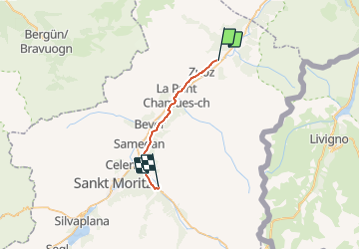
Randonnée Marche de 19,8 km à découvrir à Grisons, Maloja, S-chanf. Cette randonnée est proposée par yveshumbert.

Description

Randonnée de 8 jours au départ de Schruns (Autriche) et arrivée à Tirano (Italie). Etape # 5 S-Champf à Pontresina.
Une étape avec peu de dénivelé, mais longue.
L itinéraire traverse les villages de Zuoz, Madulain, La Punt Chamue, Champesh.
On passe aussi a proximité de Bevers, Samedan.
Dans pratiquement tous ces villages, il y a la possibilité de se restaurer et de prendre un train ou un bus pour pontresina.
A Pontresina il y a un bon choix d' hôtels pour dormir et se restaurer.

Profil altimétrique

Points d'intérêt

Point d'intérêt La Punt Chamues-ch - Champesch - Photo
yveshumbert
LA PUNT CHAMUES-CH 
Point d'intérêt Samedan - Samedan - Photo
yveshumbert
SAMEDAN 
Point d'intérêt Pontresina - Punt Muragl - Photo
yveshumbert
PONTRESINA 
Point d'intérêt Pontresina - Pontresina - Photo
yveshumbert
PONTRESINA 
Point d'intérêt S-chanf - S-champf - Photo
yveshumbert
S-CHANF 
Point d'intérêt Zuoz - Zuoz - Photo
yveshumbert
ZUOZ 
Point d'intérêt Madulain - Madulain - Photo
yveshumbert
MADULAIN 
Point d'intérêt La Punt Chamues-ch - Chamues-ch - Photo
yveshumbert
LA PUNT CHAMUES-CH 

Localisation

Pays :
Suisse
Région :
Grisons
Département/Province :
Maloja
Commune :
S-chanf
Localité :
Unknown
Départ:(Dec)
Départ:(UTM)
575272 ; 5162465 (32T) N.

Randonnées à proximité

Randonnée Marche Zuoz - mtb03 - Photo
Marche
GUIDE+

Marche

Très facile
Zuoz, Grisons, Maloja, Suisse
37 km | 49 km-effort
Inconnu
Oui
Randonnée V.T.T. S-chanf - Bike6Bike32858 - Photo
V.T.T.
GUIDE+

V.T.T.

Très facile
S-chanf, Grisons, Maloja, Suisse
48 km | 63 km-effort
Inconnu
Non
Randonnée Autre activité S-chanf - Val Trupchun - Photo
Autre activité
steger12

Autre activité

Très facile
S-chanf, Grisons, Maloja, Suisse
7 km | 12,3 km-effort
Inconnu
Non
Randonnée Autre activité S-chanf - Val Trupchun - Photo
Autre activité
bffcuc

Autre activité

Très facile
S-chanf, Grisons, Maloja, Suisse
13,7 km | 20 km-effort
3h 34min
Oui
Randonnée V.T.T. S-chanf - WallisBike 18 S-chanf - Livigno - Photo
V.T.T.
ovronne

V.T.T.

Très facile
S-chanf, Grisons, Maloja, Suisse
23 km | 39 km-effort
2h 59min
Non
Randonnée Autre activité Zuoz - Zuoz-Bergün - Photo
Autre activité
hallauer

Autre activité

Très facile
Zuoz, Grisons, Maloja, Suisse
14,8 km | 31 km-effort
Inconnu
Non


Fermer
Mes abonnements