Randonnée V.T.T. Aix-la-Chapelle - 20151010 Aachen Montjoie - Photo

Plus vî, plus sot

© OpenStreetMap contributors
Longueur
Longueur
54 km
Altitude max
Altitude max
584 m
Dénivelé positif
Dénivelé positif
990 m
Km-Effort
Km-Effort  
66 km
Altitude min
Altitude min
197 m
Dénivelé négatif
Dénivelé négatif
770 m
Boucle
Boucle
Non
Date de création :
2015-10-12 00:00:00.0
Dernière modification :
2015-10-12 00:00:00.0

(0 Avis)

V.T.T.
V.T.T.
4h20
Difficulté : Moyen

Scannez ce code QR pour ouvrir la randonnée dans l'application SityTrail

Application GPS de randonnée GRATUITE

Logo SityTrail SityTrail

IGN / Instituts géographiques

Télécharger SityTrail sur l'App Store Télécharger SityTrail sur Google Play

Logo SityTrail SityTrail World

Le monde est à vous

Télécharger SityTrail sur l'App Store Télécharger SityTrail sur Google Play Télécharger SityTrail sur Huawei AppGallery

À propos

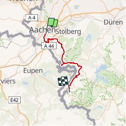
Randonnée V.T.T. de 54 km à découvrir à Rhénanie-du-Nord-Westphalie, Région urbaine d'Aix-la-Chapelle, Aix-la-Chapelle. Cette randonnée est proposée par Yeyette VTT team.

Description

Super parcours de vrai VTT. Quelques racines n'ont pas plus à tout le monde...

Profil altimétrique

Photos

Points d'intérêt

Point d'intérêt Montjoie - Monschau - Photo
NanardPet
MONTJOIE 

Localisation

Pays :
Allemagne
Région :
Rhénanie-du-Nord-Westphalie
Département/Province :
Région urbaine d'Aix-la-Chapelle
Commune :
Aix-la-Chapelle
Localité :
Aachen-Mitte
Départ:(Dec)
Départ:(UTM)
295913 ; 5627089 (32U) N.

Randonnées à proximité

Randonnée Marche Raeren - Aix-la-Chapelle_392 - Photo
Marche
GUIDE
mumu.larandonneuse

Marche

Moyen
(1)
Raeren, Wallonie, Liège, Belgique
13,2 km | 17,3 km-effort
3h 55min
Oui
Randonnée Marche Aix-la-Chapelle - Aix-la-Chapelle  - Photo
Marche
GUIDE
mumu.larandonneuse

Marche

Facile
(1)
Aix-la-Chapelle, Rhénanie-du-Nord-Westphalie, Région urbaine d'Aix-la-Chapelle, Allemagne
11,4 km | 15,4 km-effort
3h 30min
Oui
Randonnée Marche Aix-la-Chapelle - Aix-la-Chapelle  - Photo
Marche
GUIDE
mumu.larandonneuse

Marche

Facile
(1)
Aix-la-Chapelle, Rhénanie-du-Nord-Westphalie, Région urbaine d'Aix-la-Chapelle, Allemagne
11,1 km | 13,4 km-effort
3h 2min
Oui
Randonnée Marche Aix-la-Chapelle - Aix-la-Chapelle (Rando & marché de Noël 🎅🎄) - Photo
Marche
GUIDE
mumu.larandonneuse

Marche

Facile
(1)
Aix-la-Chapelle, Rhénanie-du-Nord-Westphalie, Région urbaine d'Aix-la-Chapelle, Allemagne
10,7 km | 13,2 km-effort
3h 0min
Oui
Randonnée A pied Aix-la-Chapelle - Rundweg um Eilendorf - Photo
A pied
PRO

A pied

Facile
Aix-la-Chapelle, Rhénanie-du-Nord-Westphalie, Région urbaine d'Aix-la-Chapelle, Allemagne
12,6 km | 14,4 km-effort
3h 16min
Oui
Randonnée A pied Aix-la-Chapelle - Forsthausrundweg - Photo
A pied
PRO

A pied

Facile
Aix-la-Chapelle, Rhénanie-du-Nord-Westphalie, Région urbaine d'Aix-la-Chapelle, Allemagne
5,2 km | 5,8 km-effort
1h 19min
Oui
Randonnée A pied Aix-la-Chapelle - GrenzRouten: Verbindungsweg Aachen Hbf - Köpfchen - Photo
A pied
PRO

A pied

Facile
Aix-la-Chapelle, Rhénanie-du-Nord-Westphalie, Région urbaine d'Aix-la-Chapelle, Allemagne
4,1 km | 5 km-effort
1h 8min
Non
Randonnée A pied Aix-la-Chapelle - GrenzRouten: Verbindungsweg Aachen Hbf - Entenpfuhl - Photo
A pied
PRO

A pied

Facile
Aix-la-Chapelle, Rhénanie-du-Nord-Westphalie, Région urbaine d'Aix-la-Chapelle, Allemagne
5,1 km | 6,7 km-effort
1h 31min
Non
Randonnée A pied Aix-la-Chapelle - GrenzRouten: Verbindungsweg Aachen Hbf - Kornelimünster (
A pied
PRO

A pied

Facile
Aix-la-Chapelle, Rhénanie-du-Nord-Westphalie, Région urbaine d'Aix-la-Chapelle, Allemagne
6,5 km | 7,7 km-effort
1h 45min
Non


Fermer
Mes abonnements