Randonnée Marche Saint-Hilaire-de-Villefranche - Boucle de la Frédière par Fenioux - Photo
 tupeutla
tupeutla

Utilisateur

© OpenStreetMap contributors
Longueur
Longueur
12,5 km
Altitude max
Altitude max
99 m
Dénivelé positif
Dénivelé positif
219 m
Km-Effort
Km-Effort  
15,5 km
Altitude min
Altitude min
18 m
Dénivelé négatif
Dénivelé négatif
223 m
Boucle
Boucle
Oui
Date de création :
2015-11-04 00:00:00.0
Dernière modification :
2015-11-04 00:00:00.0

(0 Avis)

Marche
Marche
3h20
Difficulté : Moyen

Scannez ce code QR pour ouvrir la randonnée dans l'application SityTrail

Application GPS de randonnée GRATUITE

Logo SityTrail SityTrail

IGN / Instituts géographiques

Télécharger SityTrail sur l'App Store Télécharger SityTrail sur Google Play

Logo SityTrail SityTrail World

Le monde est à vous

Télécharger SityTrail sur l'App Store Télécharger SityTrail sur Google Play Télécharger SityTrail sur Huawei AppGallery

À propos

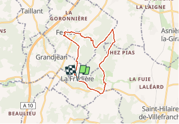
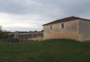
Randonnée Marche de 12,5 km à découvrir à Nouvelle-Aquitaine, Charente-Maritime, Saint-Hilaire-de-Villefranche. Cette randonnée est proposée par tupeutla.

Description

Une jolie balade entre bois et vignes avec quelques passages difficiles par temps pluvieux.
Elle emprunte le chemin de St Jacques entre Fenioux et la Frédière.

Profil altimétrique

Points d'intérêt

Point d'intérêt Grandjean - L'arbre mort - Photo
tupeutla
GRANDJEAN 
Point d'intérêt Saint-Hilaire-de-Villefranche - Eglise et cimetière du XII éme - Photo
tupeutla
SAINT-HILAIRE-DE-VILLEFRANCHE 
Point d'intérêt Saint-Hilaire-de-Villefranche - point de vue - Photo
tupeutla
SAINT-HILAIRE-DE-VILLEFRANCHE 
Point d'intérêt Saint-Hilaire-de-Villefranche - la Chrétignière - Photo
tupeutla
SAINT-HILAIRE-DE-VILLEFRANCHE 
Point d'intérêt Fenioux - photo ! - Photo
tupeutla
FENIOUX 
Point d'intérêt Fenioux - Fenioux - Photo
tupeutla
FENIOUX 
Point d'intérêt Fenioux - lanterne des Morts - Photo
tupeutla
Point d'intérêt Fenioux - ancien moulin à eau - Photo
tupeutla

Localisation

Pays :
France
Région :
Nouvelle-Aquitaine
Département/Province :
Charente-Maritime
Commune :
Saint-Hilaire-de-Villefranche
Localité :
Unknown
Départ:(Dec)
Départ:(UTM)
687228 ; 5081965 (30T) N.

Randonnées à proximité

Randonnée Vélo électrique Taillebourg - Taillebourg -Rochefort 13/09/22 - Photo
Vélo électrique
zoe.vienne

Vélo électrique

Moyen
Taillebourg, Nouvelle-Aquitaine, Charente-Maritime, France
56 km | 61 km-effort
4h 18min
Non
Randonnée Marche Fenioux - fenioux - Photo
Marche
niniroro51

Marche

Très facile
Fenioux, Nouvelle-Aquitaine, Charente-Maritime, France
6 km | 6,9 km-effort
2h 45min
Oui
Randonnée Marche Le Douhet - Le Douhet - Photo
Marche
mclafarie

Marche

Le Douhet, Nouvelle-Aquitaine, Charente-Maritime, France
4,5 km | 5,2 km-effort
1h 23min
Oui
Randonnée Marche Saint-Hilaire-de-Villefranche - St hilaire de villefranche - Photo
Marche
penaud

Marche

Moyen
Saint-Hilaire-de-Villefranche, Nouvelle-Aquitaine, Charente-Maritime, France
9,9 km | 11,6 km-effort
5h 9min
Oui
Randonnée Marche Taillebourg - Brizanbourg - Photo
Marche
mimosa55

Marche

Très facile
Taillebourg, Nouvelle-Aquitaine, Charente-Maritime, France
10,2 km | 11,6 km-effort
2h 33min
Non
Randonnée Marche Grandjean - grandjean gare - Photo
Marche
jcjacquiot

Marche

Facile
Grandjean, Nouvelle-Aquitaine, Charente-Maritime, France
5 km | 5,8 km-effort
1h 48min
Oui
Randonnée Marche Saint-Hilaire-de-Villefranche - A V F La Fredierev Chez Bouinaud - Photo
Marche
chesnel

Marche

Très facile
Saint-Hilaire-de-Villefranche, Nouvelle-Aquitaine, Charente-Maritime, France
6,8 km | 8,3 km-effort
1h 22min
Oui
Randonnée Marche Saint-Hilaire-de-Villefranche - comp 22 étape 2  - Photo
Marche
gwenola63

Marche

Très difficile
Saint-Hilaire-de-Villefranche, Nouvelle-Aquitaine, Charente-Maritime, France
19,9 km | 0 m-effort
8h 16min
Non
Randonnée Marche Saint-Hilaire-de-Villefranche - La Frediere - Photo
Marche
mclafarie

Marche

Très facile
Saint-Hilaire-de-Villefranche, Nouvelle-Aquitaine, Charente-Maritime, France
5,5 km | 6,9 km-effort
1h 31min
Oui


Fermer
Mes abonnements