Randonnée Marche Saint-Dionisy - oppidum de Nages - Photo
 kephas
kephas

Utilisateur

© OpenStreetMap contributors
Longueur
Longueur
6,8 km
Altitude max
Altitude max
178 m
Dénivelé positif
Dénivelé positif
185 m
Km-Effort
Km-Effort  
9,3 km
Altitude min
Altitude min
93 m
Dénivelé négatif
Dénivelé négatif
189 m
Boucle
Boucle
Oui
Date de création :
2015-12-04 00:00:00.0
Dernière modification :
2015-12-04 00:00:00.0

(0 Avis)

Marche
Marche
2h56
Difficulté : Très facile

Scannez ce code QR pour ouvrir la randonnée dans l'application SityTrail

Application GPS de randonnée GRATUITE

Logo SityTrail SityTrail

IGN / Instituts géographiques

Télécharger SityTrail sur l'App Store Télécharger SityTrail sur Google Play

Logo SityTrail SityTrail World

Le monde est à vous

Télécharger SityTrail sur l'App Store Télécharger SityTrail sur Google Play Télécharger SityTrail sur Huawei AppGallery

À propos

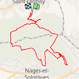
Randonnée Marche de 6,8 km à découvrir à Occitanie, Gard, Saint-Dionisy. Cette randonnée est proposée par kephas.

Description

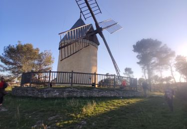
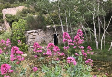
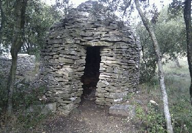
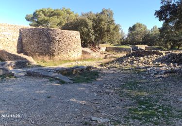
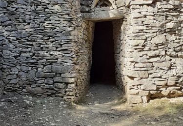
Joli circuit dans la fatigue avec de beaux points de vue et joli constructions de pierres sèches disséminées sur le parcours.

Profil altimétrique

Photos

Localisation

Pays :
France
Région :
Occitanie
Département/Province :
Gard
Commune :
Saint-Dionisy
Localité :
Unknown
Départ:(Dec)
Départ:(UTM)
598859 ; 4850678 (31T) N.

Randonnées à proximité

Randonnée Marche Saint-Côme-et-Maruéjols - Saint Côme et Maruéjols - Photo
Marche
poisson1103

Marche

Très facile
(1)
Saint-Côme-et-Maruéjols, Occitanie, Gard, France
13,8 km | 17,2 km-effort
5h 30min
Oui
Randonnée Marche Langlade - Langlade - Voie-verte Fontaine - Photo
Marche
rando30129

Marche

Moyen
(1)
Langlade, Occitanie, Gard, France
7,8 km | 9,1 km-effort
2h 4min
Oui
Randonnée Marche Caveirac - chemin des capitelles St Roch  - Photo
Marche
kephas

Marche

Très facile
(1)
Caveirac, Occitanie, Gard, France
8,8 km | 10,7 km-effort
5h 20min
Oui
Randonnée V.T.T. Calvisson - Espace VTT-FFC Pays de Sommières n°7 - Les Châteaux du Sommiérois - Photo
V.T.T.
tracegps

V.T.T.

Difficile
(1)
Calvisson, Occitanie, Gard, France
42 km | 50 km-effort
3h 30min
Oui
Randonnée Marche Saint-Dionisy - Opidum de Nages - Photo
Marche
CAMBON

Marche

Facile
(2)
Saint-Dionisy, Occitanie, Gard, France
6,8 km | 9,4 km-effort
2h 0min
Oui
Randonnée Marche Langlade - NAGES ET SOLORGUES - LA GRAND COMBE - 16.5Km - 04h30 - Dénivelé 340 m - Photo
Marche
dansmabulle

Marche

Moyen
(1)
Langlade, Occitanie, Gard, France
16,7 km | 22 km-effort
4h 34min
Oui
Randonnée Marche Nages-et-Solorgues - nages-langlades - Photo
Marche
v.rabot

Marche

Moyen
Nages-et-Solorgues, Occitanie, Gard, France
14,8 km | 18,9 km-effort
5h 18min
Oui
Randonnée Marche Saint-Dionisy - Saint Dionisy -Oppidum - Nages - Photo
Marche
rando30129

Marche

Difficile
(1)
Saint-Dionisy, Occitanie, Gard, France
11 km | 15,7 km-effort
3h 9min
Oui
Randonnée Marche Langlade - Langlade- les Capitelles - Photo
Marche
Manoune

Marche

Moyen
Langlade, Occitanie, Gard, France
15 km | 19,1 km-effort
5h 5min
Oui


Fermer
Mes abonnements