Randonnée Marche Lacroix-Barrez - Boucle Bars, château de Vallon, Fraysse  - Photo

Boucle Bars, château de Vallon, Fraysse

 destras
destras

Utilisateur

© OpenStreetMap contributors
Longueur
Longueur
18,6 km
Altitude max
Altitude max
767 m
Dénivelé positif
Dénivelé positif
615 m
Km-Effort
Km-Effort  
27 km
Altitude min
Altitude min
322 m
Dénivelé négatif
Dénivelé négatif
616 m
Boucle
Boucle
Oui
Date de création :
2016-03-09 00:00:00.0
Dernière modification :
2016-03-09 00:00:00.0

(1 Avis)

Marche
Marche
4h58
Difficulté : Moyen

Scannez ce code QR pour ouvrir la randonnée dans l'application SityTrail

Application GPS de randonnée GRATUITE

Logo SityTrail SityTrail

IGN / Instituts géographiques

Télécharger SityTrail sur l'App Store Télécharger SityTrail sur Google Play

Logo SityTrail SityTrail World

Le monde est à vous

Télécharger SityTrail sur l'App Store Télécharger SityTrail sur Google Play Télécharger SityTrail sur Huawei AppGallery

À propos

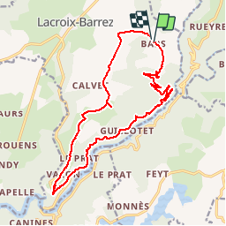
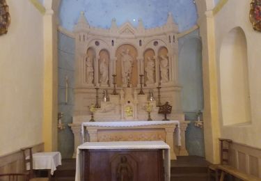
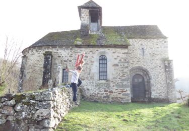
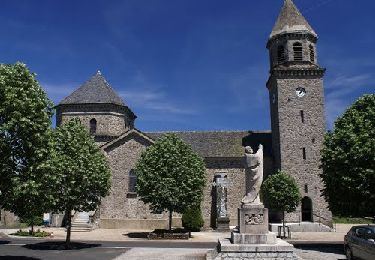
Randonnée Marche de 18,6 km à découvrir à Occitanie, Aveyron, Lacroix-Barrez. Cette randonnée est proposée par destras.

Description

Passage par les belvédères de Bars et de Fraysse  

Profil altimétrique

Photos

Points d'intérêt

Point d'intérêt Lacroix-Barrez - Eglise de Bars - Photo
destras
LACROIX-BARREZ 
Point d'intérêt Lacroix-Barrez - Taureau  - Photo
destras
LACROIX-BARREZ 

Localisation

Pays :
France
Région :
Occitanie
Département/Province :
Aveyron
Commune :
Lacroix-Barrez
Localité :
Unknown
Départ:(Dec)
Départ:(UTM)
473850 ; 4957994 (31T) N.

Commentaires

Veuillez vous connecter pour laisser un commentaire ou une note


Randonnées à proximité

Randonnée A pied Montézic - Saut du Chien - Photo
A pied
PRO

A pied

Facile
Montézic, Occitanie, Aveyron, France
4,2 km | 5,8 km-effort
1h 18min
Non
Randonnée Marche Lacroix-Barrez - Chateau Vallon au depart de Bars  - Photo
Marche
tercla

Marche

Moyen
Lacroix-Barrez, Occitanie, Aveyron, France
19,2 km | 27 km-effort
6h 31min
Oui
Randonnée Vélo Taussac - Tour des ruisseaux du Goul et de l'Embernat - Photo
Vélo
destras

Vélo

Difficile
Taussac, Occitanie, Aveyron, France
47 km | 61 km-effort
3h 1min
Oui
Randonnée Marche Taussac - le tour du ruisseau d'Embernat - Photo
Marche
destras

Marche

Moyen
Taussac, Occitanie, Aveyron, France
21 km | 27 km-effort
5h 48min
Oui
Randonnée Marche Saint-Symphorien-de-Thénières - 12_saint_gervais_valon_dilhac_2024 - Photo
Marche
jab31

Marche

Très difficile
Saint-Symphorien-de-Thénières, Occitanie, Aveyron, France
17,3 km | 25 km-effort
5h 41min
Non
Randonnée Marche Saint-Symphorien-de-Thénières - 12_saint-gervais_valon_2024 - Photo
Marche
jab31

Marche

Très difficile
Saint-Symphorien-de-Thénières, Occitanie, Aveyron, France
19,3 km | 29 km-effort
6h 41min
Non
Randonnée Marche Lacroix-Barrez - 12_valon_ginolhac_2024 - Photo
Marche
jab31

Marche

Très difficile
Lacroix-Barrez, Occitanie, Aveyron, France
21 km | 34 km-effort
7h 39min
Non
Randonnée Marche Lacroix-Barrez - Vallon, les gorges de la Thruyère - Photo
Marche
jocelyneviel

Marche

Moyen
Lacroix-Barrez, Occitanie, Aveyron, France
8,3 km | 13,3 km-effort
2h 41min
Oui
Randonnée Marche Lacroix-Barrez - bars vilherols aveyron  - Photo
Marche
josy31

Marche

Facile
Lacroix-Barrez, Occitanie, Aveyron, France
4,6 km | 6,4 km-effort
1h 39min
Oui


Fermer
Mes abonnements