Randonnée Marche Perpignan - 66 Perpignan Panchot centre bas Vernet centre del mon - Photo

66 Perpignan Panchot centre bas Vernet centre del mon

 jeff66
jeff66

Utilisateur

© OpenStreetMap contributors
Longueur
Longueur
8,6 km
Altitude max
Altitude max
50 m
Dénivelé positif
Dénivelé positif
59 m
Km-Effort
Km-Effort  
9,3 km
Altitude min
Altitude min
24 m
Dénivelé négatif
Dénivelé négatif
58 m
Boucle
Boucle
Oui
Date de création :
2016-03-14 00:00:00.0
Dernière modification :
2016-03-14 00:00:00.0

(0 Avis)

Marche
Marche
1h29
Difficulté : Facile

Scannez ce code QR pour ouvrir la randonnée dans l'application SityTrail

Application GPS de randonnée GRATUITE

Logo SityTrail SityTrail

IGN / Instituts géographiques

Télécharger SityTrail sur l'App Store Télécharger SityTrail sur Google Play

Logo SityTrail SityTrail World

Le monde est à vous

Télécharger SityTrail sur l'App Store Télécharger SityTrail sur Google Play Télécharger SityTrail sur Huawei AppGallery

À propos

Randonnée Marche de 8,6 km à découvrir à Occitanie, Pyrénées-Orientales, Perpignan. Cette randonnée est proposée par jeff66.

Description

66 PERPIGNAN, av. J.Panchot à proximité du stade J.Lafon, Av. P.Doumer, quais A.Nobel - P.Bourdan - S.Vauban, Places G.Peri et Bardou Job, rue Dr Pous, rues remparts Villeneuve - G.Flaubert, Theatre de l'Archipel, Bld L.Torcatis, rues M.desbores-valmor - ancien Champ de   Mars - G. Bizet -J.Aicard - Beausoleil, Ch. du sacré cœur, rues Beausoleil - J.M. De Heredia - H.Despres, Bld Desnoyes, rues À.Talut - des pêcheurs, place de Catalogne, av. du Gal de Gaulle, itinéraire piétons, imp. Du poète, rue M. Regnier, Bld du Conflent, gare centre del mon, rue J.N. Sarda-Garriga, retour av. J. Panchot

Profil altimétrique

Photos

Localisation

Pays :
France
Région :
Occitanie
Département/Province :
Pyrénées-Orientales
Commune :
Perpignan
Localité :
Unknown
Départ:(Dec)
Départ:(UTM)
489952 ; 4726272 (31T) N.

Randonnées à proximité

Randonnée Marche Saint-Estève - SAINT-ESTEVE 66 - ballade dans le Vignoble de Rivesaltes  - Photo
Marche
jeff66

Marche

Moyen
(1)
Saint-Estève, Occitanie, Pyrénées-Orientales, France
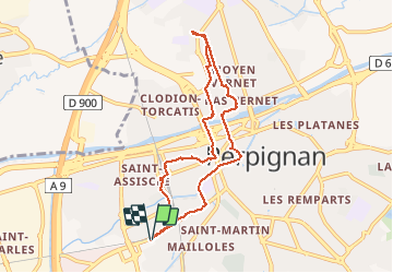
8 km | 8,8 km-effort
1h 23min
Oui
Randonnée Marche Cabestany - Chemins autour de Cabestany - Photo
Marche
tracegps

Marche

Moyen
(2)
Cabestany, Occitanie, Pyrénées-Orientales, France
11,8 km | 12,7 km-effort
3h 0min
Oui
Randonnée Marche Perpignan - Perpignan 01.10.2017  - Photo
Marche
jeff66

Marche

Facile
(1)
Perpignan, Occitanie, Pyrénées-Orientales, France
6,7 km | 7,5 km-effort
1h 39min
Non
Randonnée V.T.T. Canohès - canohes - Photo
V.T.T.
haroldtheviking

V.T.T.

Moyen
(2)
Canohès, Occitanie, Pyrénées-Orientales, France
37 km | 44 km-effort
2h 12min
Oui
Randonnée Quad Villeneuve-de-la-Raho -  Villeneuve-de-la-Raho-Collioure (Septembre/Juin) - Photo
Quad
Quad Ride

Quad

Moyen
(1)
Villeneuve-de-la-Raho, Occitanie, Pyrénées-Orientales, France
44 km | 51 km-effort
1h 45min
Non
Randonnée Marche Perpignan - Perpignan  - Photo
Marche
ombrabella

Marche

Très facile
Perpignan, Occitanie, Pyrénées-Orientales, France
18 km | 19,9 km-effort
2h 23min
Non
Randonnée Marche Perpignan - canal Perpignan  - Photo
Marche
Fildesir

Marche

Très facile
Perpignan, Occitanie, Pyrénées-Orientales, France
25 km | 27 km-effort
7h 29min
Non
Randonnée Marche Perpignan - 66 PERPIGNAN, quartier MAV au Bas Vernet  - Photo
Marche
jeff66

Marche

Facile
Perpignan, Occitanie, Pyrénées-Orientales, France
10,7 km | 11,8 km-effort
1h 45min
Oui
Randonnée Marche Bompas - 66 BOMPAS - itinéraire partagé piétions cycliste en bord de Tet, berge Têt, Bas Vernet, retour par les canaux et centre ville de BOMPAS  - Photo
Marche
jeff66

Marche

Moyen
Bompas, Occitanie, Pyrénées-Orientales, France
13,4 km | 14,2 km-effort
2h 23min
Oui


Fermer
Mes abonnements