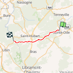
Randonnée Cheval Sainte-Ode - Etape 4 St Ode-Poix St Hubert - Photo

Etape 4 St Ode-Poix St Hubert

 CrisDjazzy
CrisDjazzy

Utilisateur

© OpenStreetMap contributors
Longueur
Longueur
19,3 km
Altitude max
Altitude max
565 m
Dénivelé positif
Dénivelé positif
401 m
Km-Effort
Km-Effort  
25 km
Altitude min
Altitude min
340 m
Dénivelé négatif
Dénivelé négatif
448 m
Boucle
Boucle
Non
Date de création :
01/06/2016 00:00
Dernière modification :
01/06/2016 00:00

(0 Avis)

Cheval
Cheval
3h03
Difficulté : Moyen

Scannez ce code QR pour ouvrir la randonnée dans l'application SityTrail

Application GPS de randonnée GRATUITE

Logo SityTrail SityTrail

IGN / Instituts géographiques

Télécharger SityTrail sur l'App Store Télécharger SityTrail sur Google Play

Logo SityTrail SityTrail Plus

Le monde est à vous

Télécharger SityTrail sur l'App Store Télécharger SityTrail sur Google Play Télécharger SityTrail sur Huawei AppGallery

À propos

Randonnée Cheval de 19,3 km à découvrir à Wallonie, Luxembourg, Sainte-Ode. Cette randonnée est proposée par CrisDjazzy.

Description

St Ode- Poix St Hubert

Profil altimétrique

Localisation

Pays :
Belgique
Région :
Wallonie
Département/Province :
Luxembourg
Commune :
Sainte-Ode
Localité :
Lavacherie
Départ:(Dec)
Départ:(UTM)
680020 ; 5546163 (31U) N.


Fermer
Mes abonnements