![](/images/other/stat-length.png)
![Randonnée Marche Poulan-Pouzols - Poulan Trincou - Photo](https://media.geolcdn.com/t/1900/400/ext.pjpeg?maxdim=2&url=https%3A%2F%2Fstatic1.geolcdn.com%2Fsiteimages%2Fupload%2Ffiles%2F1553511878bg_sport_marche.png)
Poulan Trincou
jpipacific
Utilisateur
![Longueur](/images/other/stat-length.png)
Longueur
6,9 km
![Altitude max](https://static1.geolcdn.com/siteimages/upload/files/1508320355ic_sort_altitude_max_24dp.png)
Altitude max
278 m
![Dénivelé positif](https://static1.geolcdn.com/siteimages/upload/files/1508320355ic_sort_den_pos_24dp.png)
Dénivelé positif
155 m
![Km-Effort](/images/other/stat-length.png)
Km-Effort
9 km
![Altitude min](https://static1.geolcdn.com/siteimages/upload/files/1508320355ic_sort_altitude_min_24dp.png)
Altitude min
207 m
![Dénivelé négatif](https://static1.geolcdn.com/siteimages/upload/files/1508320355ic_sort_den_neg_24dp.png)
Dénivelé négatif
154 m
![Boucle](https://static1.geolcdn.com/siteimages/upload/files/16400158638029165_repeat_loop_refresh_sync_direction_icon.png)
Boucle
Oui
Date de création :
2016-06-30 00:00:00.0
Dernière modification :
2016-06-30 00:00:00.0
![Marche](https://static1.geolcdn.com/sitytour/trail-icons/101.png)
1h56
Difficulté : Très facile
![Scannez ce code QR pour ouvrir la randonnée dans l'application SityTrail](https://capi.geolives.com/qq0zvz2zws4bq2lad0pu/sitytour/trails/589718/qr.png?size=200)
Application GPS de randonnée GRATUITE
À propos
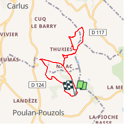
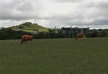
Randonnée Marche de 6,9 km à découvrir à Occitanie, Tarn, Poulan-Pouzols. Cette randonnée est proposée par jpipacific.
Description
petite randonnée de mise en jambes
Après Les fargues le chemin est plus ou moins privé et trés mal marqué jusqu'à l'arrivée.
Localisation
Pays :
France
Région :
Occitanie
Département/Province :
Tarn
Commune :
Poulan-Pouzols
Localité :
Unknown
Départ:(Dec)
Départ:(UTM)
430111 ; 4857107 (31T) N.
Commentaires
Randonnées à proximité
![Randonnée Marche Orban - SityTrail - 3061378 - orban-chemin-des-cretes - Photo](https://media.geolcdn.com/t/375/260/ext.jpg?maxdim=2&url=https%3A%2F%2Fmedia.geolcdn.com%2Ff%2F26a0c344-fd25-47d2-a26d-446f19e423e5.jpg)
![Marche Marche](https://static1.geolcdn.com/sitytour/trail-icons/101.png)
SityTrail - 3061378 - orban-chemin-des-cretes
Marche
Moyen
Orban,
Occitanie,
Tarn,
France
![](/images/other/stat-length.png)
5,9 km | 7,5 km-effort
1h 42min
![](https://static1.geolcdn.com/siteimages/upload/files/16400158638029165_repeat_loop_refresh_sync_direction_icon.png)
Oui
![Randonnée V.T.T. Rouffiac - Circuit du Puech de Mourens - Rouffiac - Photo](https://media.geolcdn.com/t/375/260/ext.jpg?maxdim=2&url=https%3A%2F%2Fservices.sitytrail.com%2FGeolivesWS%2FDownloadMedia.ashx%3FTrailID%3D104295%26Media%3D7522_3.jpg)
![V.T.T. V.T.T.](https://static1.geolcdn.com/sitytour/trail-icons/202.png)
Circuit du Puech de Mourens - Rouffiac
V.T.T.
Facile
Rouffiac,
Occitanie,
Tarn,
France
![](/images/other/stat-length.png)
9,5 km | 11,8 km-effort
45min
![](https://static1.geolcdn.com/siteimages/upload/files/16400158638029165_repeat_loop_refresh_sync_direction_icon.png)
Oui
![Randonnée Marche Rouffiac - Circuit du Puech de Mourens - Rouffiac - Photo](https://media.geolcdn.com/t/375/260/ext.jpg?maxdim=2&url=https%3A%2F%2Fservices.sitytrail.com%2FGeolivesWS%2FDownloadMedia.ashx%3FTrailID%3D104294%26Media%3D7522_3.jpg)
![Marche Marche](https://static1.geolcdn.com/sitytour/trail-icons/101.png)
Circuit du Puech de Mourens - Rouffiac
Marche
Moyen
(1)
Rouffiac,
Occitanie,
Tarn,
France
![](/images/other/stat-length.png)
9,5 km | 11,8 km-effort
2h 19min
![](https://static1.geolcdn.com/siteimages/upload/files/16400158638029165_repeat_loop_refresh_sync_direction_icon.png)
Oui
![Randonnée Marche Rouffiac - Rouffiac Puech Mourens - Photo](https://media.geolcdn.com/t/375/260/ext.jpg?maxdim=2&url=https%3A%2F%2Fmedia.geolcdn.com%2Ff%2Fa9abe737-8dff-496f-8677-03b7bc427dde.jpg)
![Marche Marche](https://static1.geolcdn.com/sitytour/trail-icons/101.png)
Rouffiac Puech Mourens
Marche
Très facile
Rouffiac,
Occitanie,
Tarn,
France
![](/images/other/stat-length.png)
9,6 km | 11,8 km-effort
2h 24min
![](https://static1.geolcdn.com/siteimages/upload/files/16400158638029165_repeat_loop_refresh_sync_direction_icon.png)
Oui
![Randonnée Marche Puygouzon - Sentier des Panoramas court - Photo](https://media.geolcdn.com/t/375/260/ext.jpg?maxdim=2&url=https%3A%2F%2Fservices.sitytrail.com%2FGeolivesWS%2FDownloadMedia.ashx%3FTrailID%3D824146%26Media%3Dfix__20170906112343.jpg)
![Marche Marche](https://static1.geolcdn.com/sitytour/trail-icons/101.png)
Sentier des Panoramas court
Marche
Facile
Puygouzon,
Occitanie,
Tarn,
France
![](/images/other/stat-length.png)
8 km | 10,2 km-effort
1h 50min
![](https://static1.geolcdn.com/siteimages/upload/files/16400158638029165_repeat_loop_refresh_sync_direction_icon.png)
Oui
![Randonnée A pied Lombers - Saint Pierre de Conils - Photo](https://media.geolcdn.com/t/375/260/ext.jpg?maxdim=2&url=https%3A%2F%2Fstatic1.geolcdn.com%2Fsiteimages%2Fupload%2Ffiles%2F1545311037marcheuse_200dpi.jpg)
![A pied A pied](https://static1.geolcdn.com/sitytour/trail-icons/100.png)
Saint Pierre de Conils
A pied
Facile
Lombers,
Occitanie,
Tarn,
France
![](/images/other/stat-length.png)
13,1 km | 15,7 km-effort
3h 34min
![](https://static1.geolcdn.com/siteimages/upload/files/16400158638029165_repeat_loop_refresh_sync_direction_icon.png)
Oui
![Randonnée Marche Poulan-Pouzols - Pouzols - Photo](https://media.geolcdn.com/t/375/260/ext.jpg?maxdim=2&url=https%3A%2F%2Fstatic1.geolcdn.com%2Fsiteimages%2Fupload%2Ffiles%2F1553511878bg_sport_marche.png)
![Marche Marche](https://static1.geolcdn.com/sitytour/trail-icons/101.png)
Pouzols
Marche
Difficile
Poulan-Pouzols,
Occitanie,
Tarn,
France
![](/images/other/stat-length.png)
12,9 km | 15,4 km-effort
3h 29min
![](https://static1.geolcdn.com/siteimages/upload/files/16400158638029165_repeat_loop_refresh_sync_direction_icon.png)
Oui
![Randonnée Marche Lombers - archeologue variante - Photo](https://media.geolcdn.com/t/375/260/ext.jpg?maxdim=2&url=https%3A%2F%2Fstatic1.geolcdn.com%2Fsiteimages%2Fupload%2Ffiles%2F1553511878bg_sport_marche.png)
![Marche Marche](https://static1.geolcdn.com/sitytour/trail-icons/101.png)
archeologue variante
Marche
Difficile
Lombers,
Occitanie,
Tarn,
France
![](/images/other/stat-length.png)
10,7 km | 12,8 km-effort
2h 16min
![](https://static1.geolcdn.com/siteimages/upload/files/16400158638029165_repeat_loop_refresh_sync_direction_icon.png)
Oui
![Randonnée Course à pied Lombers - St PIerre Lombers via sentier des Romains - Photo](https://media.geolcdn.com/t/375/260/ext.jpg?maxdim=2&url=https%3A%2F%2Fstatic1.geolcdn.com%2Fsiteimages%2Fupload%2Ffiles%2F1524743154running.jpg)
![Course à pied Course à pied](https://static1.geolcdn.com/sitytour/trail-icons/103.png)
St PIerre Lombers via sentier des Romains
Course à pied
Très facile
(2)
Lombers,
Occitanie,
Tarn,
France
![](/images/other/stat-length.png)
11,7 km | 14 km-effort
Inconnu
![](https://static1.geolcdn.com/siteimages/upload/files/16400158638029165_repeat_loop_refresh_sync_direction_icon.png)
Oui