Randonnée Marche Saint-Antonin-sur-Bayon - Tour de la Sainte Victoire - Photo
 Baltykatt
Baltykatt

Utilisateur

© OpenStreetMap contributors
Longueur
Longueur
20 km
Altitude max
Altitude max
1014 m
Dénivelé positif
Dénivelé positif
1484 m
Km-Effort
Km-Effort  
40 km
Altitude min
Altitude min
303 m
Dénivelé négatif
Dénivelé négatif
1478 m
Boucle
Boucle
Oui
Date de création :
2015-01-18 00:00:00.0
Dernière modification :
2015-01-18 00:00:00.0

(1 Avis)

Marche
Marche
8h00
Difficulté : Moyen

Scannez ce code QR pour ouvrir la randonnée dans l'application SityTrail

Application GPS de randonnée GRATUITE

Logo SityTrail SityTrail

IGN / Instituts géographiques

Télécharger SityTrail sur l'App Store Télécharger SityTrail sur Google Play

Logo SityTrail SityTrail World

Le monde est à vous

Télécharger SityTrail sur l'App Store Télécharger SityTrail sur Google Play Télécharger SityTrail sur Huawei AppGallery

À propos

Randonnée Marche de 20 km à découvrir à Provence-Alpes-Côte d'Azur, Bouches-du-Rhône, Saint-Antonin-sur-Bayon. Cette randonnée est proposée par Baltykatt.

Profil altimétrique

Localisation

Pays :
France
Région :
Provence-Alpes-Côte d'Azur
Département/Province :
Bouches-du-Rhône
Commune :
Saint-Antonin-sur-Bayon
Localité :
Unknown
Départ:(Dec)
Départ:(UTM)
707286 ; 4822177 (31T) N.

Commentaires

Veuillez vous connecter pour laisser un commentaire ou une note


Très jolie randonnée, la descente après le pic des mouches sur la droite est cependant longue et dangereuse pour les randonneurs non avertis.


Randonnées à proximité

Randonnée Marche Saint-Antonin-sur-Bayon - Ste Victoire - Le Garagaï - Photo
Marche
ETMU5496

Marche

Difficile
(1)
Saint-Antonin-sur-Bayon, Provence-Alpes-Côte d'Azur, Bouches-du-Rhône, France
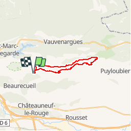
15,8 km | 28 km-effort
4h 36min
Oui
Randonnée Marche Saint-Marc-Jaumegarde - Barrages Zola-Bimont - Photo
Marche
Berpav

Marche

Moyen
(2)
Saint-Marc-Jaumegarde, Provence-Alpes-Côte d'Azur, Bouches-du-Rhône, France
8 km | 11 km-effort
2h 30min
Oui
Randonnée Marche Vauvenargues - Le Signal, Montagne Sainte-Victoire - Photo
Marche
tracegps

Marche

Moyen
(2)
Vauvenargues, Provence-Alpes-Côte d'Azur, Bouches-du-Rhône, France
15 km | 25 km-effort
6h 19min
Oui
Randonnée Marche Saint-Marc-Jaumegarde - La Croix de Provence depuis le barrage de Bimont - Photo
Marche
tracegps

Marche

Difficile
(1)
Saint-Marc-Jaumegarde, Provence-Alpes-Côte d'Azur, Bouches-du-Rhône, France
13,9 km | 24 km-effort
4h 45min
Oui
Randonnée Marche Saint-Antonin-sur-Bayon - 2023-02-10 Sainte Victoire Bau des Vespres - Photo
Marche
GUIDE
Kargil

Marche

Difficile
Saint-Antonin-sur-Bayon, Provence-Alpes-Côte d'Azur, Bouches-du-Rhône, France
10 km | 18,8 km-effort
3h 30min
Oui
Randonnée A pied Vauvenargues - Sentier des Venturiers - Photo
A pied
PRO

A pied

Facile
Vauvenargues, Provence-Alpes-Côte d'Azur, Bouches-du-Rhône, France
5 km | 10,5 km-effort
2h 23min
Non
Randonnée A pied Beaurecueil - Sentier Imoucha - Photo
A pied
PRO

A pied

Facile
Beaurecueil, Provence-Alpes-Côte d'Azur, Bouches-du-Rhône, France
4,4 km | 10,1 km-effort
2h 17min
Non
Randonnée Marche Saint-Antonin-sur-Bayon - pas du clapier et tracé vert - Photo
Marche
GUIDE
amiral13

Marche

Difficile
Saint-Antonin-sur-Bayon, Provence-Alpes-Côte d'Azur, Bouches-du-Rhône, France
10,5 km | 21 km-effort
5h 24min
Oui
Randonnée Marche Saint-Antonin-sur-Bayon - Sainte Victoire - Bau Cézanne - tracé jaune - Photo
Marche
GUIDE
amiral13

Marche

Difficile
(1)
Saint-Antonin-sur-Bayon, Provence-Alpes-Côte d'Azur, Bouches-du-Rhône, France
5,3 km | 12,2 km-effort
2h 28min
Oui


Fermer
Mes abonnements