23 km | 36 km-effort
Le Gaschney 2017 - 1
arnold.jacobs
Utilisateur
Longueur
13,6 km
Altitude max
1350 m
Dénivelé positif
676 m
Km-Effort
23 km
Altitude min
801 m
Dénivelé négatif
678 m
Boucle
Oui
Date de création :
2016-12-22 00:00:00.0
Dernière modification :
2019-08-10 15:11:58.839
5h00
Difficulté : Inconnu
Application GPS de randonnée GRATUITE
À propos
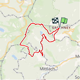
Randonnée Raquettes à neige de 13,6 km à découvrir à Grand Est, Haut-Rhin, Muhlbach-sur-Munster. Cette randonnée est proposée par arnold.jacobs.
Description
Rando raquettes et fauteuil ski
Localisation
Pays :
France
Région :
Grand Est
Département/Province :
Haut-Rhin
Commune :
Muhlbach-sur-Munster
Localité :
Unknown
Départ:(Dec)
Départ:(UTM)
354260 ; 5321943 (32U) N.
Commentaires
Randonnées à proximité
2023-04-16 Marche Abri Lac de Blanchemer vers Lac de Lispach
Marche
Très difficile
(1)
La Bresse,
Grand Est,
Vosges,
France
8h 4min
Non
Tour du belvedere avec le passage sur les crêtes
Marche
Très facile
(2)
Stosswihr,
Grand Est,
Haut-Rhin,
France
8,5 km | 0 m-effort
2h 28min
Oui
Kastelberg des pierres, des lacs, des panoramas magnifiques
Marche
Difficile
(1)
La Bresse,
Grand Est,
Vosges,
France
15,1 km | 26 km-effort
6h 11min
Oui
Les Hirschsteine
Marche
Difficile
(1)
Le Valtin,
Grand Est,
Vosges,
France
16,1 km | 25 km-effort
6h 28min
Oui
Du Hohneck au Kastelberg par les Spietzkoepfe et le Sentier des Névées
Marche
Très difficile
(3)
La Bresse,
Grand Est,
Vosges,
France
7,6 km | 13,7 km-effort
3h 30min
Oui
Rainkopf - Mittlach - Hohneck
Marche
Difficile
(1)
La Bresse,
Grand Est,
Vosges,
France
22 km | 41 km-effort
8h 0min
Oui
raquettes
Raquettes à neige
Très facile
(1)
Le Valtin,
Grand Est,
Vosges,
France
6,6 km | 9,4 km-effort
3h 8min
Non
Sentier des Névés
V.T.T.
Très difficile
(1)
Metzeral,
Grand Est,
Haut-Rhin,
France
33 km | 52 km-effort
6h 0min
Oui
Le cirque glaciaire du Frankenthal - Sentier des Roches -Gps
Marche
Difficile
(3)
Stosswihr,
Grand Est,
Haut-Rhin,
France
9 km | 16,1 km-effort
4h 10min
Oui