Randonnée V.T.T. Agen-d'Aveyron - Les Palanges 2 - Photo
 bonnetchristian
bonnetchristian

Utilisateur

© OpenStreetMap contributors
Longueur
Longueur
13,2 km
Altitude max
Altitude max
898 m
Dénivelé positif
Dénivelé positif
252 m
Km-Effort
Km-Effort  
16,6 km
Altitude min
Altitude min
786 m
Dénivelé négatif
Dénivelé négatif
249 m
Boucle
Boucle
Oui
Date de création :
2014-12-10 00:00:00.0
Dernière modification :
2014-12-10 00:00:00.0

(0 Avis)

V.T.T.
V.T.T.
--
Difficulté : Inconnu

Scannez ce code QR pour ouvrir la randonnée dans l'application SityTrail

Application GPS de randonnée GRATUITE

Logo SityTrail SityTrail

IGN / Instituts géographiques

Télécharger SityTrail sur l'App Store Télécharger SityTrail sur Google Play

Logo SityTrail SityTrail World

Le monde est à vous

Télécharger SityTrail sur l'App Store Télécharger SityTrail sur Google Play Télécharger SityTrail sur Huawei AppGallery

À propos

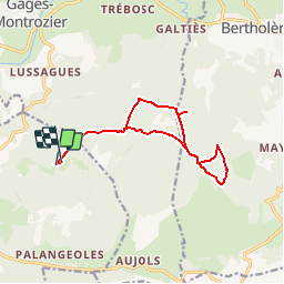
Randonnée V.T.T. de 13,2 km à découvrir à Occitanie, Aveyron, Agen-d'Aveyron. Cette randonnée est proposée par bonnetchristian.

Description

En forêt, terrain variable,
envisager risque de crevaison
sur terrain " naturel "....

Profil altimétrique

Localisation

Pays :
France
Région :
Occitanie
Département/Province :
Aveyron
Commune :
Agen-d'Aveyron
Localité :
Unknown
Départ:(Dec)
Départ:(UTM)
477186 ; 4912313 (31T) N.

Randonnées à proximité

Randonnée Moto-cross Montrozier - av cl 2024 - Photo
Moto-cross
frank12

Moto-cross

Très facile
Montrozier, Occitanie, Aveyron, France
30 km | 42 km-effort
1h 0min
Non
Randonnée V.T.T. Montrozier - VTT  de Gages à la forêt des Palanges 38km  - Photo
V.T.T.
Levillefranchois

V.T.T.

Moyen
Montrozier, Occitanie, Aveyron, France
38 km | 47 km-effort
Inconnu
Oui
Randonnée Marche Montrozier - Gages Campeyroux - Photo
Marche
Rere1947

Marche

Montrozier, Occitanie, Aveyron, France
8,4 km | 9,7 km-effort
1h 52min
Oui
Randonnée V.T.T. Bertholène - ancienne voie ferrée - Photo
V.T.T.
bbertrand974

V.T.T.

Très facile
Bertholène, Occitanie, Aveyron, France
22 km | 26 km-effort
1h 42min
Non
Randonnée V.T.T. Montrozier - Gages - Photo
V.T.T.
bonnetchristian

V.T.T.

Très facile
Montrozier, Occitanie, Aveyron, France
4,7 km | 6 km-effort
Inconnu
Oui
Randonnée Marche La Loubière - Ortholes - Canabols - Photo
Marche
bonnetchristian

Marche

Très facile
La Loubière, Occitanie, Aveyron, France
8,4 km | 10 km-effort
Inconnu
Oui
Randonnée V.T.T. Agen-d'Aveyron - Les Palanges 1 - Photo
V.T.T.
bonnetchristian

V.T.T.

Très facile
(1)
Agen-d'Aveyron, Occitanie, Aveyron, France
10 km | 12,4 km-effort
Inconnu
Oui
Randonnée V.T.T. La Loubière - Campeyroux - Photo
V.T.T.
bonnetchristian

V.T.T.

Très facile
La Loubière, Occitanie, Aveyron, France
5 km | 5,8 km-effort
Inconnu
Oui
Randonnée Moto-cross Montrozier - essai av. cl.2024 - Photo
Moto-cross
frank12

Moto-cross

Très facile
Montrozier, Occitanie, Aveyron, France
26 km | 0 m-effort
1h 7min
Non


Fermer
Mes abonnements