


LA BUTTE A CHÉRON

laoj
Utilisateur
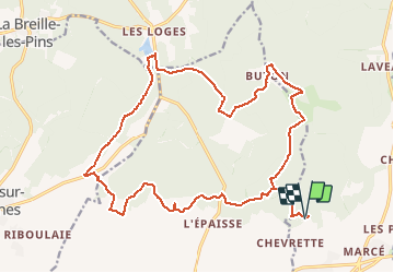

Longueur
23 km

Altitude max
123 m

Dénivelé positif
331 m
Km-Effort
27 km

Altitude min
44 m

Dénivelé négatif
334 m
Boucle
Oui
Date de création :
2017-03-13 00:00:00.0
Dernière modification :
2017-03-13 00:00:00.0
1h47
Difficulté : Moyen

Application GPS de randonnée GRATUITE
 SityTrail
IGN / Instituts géographiques
SityTrail Plus
Le monde est à vous
À propos
Randonnée V.T.T. de 23 km à découvrir à Centre-Val de Loire, Indre-et-Loire, Bourgueil. Cette randonnée est proposée par laoj.
Description
DÉPART DU MOULIN BLEU
CIRCUIT ALL MOUNTAIN ENTRE COTEAUX ET FORET.
UNE GROSSE BOUFFÉE D'OXYGENE !
Localisation
Pays :
France
Région :
Centre-Val de Loire
Département/Province :
Indre-et-Loire
Commune :
Bourgueil
Localité :
Unknown
Départ:(Dec)
Départ:(UTM)
285598 ; 5242438 (31T) N.
Commentaires
que du bonheur !