


RP66 ARGELES PLAGE - PORT ARGELES - LE RACOU - le 18.04.2017

jeff66
Utilisateur
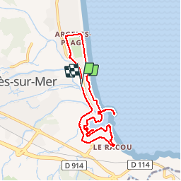

Longueur
8,4 km

Altitude max
8 m

Dénivelé positif
34 m
Km-Effort
8,8 km

Altitude min
-1 m

Dénivelé négatif
34 m
Boucle
Oui
Date de création :
2017-04-18 00:00:00.0
Dernière modification :
2017-04-18 00:00:00.0
1h36
Difficulté : Facile

Application GPS de randonnée GRATUITE
 SityTrail
IGN / Instituts géographiques
SityTrail Plus
Le monde est à vous
À propos
Randonnée Marche de 8,4 km à découvrir à Occitanie, Pyrénées-Orientales, Argelès-sur-Mer. Cette randonnée est proposée par jeff66.
Description
RP66 ARGELES PLAGE - PORT ARGELES - LE RACOU - le 18.04.2017
Localisation
Pays :
France
Région :
Occitanie
Département/Province :
Pyrénées-Orientales
Commune :
Argelès-sur-Mer
Localité :
Unknown
Départ:(Dec)
Départ:(UTM)
503853 ; 4710667 (31T) N.
Commentaires