Randonnée Marche Saint-Amarin - Le grand ballon et son lac - Photo

Le grand ballon et son lac

 grattounette
grattounette

Utilisateur

© OpenStreetMap contributors
Longueur
Longueur
19,3 km
Altitude max
Altitude max
1420 m
Dénivelé positif
Dénivelé positif
1005 m
Km-Effort
Km-Effort  
33 km
Altitude min
Altitude min
704 m
Dénivelé négatif
Dénivelé négatif
1004 m
Boucle
Boucle
Oui
Date de création :
2017-05-29 00:00:00.0
Dernière modification :
2017-05-29 00:00:00.0

(0 Avis)

Marche
Marche
7h58
Difficulté : Difficile

Scannez ce code QR pour ouvrir la randonnée dans l'application SityTrail

Application GPS de randonnée GRATUITE

Logo SityTrail SityTrail

IGN / Instituts géographiques

Télécharger SityTrail sur l'App Store Télécharger SityTrail sur Google Play

Logo SityTrail SityTrail World

Le monde est à vous

Télécharger SityTrail sur l'App Store Télécharger SityTrail sur Google Play Télécharger SityTrail sur Huawei AppGallery

À propos

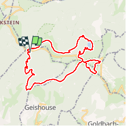
Randonnée Marche de 19,3 km à découvrir à Grand Est, Haut-Rhin, Saint-Amarin. Cette randonnée est proposée par grattounette.

Description

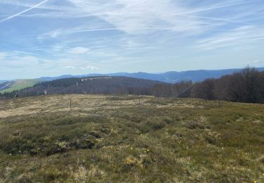
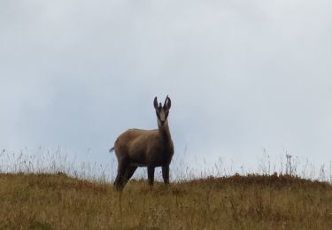
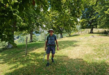
départ du Chalet SCSA,belle descente sur le sentier edelweiss, chapelle St Nicolas remonte par le GR 532 vers le col du Haag, bonne Grimpette pour monte au Grand Ballon, superbe point de vue à 360,  avec le monument des diables bleus et le Radar du Grand Ballon, redescendre par le col du Haag, traverse la D431 direction le lac du ballon puis retour vers Moorfeid par un ancien sentier difficile à trouver Simon suivre le GR 532 le long de la D 431

Profil altimétrique

Localisation

Pays :
France
Région :
Grand Est
Département/Province :
Haut-Rhin
Commune :
Saint-Amarin
Localité :
Unknown
Départ:(Dec)
Départ:(UTM)
354557 ; 5308046 (32T) N.

Randonnées à proximité

Randonnée Marche Linthal - Markstein - Photo
Marche
VacheKiri67

Marche

Moyen
(1)
Linthal, Grand Est, Haut-Rhin, France
14 km | 19,8 km-effort
4h 45min
Oui
Randonnée Marche Lautenbachzell - Le Markstein - Photo
Marche
tracegps

Marche

Difficile
(1)
Lautenbachzell, Grand Est, Haut-Rhin, France
22 km | 35 km-effort
6h 0min
Oui
Randonnée Marche Linthal - 68 Remspach - Hilsen - Photo
Marche

Marche

Moyen
(1)
Linthal, Grand Est, Haut-Rhin, France
9,9 km | 14,6 km-effort
3h 3min
Oui
Randonnée A pied Lautenbachzell - Parking Bellevue - Hundsrucken - Markstein - Photo
A pied
patrickbeyrath

A pied

Moyen
(1)
Lautenbachzell, Grand Est, Haut-Rhin, France
9,4 km | 13 km-effort
Inconnu
Oui
Randonnée V.T.T. Metzeral - Breitfirst - Petit Ballon - Col de Firstplan - Wintzenheim - Photo
V.T.T.
sit68000

V.T.T.

Moyen
(1)
Metzeral, Grand Est, Haut-Rhin, France
38 km | 52 km-effort
3h 11min
Non
Randonnée Marche Metzeral - 24 04 14 autour d’Uffrain - Photo
Marche
jmbilger

Marche

Metzeral, Grand Est, Haut-Rhin, France
70 km | 83 km-effort
3h 45min
Non
Randonnée Marche Soultz-Haut-Rhin - Mon tour des Vosges (4 jours) - Photo
Marche
annefrance70

Marche

Très difficile
Soultz-Haut-Rhin, Grand Est, Haut-Rhin, France
71 km | 113 km-effort
25h 38min
Oui
Randonnée Marche Ranspach - Rando des Marcheurs 20/07/2023 - Photo
Marche
boubou68

Marche

Très difficile
Ranspach, Grand Est, Haut-Rhin, France
23 km | 38 km-effort
5h 31min
Oui
Randonnée Marche Saint-Amarin - dimanche - Photo
Marche
Ninie38MD

Marche

Très difficile
(1)
Saint-Amarin, Grand Est, Haut-Rhin, France
19,4 km | 35 km-effort
7h 51min
Oui


Fermer
Mes abonnements