![](/images/other/stat-length.png)
![Randonnée V.T.T. Welkenraedt - Eu.WelkenraedtRoermond85A181.719.VTC - Photo](https://media.geolcdn.com/t/1900/400/ext.pjpeg?maxdim=2&url=https%3A%2F%2Fstatic1.geolcdn.com%2Fsiteimages%2Fupload%2Ffiles%2F1524743154velo.jpg)
Eu.WelkenraedtRoermond85A181.719.VTC
francois58
Utilisateur
![Longueur](/images/other/stat-length.png)
Longueur
181 km
![Altitude max](https://static1.geolcdn.com/siteimages/upload/files/1508320355ic_sort_altitude_max_24dp.png)
Altitude max
671 m
![Dénivelé positif](https://static1.geolcdn.com/siteimages/upload/files/1508320355ic_sort_den_pos_24dp.png)
Dénivelé positif
2036 m
![Km-Effort](/images/other/stat-length.png)
Km-Effort
209 km
![Altitude min](https://static1.geolcdn.com/siteimages/upload/files/1508320355ic_sort_altitude_min_24dp.png)
Altitude min
16 m
![Dénivelé négatif](https://static1.geolcdn.com/siteimages/upload/files/1508320355ic_sort_den_neg_24dp.png)
Dénivelé négatif
2275 m
![Boucle](https://static1.geolcdn.com/siteimages/upload/files/16400158638029165_repeat_loop_refresh_sync_direction_icon.png)
Boucle
Non
Date de création :
2017-08-09 00:00:00.0
Dernière modification :
2017-08-09 00:00:00.0
![V.T.T.](https://static1.geolcdn.com/sitytour/trail-icons/202.png)
13h03
Difficulté : Facile
![Scannez ce code QR pour ouvrir la randonnée dans l'application SityTrail](https://capi.geolives.com/qq0zvz2zws4bq2lad0pu/sitytour/trails/789034/qr.png?size=200)
Application GPS de randonnée GRATUITE
À propos
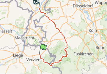
Randonnée V.T.T. de 181 km à découvrir à Wallonie, Liège, Welkenraedt. Cette randonnée est proposée par francois58.
Description
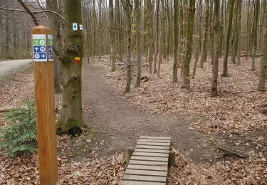
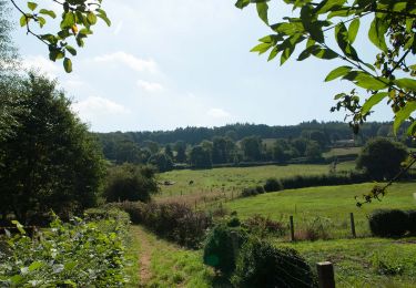
Randonnée très plaisante par sa variété (Forêt, Fagnes, Monschau, Rursee, ....
Bien sûr, il faut aimer "le long" ... mais la deuxième moitié est plate : cela compense !
La descente vers la Helle est un tout petit peu technique - mais tout le reste est type VTC !
Localisation
Pays :
Belgique
Région :
Wallonie
Département/Province :
Liège
Commune :
Welkenraedt
Localité :
Welkenraedt
Départ:(Dec)
Départ:(UTM)
709931 ; 5616536 (31U) N.
Commentaires
Randonnées à proximité
![Randonnée Marche Baelen - Baelen - Eupen 🎄🎅 - Membach - Photo](https://media.geolcdn.com/t/375/260/ext.jpg?maxdim=2&url=https%3A%2F%2Fmedia.geolcdn.com%2Ff%2Fd50227a7-424d-470e-90d5-87ebd384de36.jpg)
![Marche Marche](https://static1.geolcdn.com/sitytour/trail-icons/101.png)
Baelen - Eupen 🎄🎅 - Membach
Marche
Facile
(1)
Baelen,
Wallonie,
Liège,
Belgique
![](/images/other/stat-length.png)
13,3 km | 15,6 km-effort
3h 32min
![](https://static1.geolcdn.com/siteimages/upload/files/16400158638029165_repeat_loop_refresh_sync_direction_icon.png)
Oui
![Randonnée Marche Plombières - 20220428 - Bois de Hess 6.7 Km - Photo](https://media.geolcdn.com/t/375/260/ext.jpg?maxdim=2&url=https%3A%2F%2Fmedia.geolcdn.com%2Ff%2Fa5b9728a-379a-44f7-9b32-760730404ded.JPG)
![Marche Marche](https://static1.geolcdn.com/sitytour/trail-icons/101.png)
20220428 - Bois de Hess 6.7 Km
Marche
Moyen
(1)
Plombières,
Wallonie,
Liège,
Belgique
![](/images/other/stat-length.png)
6,7 km | 8,4 km-effort
3h 11min
![](https://static1.geolcdn.com/siteimages/upload/files/16400158638029165_repeat_loop_refresh_sync_direction_icon.png)
Oui
![Randonnée Marche Eupen - Autour d'Eupen - Photo](https://media.geolcdn.com/t/375/260/ext.jpg?maxdim=2&url=https%3A%2F%2Fmedia.geolcdn.com%2Ff%2F2e56e8e4-4348-489f-86b5-c8ca8af64230.jpg)
![Marche Marche](https://static1.geolcdn.com/sitytour/trail-icons/101.png)
Autour d'Eupen
Marche
Facile
(1)
Eupen,
Wallonie,
Liège,
Belgique
![](/images/other/stat-length.png)
13,3 km | 16,4 km-effort
3h 43min
![](https://static1.geolcdn.com/siteimages/upload/files/16400158638029165_repeat_loop_refresh_sync_direction_icon.png)
Oui
![Randonnée Marche Lontzen - Herbesthal - Photo](https://media.geolcdn.com/t/375/260/ext.jpg?maxdim=2&url=https%3A%2F%2Fmedia.geolcdn.com%2Ff%2Ff329bf39-b33b-4890-a8af-1e7d956ba015.jpg)
![Marche Marche](https://static1.geolcdn.com/sitytour/trail-icons/101.png)
Herbesthal
Marche
Facile
(2)
Lontzen,
Wallonie,
Liège,
Belgique
![](/images/other/stat-length.png)
13,4 km | 15,8 km-effort
3h 35min
![](https://static1.geolcdn.com/siteimages/upload/files/16400158638029165_repeat_loop_refresh_sync_direction_icon.png)
Oui
![Randonnée Marche Eupen - Eupen - Photo](https://media.geolcdn.com/t/375/260/ext.jpg?maxdim=2&url=https%3A%2F%2Fmedia.geolcdn.com%2Ff%2Fd87483d2-4d3d-461a-a9c9-ec45b2516003.jpg)
![Marche Marche](https://static1.geolcdn.com/sitytour/trail-icons/101.png)
![Randonnée Marche Limbourg - RL-GG-11_Dolhain-Gileppe_Pepinster - Photo](https://media.geolcdn.com/t/375/260/ext.jpg?maxdim=2&url=https%3A%2F%2Fmedia.geolcdn.com%2Ff%2F9cf2c240-5913-4088-b4f6-6c0e1fae0233.jpg)
![Marche Marche](https://static1.geolcdn.com/sitytour/trail-icons/101.png)
RL-GG-11_Dolhain-Gileppe_Pepinster
Marche
Très difficile
(2)
Limbourg,
Wallonie,
Liège,
Belgique
![](/images/other/stat-length.png)
20 km | 26 km-effort
5h 33min
![](https://static1.geolcdn.com/siteimages/upload/files/16400158638029165_repeat_loop_refresh_sync_direction_icon.png)
Non
![Randonnée Marche Welkenraedt - Promenade des deux Châteaux (5km) - Photo](https://media.geolcdn.com/t/375/260/ext.jpg?maxdim=2&url=https%3A%2F%2Fstatic1.geolcdn.com%2Fsiteimages%2Fupload%2Ffiles%2F1553511878bg_sport_marche.png)
![Marche Marche](https://static1.geolcdn.com/sitytour/trail-icons/101.png)
Promenade des deux Châteaux (5km)
Marche
Très facile
(2)
Welkenraedt,
Wallonie,
Liège,
Belgique
![](/images/other/stat-length.png)
5,4 km | 6 km-effort
Inconnu
![](https://static1.geolcdn.com/siteimages/upload/files/16400158638029165_repeat_loop_refresh_sync_direction_icon.png)
Oui
![Randonnée Marche Eupen - 20230723 - TOTEMUS Eupen - 8.4 Km - Photo](https://media.geolcdn.com/t/375/260/ext.jpg?maxdim=2&url=https%3A%2F%2Fmedia.geolcdn.com%2Ff%2F39403cab-430f-4ea7-9e1d-a590b78d82b5.jpeg)
![Marche Marche](https://static1.geolcdn.com/sitytour/trail-icons/101.png)
20230723 - TOTEMUS Eupen - 8.4 Km
Marche
Moyen
Eupen,
Wallonie,
Liège,
Belgique
![](/images/other/stat-length.png)
7,9 km | 9,5 km-effort
3h 1min
![](https://static1.geolcdn.com/siteimages/upload/files/16400158638029165_repeat_loop_refresh_sync_direction_icon.png)
Oui
![Randonnée Marche Plombières - 20220731 - Montzen - 8.7 Km - Photo](https://media.geolcdn.com/t/375/260/ext.jpg?maxdim=2&url=https%3A%2F%2Fmedia.geolcdn.com%2Ff%2F77a1be7c-cec6-4949-b04d-135cea679147.JPG)
![Marche Marche](https://static1.geolcdn.com/sitytour/trail-icons/101.png)
20220731 - Montzen - 8.7 Km
Marche
Moyen
Plombières,
Wallonie,
Liège,
Belgique
![](/images/other/stat-length.png)
8,7 km | 10,7 km-effort
6h 52min
![](https://static1.geolcdn.com/siteimages/upload/files/16400158638029165_repeat_loop_refresh_sync_direction_icon.png)
Oui