Randonnée V.T.T. Bouxwiller - Au départ de Bouxwiller - Photo

Au départ de Bouxwiller

 raydiez
raydiez

Utilisateur

© OpenStreetMap contributors
Longueur
Longueur
26 km
Altitude max
Altitude max
397 m
Dénivelé positif
Dénivelé positif
568 m
Km-Effort
Km-Effort  
33 km
Altitude min
Altitude min
177 m
Dénivelé négatif
Dénivelé négatif
573 m
Boucle
Boucle
Oui
Date de création :
2017-08-06 00:00:00.0
Dernière modification :
2017-08-06 00:00:00.0

(0 Avis)

V.T.T.
V.T.T.
--
Difficulté : Facile

Scannez ce code QR pour ouvrir la randonnée dans l'application SityTrail

Application GPS de randonnée GRATUITE

Logo SityTrail SityTrail

IGN / Instituts géographiques

Télécharger SityTrail sur l'App Store Télécharger SityTrail sur Google Play

Logo SityTrail SityTrail World

Le monde est à vous

Télécharger SityTrail sur l'App Store Télécharger SityTrail sur Google Play Télécharger SityTrail sur Huawei AppGallery

À propos

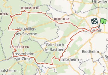
Randonnée V.T.T. de 26 km à découvrir à Grand Est, Bas-Rhin, Bouxwiller. Cette randonnée est proposée par raydiez.

Description

Bouxwiller, le batsberg, Griesbach, Neuwiller, le sentier du club vosgien balisé "rectangle bleu", puis "croix rouge" et retour

Profil altimétrique

Localisation

Pays :
France
Région :
Grand Est
Département/Province :
Bas-Rhin
Commune :
Bouxwiller
Localité :
Unknown
Départ:(Dec)
Départ:(UTM)
389057 ; 5409314 (32U) N.

Randonnées à proximité

Randonnée Marche Ingwiller - boucle Ingwiller /Lichtemberg - Photo
Marche
LUTZMarc

Marche

Moyen
Ingwiller, Grand Est, Bas-Rhin, France
20 km | 27 km-effort
5h 9min
Oui
Randonnée A pied Bouxwiller - Sentier Géologique / Sentier des Chortens - Photo
A pied
PRO

A pied

Facile
Bouxwiller, Grand Est, Bas-Rhin, France
5,8 km | 7,6 km-effort
1h 42min
Oui
Randonnée Marche Bouxwiller - Boucle Imbsheim Blastberg - Photo
Marche
zazie

Marche

Facile
Bouxwiller, Grand Est, Bas-Rhin, France
7,4 km | 9,3 km-effort
1h 51min
Oui
Randonnée Marche Bouxwiller - Boucle Imbsheim Blastberg - Photo
Marche
zazie

Marche

Facile
Bouxwiller, Grand Est, Bas-Rhin, France
7,4 km | 9,3 km-effort
1h 51min
Oui
Randonnée Marche Bouxwiller - sentier geologique du Batsberg - Photo
Marche
fbertrand

Marche

Moyen
Bouxwiller, Grand Est, Bas-Rhin, France
6 km | 7,8 km-effort
2h 31min
Oui
Randonnée Marche Bouxwiller - De Bouxwiller à Saverne - Photo
Marche
tracegps

Marche

Difficile
Bouxwiller, Grand Est, Bas-Rhin, France
21 km | 28 km-effort
5h 0min
Non
Randonnée Randonnée équestre Bouxwiller - griesbach Melsheim - Photo
Randonnée équestre
Mumu67330

Randonnée équestre

Très facile
Bouxwiller, Grand Est, Bas-Rhin, France
12,8 km | 14,8 km-effort
2h 26min
Non
Randonnée Marche Bouxwiller - Nouxwiller - Photo
Marche
bourdet

Marche

Très facile
Bouxwiller, Grand Est, Bas-Rhin, France
6,3 km | 7,8 km-effort
2h 32min
Oui
Randonnée Randonnée équestre Weiterswiller - remy - Photo
Randonnée équestre
Rémy Isenmann

Randonnée équestre

Difficile
Weiterswiller, Grand Est, Bas-Rhin, France
29 km | 38 km-effort
4h 59min
Oui


Fermer
Mes abonnements