Randonnée Marche Sainte-Cécile-d'Andorge - SAINTE CECILE D'ANDORGE - Chateau de Portes 18.7km 497m - Photo

SAINTE CECILE D'ANDORGE - Chateau de Portes 18.7km 497m

 ALDOMI30
ALDOMI30

Utilisateur

© OpenStreetMap contributors
Longueur
Longueur
18,7 km
Altitude max
Altitude max
630 m
Dénivelé positif
Dénivelé positif
497 m
Km-Effort
Km-Effort  
25 km
Altitude min
Altitude min
289 m
Dénivelé négatif
Dénivelé négatif
496 m
Boucle
Boucle
Oui
Date de création :
2017-09-13 00:00:00.0
Dernière modification :
2022-06-21 14:57:38.11

(1 Avis)

Marche
Marche
5h02
Difficulté : Difficile

Scannez ce code QR pour ouvrir la randonnée dans l'application SityTrail

Application GPS de randonnée GRATUITE

Logo SityTrail SityTrail

IGN / Instituts géographiques

Télécharger SityTrail sur l'App Store Télécharger SityTrail sur Google Play

Logo SityTrail SityTrail World

Le monde est à vous

Télécharger SityTrail sur l'App Store Télécharger SityTrail sur Google Play Télécharger SityTrail sur Huawei AppGallery

À propos

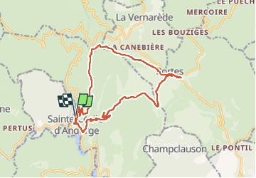
Randonnée Marche de 18,7 km à découvrir à Occitanie, Gard, Sainte-Cécile-d'Andorge. Cette randonnée est proposée par ALDOMI30.

Description

Portes

Profil altimétrique

Localisation

Pays :
France
Région :
Occitanie
Département/Province :
Gard
Commune :
Sainte-Cécile-d'Andorge
Localité :
Unknown
Départ:(Dec)
Départ:(UTM)
577907 ; 4900635 (31T) N.

Commentaires

Veuillez vous connecter pour laisser un commentaire ou une note


Randonnées à proximité

Randonnée A pied Le Collet-de-Dèze - Sentier de découverte de Tignac - Photo
A pied
PRO

A pied

Facile
Le Collet-de-Dèze, Occitanie, Lozère, France
3,6 km | 5,8 km-effort
1h 18min
Non
Randonnée Marche Portes - Portes à Ste Cécile  - Photo
Marche
GUIDE
nadinebondoux

Marche

Moyen
Portes, Occitanie, Gard, France
18,1 km | 25 km-effort
5h 25min
Non
Randonnée Marche Portes - Portes Sainte Cecile d ´Andorge - Photo
Marche
GUIDE
Roger Philippe Wallez

Marche

Très difficile
Portes, Occitanie, Gard, France
19,6 km | 26 km-effort
5h 34min
Oui
Randonnée Marche Portes - 220929_Portes - Photo
Marche
fario

Marche

Difficile
Portes, Occitanie, Gard, France
12,2 km | 16,6 km-effort
4h 54min
Oui
Randonnée Marche Portes - 220929_Portes - Photo
Marche
fario

Marche

Difficile
Portes, Occitanie, Gard, France
12,2 km | 16,6 km-effort
4h 54min
Oui
Randonnée A pied Le Collet-de-Dèze - PR Sentier de Molières - Photo
A pied
PRO

A pied

Facile
Le Collet-de-Dèze, Occitanie, Lozère, France
3,5 km | 4,7 km-effort
1h 4min
Non
Randonnée Marche Portes - portes mu - Photo
Marche
fario

Marche

Difficile
Portes, Occitanie, Gard, France
12,2 km | 16,6 km-effort
4h 54min
Oui
Randonnée Marche Sainte-Cécile-d'Andorge - SAINTE CÉCILE D'ANDORG - Photo
Marche
bernardgouttiere

Marche

Facile
Sainte-Cécile-d'Andorge, Occitanie, Gard, France
6,9 km | 10,2 km-effort
2h 2min
Oui
Randonnée Autre activité Portes - col de porte - Photo
Autre activité
miloudominique

Autre activité

Facile
Portes, Occitanie, Gard, France
10,9 km | 14,1 km-effort
2h 21min
Non


Fermer
Mes abonnements