Randonnée Marche Blaye-les-Mines - 81_Carmaux - Photo
 jab31
jab31

Utilisateur

© OpenStreetMap contributors
Longueur
Longueur
14,6 km
Altitude max
Altitude max
344 m
Dénivelé positif
Dénivelé positif
234 m
Km-Effort
Km-Effort  
17,7 km
Altitude min
Altitude min
246 m
Dénivelé négatif
Dénivelé négatif
234 m
Boucle
Boucle
Oui
Date de création :
2018-04-17 13:13:24.547
Dernière modification :
2018-04-17 13:13:24.547

(0 Avis)

Marche
Marche
3h52
Difficulté : Moyen

Scannez ce code QR pour ouvrir la randonnée dans l'application SityTrail

Application GPS de randonnée GRATUITE

Logo SityTrail SityTrail

IGN / Instituts géographiques

Télécharger SityTrail sur l'App Store Télécharger SityTrail sur Google Play

Logo SityTrail SityTrail World

Le monde est à vous

Télécharger SityTrail sur l'App Store Télécharger SityTrail sur Google Play Télécharger SityTrail sur Huawei AppGallery

À propos

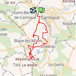
Randonnée Marche de 14,6 km à découvrir à Occitanie, Tarn, Blaye-les-Mines. Cette randonnée est proposée par jab31.

Description

Cap Découverte; autour de la Découverte: bois , terrils et faubourg

Profil altimétrique

Localisation

Pays :
France
Région :
Occitanie
Département/Province :
Tarn
Commune :
Blaye-les-Mines
Localité :
Unknown
Départ:(Dec)
Départ:(UTM)
431380 ; 4877801 (31T) N.

Randonnées à proximité

Randonnée A pied Monestiés - Circuit de la Borie Blanche - Photo
A pied
PRO

A pied

Facile
Monestiés, Occitanie, Tarn, France
6 km | 8,1 km-effort
1h 50min
Oui
Randonnée Marche Rosières - Rosières version courte - Photo
Marche
tercla

Marche

Facile
Rosières, Occitanie, Tarn, France
13,3 km | 17 km-effort
3h 0min
Oui
Randonnée Marche Labastide-Gabausse - Le sentier des pigeonniers Labastide Gabausse - Photo
Marche
tercla

Marche

Très facile
Labastide-Gabausse, Occitanie, Tarn, France
10,6 km | 14,4 km-effort
3h 26min
Oui
Randonnée A pied Sainte-Gemme - Lo_Camìn_del_Carboniers_chemin_des_paysans_mineurs_Sainte_Gemme - Photo
A pied
tercla

A pied

Facile
Sainte-Gemme, Occitanie, Tarn, France
10 km | 13,4 km-effort
3h 2min
Oui
Randonnée A pied Trévien - La Roucarié/ Monestiés - Photo
A pied
tercla

A pied

Moyen
Trévien, Occitanie, Tarn, France
17,9 km | 23 km-effort
5h 7min
Oui
Randonnée Marche Rosières - Boucle Rosières pont de Maux - Photo
Marche
tercla

Marche

Difficile
Rosières, Occitanie, Tarn, France
24 km | 30 km-effort
6h 0min
Oui
Randonnée Marche Taïx - cap decouverte - Photo
Marche
Bernard Larroque

Marche

Facile
Taïx, Occitanie, Tarn, France
29 km | 35 km-effort
3h 28min
Non
Randonnée Marche Le Garric - Le sentier de Pouzonac - Photo
Marche
tercla

Marche

Très facile
Le Garric, Occitanie, Tarn, France
10,3 km | 12,7 km-effort
2h 18min
Oui
Randonnée Marche Rosières - Rosières 22 KM - Photo
Marche
J-Mi

Marche

Moyen
Rosières, Occitanie, Tarn, France
24 km | 31 km-effort
Inconnu
Oui


Fermer
Mes abonnements