Randonnée Marche Tomblaine - Meurthe, Canal, Nancy, St Max - Photo

Meurthe, Canal, Nancy, St Max

 joelclaudel
joelclaudel

Utilisateur

© OpenStreetMap contributors
Longueur
Longueur
12,1 km
Altitude max
Altitude max
207 m
Dénivelé positif
Dénivelé positif
96 m
Km-Effort
Km-Effort  
13,4 km
Altitude min
Altitude min
187 m
Dénivelé négatif
Dénivelé négatif
99 m
Boucle
Boucle
Oui
Date de création :
2018-04-17 13:45:39.568
Dernière modification :
2018-04-17 13:45:39.568

(0 Avis)

Marche
Marche
3h07
Difficulté : Facile

Scannez ce code QR pour ouvrir la randonnée dans l'application SityTrail

Application GPS de randonnée GRATUITE

Logo SityTrail SityTrail

IGN / Instituts géographiques

Télécharger SityTrail sur l'App Store Télécharger SityTrail sur Google Play

Logo SityTrail SityTrail World

Le monde est à vous

Télécharger SityTrail sur l'App Store Télécharger SityTrail sur Google Play Télécharger SityTrail sur Huawei AppGallery

À propos

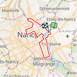
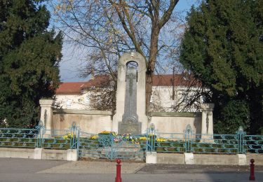
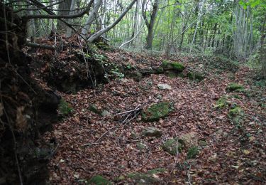
Randonnée Marche de 12,1 km à découvrir à Grand Est, Meurthe-et-Moselle, Tomblaine. Cette randonnée est proposée par joelclaudel.

Description

Parking stade Marcel Picot.
Beau parcours le long de la Meurthe, du canal, Faubourg St Georges,places Stanislas et Carrière, Pépinière.
A faire en toutes saisons.

Profil altimétrique

Localisation

Pays :
France
Région :
Grand Est
Département/Province :
Meurthe-et-Moselle
Commune :
Tomblaine
Localité :
Unknown
Départ:(Dec)
Départ:(UTM)
294635 ; 5397364 (32U) N.

Randonnées à proximité

Randonnée Course à pied Pulnoy - Parcours de santé PULNOY - Photo
Course à pied
DENOMME

Course à pied

Très facile
(1)
Pulnoy, Grand Est, Meurthe-et-Moselle, France
4,8 km | 6 km-effort
58min
Oui
Randonnée A pied Champigneulles - Circuit du Val Saint-Barthélémy - Photo
A pied
PRO

A pied

Facile
Champigneulles, Grand Est, Meurthe-et-Moselle, France
7 km | 8,6 km-effort
1h 57min
Oui
Randonnée A pied Agincourt - Circuit M - Photo
A pied
PRO

A pied

Facile
Agincourt, Grand Est, Meurthe-et-Moselle, France
13,3 km | 17,8 km-effort
4h 3min
Non
Randonnée Marche Vandœuvre-lès-Nancy - Randonnée USEP 2023 - Photo
Marche
nicolas54230

Marche

Difficile
(1)
Vandœuvre-lès-Nancy, Grand Est, Meurthe-et-Moselle, France
11,7 km | 15,2 km-effort
3h 27min
Non
Randonnée Marche Nancy - Ma rando du jour - Photo
Marche
Toyot 8

Marche

Difficile
Nancy, Grand Est, Meurthe-et-Moselle, France
35 km | 41 km-effort
5h 55min
Oui
Randonnée Marche Nancy - Nancy Gondreville Nancy - Photo
Marche
Toyot 8

Marche

Difficile
Nancy, Grand Est, Meurthe-et-Moselle, France
64 km | 74 km-effort
10h 57min
Oui
Randonnée Marche Nancy - Nancy Saizeray Jaillon Pierre la Treiche Marion Nancy  - Photo
Marche
Toyot 8

Marche

Difficile
Nancy, Grand Est, Meurthe-et-Moselle, France
73 km | 85 km-effort
12h 13min
Oui
Randonnée A pied Champigneulles - Circuit de Bellefontaine - général ouest - Photo
A pied
PRO

A pied

Facile
Champigneulles, Grand Est, Meurthe-et-Moselle, France
6,1 km | 8 km-effort
1h 48min
Non
Randonnée A pied Champigneulles - Circuit du Vallum de la Fourasse - Photo
A pied
PRO

A pied

Facile
Champigneulles, Grand Est, Meurthe-et-Moselle, France
3,3 km | 4,9 km-effort
1h 6min
Oui


Fermer
Mes abonnements