Randonnée V.T.T. Saint-Céré - Saint-Céré / Loubressac - Photo

Saint-Céré / Loubressac

 marmotte64
marmotte64

Utilisateur

© OpenStreetMap contributors
Longueur
Longueur
25 km
Altitude max
Altitude max
250 m
Dénivelé positif
Dénivelé positif
255 m
Km-Effort
Km-Effort  
28 km
Altitude min
Altitude min
127 m
Dénivelé négatif
Dénivelé négatif
256 m
Boucle
Boucle
Oui
Date de création :
2014-12-10 00:00:00.0
Dernière modification :
2014-12-10 00:00:00.0

(1 Avis)

V.T.T.
V.T.T.
--
Difficulté : Moyen

Scannez ce code QR pour ouvrir la randonnée dans l'application SityTrail

Application GPS de randonnée GRATUITE

Logo SityTrail SityTrail

IGN / Instituts géographiques

Télécharger SityTrail sur l'App Store Télécharger SityTrail sur Google Play

Logo SityTrail SityTrail World

Le monde est à vous

Télécharger SityTrail sur l'App Store Télécharger SityTrail sur Google Play Télécharger SityTrail sur Huawei AppGallery

À propos

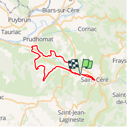
Randonnée V.T.T. de 25 km à découvrir à Occitanie, Lot, Saint-Céré. Cette randonnée est proposée par marmotte64.

Profil altimétrique

Photos

Points d'intérêt

Point d'intérêt Autoire - Notre Dame des Champs - Photo
marmotte64
Point d'intérêt Loubressac - Loubressac - Photo
marmotte64
LOUBRESSAC 
Point d'intérêt Loubressac - Castelnau - Photo
marmotte64
LOUBRESSAC 

Localisation

Pays :
France
Région :
Occitanie
Département/Province :
Lot
Commune :
Saint-Céré
Localité :
Unknown
Départ:(Dec)
Départ:(UTM)
410918 ; 4968392 (31T) N.

Commentaires

Veuillez vous connecter pour laisser un commentaire ou une note


Randonnées à proximité

Randonnée Marche Prudhomat - autour de castelnau - Photo
Marche
lefrancm

Marche

Très facile
(1)
Prudhomat, Occitanie, Lot, France
3,5 km | 4,8 km-effort
1h 48min
Non
Randonnée A pied Saint-Céré - Randonnées au Pays du Saint-Céré - Photo
A pied
PRO

A pied

Facile
Saint-Céré, Occitanie, Lot, France
13,3 km | 19,3 km-effort
4h 23min
Non
Randonnée A pied Saint-Jean-Lespinasse - St Jean Lespinasse - La Césarine - Photo
A pied
PRO

A pied

Facile
Saint-Jean-Lespinasse, Occitanie, Lot, France
3,8 km | 5,9 km-effort
1h 20min
Oui
Randonnée A pied Saint-Céré - St Céré - Les tours de St Laurent - Photo
A pied
PRO

A pied

Facile
Saint-Céré, Occitanie, Lot, France
4,9 km | 7,8 km-effort
1h 45min
Oui
Randonnée A pied Saint-Céré - St Céré - Le Causse de Lauriol - Photo
A pied
PRO

A pied

Facile
Saint-Céré, Occitanie, Lot, France
9,1 km | 12,3 km-effort
2h 47min
Oui
Randonnée A pied Saint-Céré - St Céré - De Pommiers à Tourel - Photo
A pied
PRO

A pied

Facile
Saint-Céré, Occitanie, Lot, France
7,8 km | 11 km-effort
2h 30min
Oui
Randonnée Marche Loubressac - autoire cascade siran - Photo
Marche
Forsans

Marche

Moyen
Loubressac, Occitanie, Lot, France
5,5 km | 8,4 km-effort
1h 55min
Non
Randonnée Marche Saint-Jean-Lespinasse - La Causse de Lauriol - Photo
Marche
richardsimopons

Marche

Saint-Jean-Lespinasse, Occitanie, Lot, France
10,6 km | 14,2 km-effort
3h 6min
Oui
Randonnée Marche Autoire - Autoire - Loubressac ( Boucle ) - Photo
Marche
neitag61

Marche

Moyen
Autoire, Occitanie, Lot, France
10,4 km | 15,1 km-effort
3h 9min
Oui


Fermer
Mes abonnements