Randonnée Marche Châtel-Saint-Germain - Balade des bateries - Photo
 Bitzlav
Bitzlav

Utilisateur

© OpenStreetMap contributors
Longueur
Longueur
8,2 km
Altitude max
Altitude max
351 m
Dénivelé positif
Dénivelé positif
184 m
Km-Effort
Km-Effort  
10,6 km
Altitude min
Altitude min
207 m
Dénivelé négatif
Dénivelé négatif
181 m
Boucle
Boucle
Oui
Date de création :
2014-12-10 00:00:00.0
Dernière modification :
2014-12-10 00:00:00.0

(0 Avis)

Marche
Marche
2h00
Difficulté : Moyen

Scannez ce code QR pour ouvrir la randonnée dans l'application SityTrail

Application GPS de randonnée GRATUITE

Logo SityTrail SityTrail

IGN / Instituts géographiques

Télécharger SityTrail sur l'App Store Télécharger SityTrail sur Google Play

Logo SityTrail SityTrail World

Le monde est à vous

Télécharger SityTrail sur l'App Store Télécharger SityTrail sur Google Play Télécharger SityTrail sur Huawei AppGallery

À propos

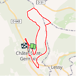
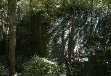
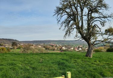
Randonnée Marche de 8,2 km à découvrir à Grand Est, Moselle, Châtel-Saint-Germain. Cette randonnée est proposée par Bitzlav.

Description

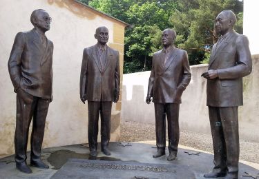
Petite balade pour découvrir un site en fin de parcourt.

Profil altimétrique

Localisation

Pays :
France
Région :
Grand Est
Département/Province :
Moselle
Commune :
Châtel-Saint-Germain
Localité :
Unknown
Départ:(Dec)
Départ:(UTM)
286994 ; 5445513 (32U) N.

Randonnées à proximité

Randonnée Marche Plappeville - Saint Quentin - Photo
Marche
edmondnagel

Marche

Moyen
(1)
Plappeville, Grand Est, Moselle, France
6,9 km | 9,2 km-effort
1h 59min
Oui
Randonnée Marche Châtel-Saint-Germain - Châtel-Saint-Germain - Photo
Marche
edmondnagel

Marche

Moyen
(1)
Châtel-Saint-Germain, Grand Est, Moselle, France
13,8 km | 17 km-effort
3h 39min
Oui
Randonnée Marche Plappeville - Autour du fort de Plappeville. - Photo
Marche
edmondnagel

Marche

Facile
(1)
Plappeville, Grand Est, Moselle, France
8,9 km | 11 km-effort
2h 55min
Oui
Randonnée A pied Vaux - Circuit de la Vallée de la Mance - Photo
A pied
PRO

A pied

Facile
Vaux, Grand Est, Moselle, France
12 km | 16 km-effort
3h 37min
Oui
Randonnée A pied Lessy - Circuit de Plappeville - Photo
A pied
PRO

A pied

Facile
Lessy, Grand Est, Moselle, France
8,5 km | 11,2 km-effort
2h 32min
Oui
Randonnée A pied Scy-Chazelles - Circuit Robert Schuman - Photo
A pied
PRO

A pied

Facile
Scy-Chazelles, Grand Est, Moselle, France
3,5 km | 5 km-effort
1h 7min
Non
Randonnée A pied Scy-Chazelles - Circuit du Tour du Mont St Quentin - Photo
A pied
PRO

A pied

Facile
Scy-Chazelles, Grand Est, Moselle, France
4,9 km | 6,7 km-effort
1h 31min
Non
Randonnée Marche Saulny - plesnois - Photo
Marche
pistou

Marche

Moyen
(2)
Saulny, Grand Est, Moselle, France
5,8 km | 7,9 km-effort
1h 24min
Oui
Randonnée Marche Saulny - Saulny 8 mai 2013 14 km - Photo
Marche
lbu

Marche

Très facile
(1)
Saulny, Grand Est, Moselle, France
14,8 km | 20 km-effort
3h 24min
Oui


Fermer
Mes abonnements