![](/images/other/stat-length.png)
![Randonnée Autre activité Heuqueville - heuqueville - Photo](https://media.geolcdn.com/t/1900/400/ext.pjpeg?maxdim=2&url=https%3A%2F%2Fstatic1.geolcdn.com%2Fsiteimages%2Fupload%2Ffiles%2F1545311037marcheuse_200dpi.jpg)
heuqueville
rendebnad
Utilisateur
![Longueur](/images/other/stat-length.png)
Longueur
12,3 km
![Altitude max](https://static1.geolcdn.com/siteimages/upload/files/1508320355ic_sort_altitude_max_24dp.png)
Altitude max
144 m
![Dénivelé positif](https://static1.geolcdn.com/siteimages/upload/files/1508320355ic_sort_den_pos_24dp.png)
Dénivelé positif
258 m
![Km-Effort](/images/other/stat-length.png)
Km-Effort
15,7 km
![Altitude min](https://static1.geolcdn.com/siteimages/upload/files/1508320355ic_sort_altitude_min_24dp.png)
Altitude min
49 m
![Dénivelé négatif](https://static1.geolcdn.com/siteimages/upload/files/1508320355ic_sort_den_neg_24dp.png)
Dénivelé négatif
259 m
![Boucle](https://static1.geolcdn.com/siteimages/upload/files/16400158638029165_repeat_loop_refresh_sync_direction_icon.png)
Boucle
Oui
Date de création :
2019-01-15 12:10:41.95
Dernière modification :
2019-01-15 12:10:41.95
![Autre activité](https://static1.geolcdn.com/sitytour/trail-icons/900.png)
4h00
Difficulté : Moyen
![Scannez ce code QR pour ouvrir la randonnée dans l'application SityTrail](https://capi.geolives.com/qq0zvz2zws4bq2lad0pu/sitytour/trails/995013/qr.png?size=200)
Application GPS de randonnée GRATUITE
À propos
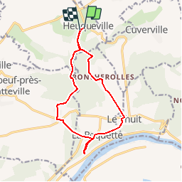
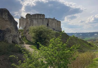
Randonnée Autre activité de 12,3 km à découvrir à Normandie, Eure, Heuqueville. Cette randonnée est proposée par rendebnad.
Description
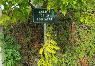
depart heuqueville,hameau de roncherolles, le Thuit,la Roquette, Fretteville,, Coix Chevalier bois de la couronne, heuqeville
Localisation
Pays :
France
Région :
Normandie
Département/Province :
Eure
Commune :
Heuqueville
Localité :
Unknown
Départ:(Dec)
Départ:(UTM)
379239 ; 5460602 (31U) N.
Commentaires
Randonnées à proximité
![Randonnée Marche Les Andelys - Les Andelys - Le Thuit et ND de Bellegarde - Photo](https://media.geolcdn.com/t/375/260/ext.jpg?maxdim=2&url=https%3A%2F%2Fstatic1.geolcdn.com%2Fsiteimages%2Fupload%2Ffiles%2F1553511878bg_sport_marche.png)
![Marche Marche](https://static1.geolcdn.com/sitytour/trail-icons/101.png)
Les Andelys - Le Thuit et ND de Bellegarde
Marche
Difficile
(1)
Les Andelys,
Normandie,
Eure,
France
![](/images/other/stat-length.png)
13,3 km | 16,2 km-effort
3h 40min
![](https://static1.geolcdn.com/siteimages/upload/files/16400158638029165_repeat_loop_refresh_sync_direction_icon.png)
Oui
![Randonnée Marche Les Andelys - Les Andelys - Le Thuit var 2 - Photo](https://media.geolcdn.com/t/375/260/ext.jpg?maxdim=2&url=https%3A%2F%2Fstatic1.geolcdn.com%2Fsiteimages%2Fupload%2Ffiles%2F1553511878bg_sport_marche.png)
![Marche Marche](https://static1.geolcdn.com/sitytour/trail-icons/101.png)
Les Andelys - Le Thuit var 2
Marche
Facile
(1)
Les Andelys,
Normandie,
Eure,
France
![](/images/other/stat-length.png)
8,3 km | 10,3 km-effort
2h 14min
![](https://static1.geolcdn.com/siteimages/upload/files/16400158638029165_repeat_loop_refresh_sync_direction_icon.png)
Oui
![Randonnée Marche Pont-Saint-Pierre - 20231024-Pont-St-Pierre - Photo](https://media.geolcdn.com/t/375/260/ext.jpg?maxdim=2&url=https%3A%2F%2Fmedia.geolcdn.com%2Ff%2F4052145c-1b1a-45b5-895f-0a73a0830d98.JPG)
![Marche Marche](https://static1.geolcdn.com/sitytour/trail-icons/101.png)
20231024-Pont-St-Pierre
Marche
Difficile
Pont-Saint-Pierre,
Normandie,
Eure,
France
![](/images/other/stat-length.png)
10,1 km | 13,3 km-effort
3h 20min
![](https://static1.geolcdn.com/siteimages/upload/files/16400158638029165_repeat_loop_refresh_sync_direction_icon.png)
Non
![Randonnée Marche Heuqueville - 20230810-Heuqueville Jourrnée - Photo](https://media.geolcdn.com/t/375/260/ext.jpg?maxdim=2&url=https%3A%2F%2Fmedia.geolcdn.com%2Ff%2Fabf9f114-cedb-4b67-a0c7-6866c6477a1a.JPG)
![Marche Marche](https://static1.geolcdn.com/sitytour/trail-icons/101.png)
20230810-Heuqueville Jourrnée
Marche
Difficile
Heuqueville,
Normandie,
Eure,
France
![](/images/other/stat-length.png)
20 km | 27 km-effort
5h 57min
![](https://static1.geolcdn.com/siteimages/upload/files/16400158638029165_repeat_loop_refresh_sync_direction_icon.png)
Oui
![Randonnée Marche Daubeuf-près-Vatteville - 20240528-daubeuf pres vatteville - Photo](https://media.geolcdn.com/t/375/260/ext.jpg?maxdim=2&url=https%3A%2F%2Fmedia.geolcdn.com%2Ff%2Fadf15bba-069b-459e-ad33-06394c5e8d1f.jpg)
![Marche Marche](https://static1.geolcdn.com/sitytour/trail-icons/101.png)
20240528-daubeuf pres vatteville
Marche
Moyen
Daubeuf-près-Vatteville,
Normandie,
Eure,
France
![](/images/other/stat-length.png)
11 km | 13,7 km-effort
3h 22min
![](https://static1.geolcdn.com/siteimages/upload/files/16400158638029165_repeat_loop_refresh_sync_direction_icon.png)
Oui
![Randonnée Marche Les Andelys - Les Andelys le Mont Pivin - Photo](https://media.geolcdn.com/t/375/260/ext.jpg?maxdim=2&url=https%3A%2F%2Fmedia.geolcdn.com%2Ff%2F2e30a977-82f2-4086-8b81-28620c9148e1.jpg)
![Marche Marche](https://static1.geolcdn.com/sitytour/trail-icons/101.png)
Les Andelys le Mont Pivin
Marche
Difficile
Les Andelys,
Normandie,
Eure,
France
![](/images/other/stat-length.png)
10,1 km | 14,4 km-effort
3h 16min
![](https://static1.geolcdn.com/siteimages/upload/files/16400158638029165_repeat_loop_refresh_sync_direction_icon.png)
Oui
![Randonnée Marche Le Thuit - 230602 Andelys A - Photo](https://media.geolcdn.com/t/375/260/ext.jpg?maxdim=2&url=https%3A%2F%2Fmedia.geolcdn.com%2Ff%2F13adf67b-3ef8-43a4-aa0b-ee1daaccfb66.jpg)
![Marche Marche](https://static1.geolcdn.com/sitytour/trail-icons/101.png)
![Randonnée Marche Les Andelys - Les falaises de craies des Andelys - Photo](https://media.geolcdn.com/t/375/260/ext.jpg?maxdim=2&url=https%3A%2F%2Fmedia.geolcdn.com%2Ff%2F72f276d6-7736-49b8-9562-6a2084f395e8.jpg)
![Marche Marche](https://static1.geolcdn.com/sitytour/trail-icons/101.png)
Les falaises de craies des Andelys
Marche
Difficile
Les Andelys,
Normandie,
Eure,
France
![](/images/other/stat-length.png)
7,6 km | 11,3 km-effort
3h 21min
![](https://static1.geolcdn.com/siteimages/upload/files/16400158638029165_repeat_loop_refresh_sync_direction_icon.png)
Oui
![Randonnée Marche Les Andelys - les Andelys du 11/09/2022 - Photo](https://media.geolcdn.com/t/375/260/ext.jpg?maxdim=2&url=https%3A%2F%2Fmedia.geolcdn.com%2Ff%2F495db3c6-ba78-44de-95e7-48ab65377867.jpg)
![Marche Marche](https://static1.geolcdn.com/sitytour/trail-icons/101.png)
les Andelys du 11/09/2022
Marche
Très difficile
Les Andelys,
Normandie,
Eure,
France
![](/images/other/stat-length.png)
18,1 km | 22 km-effort
4h 17min
![](https://static1.geolcdn.com/siteimages/upload/files/16400158638029165_repeat_loop_refresh_sync_direction_icon.png)
Oui