Joel26400

Offline

Randonnées

Randonnée Marche Laval-d'Aix - le dôme lavale d'Aix émane caux - Photo
Marche
Joel26400

Marche

Difficile
Laval-d'Aix, Auvergne-Rhône-Alpes, Drôme, France
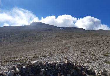
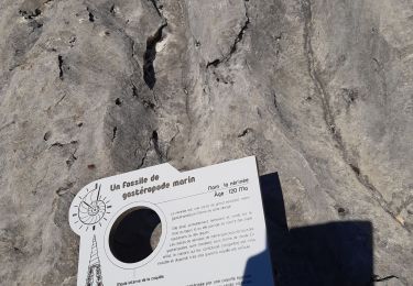
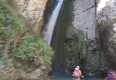
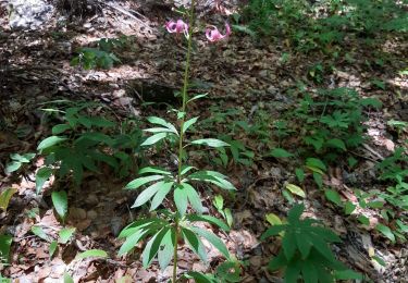
19,1 km | 41 km-effort
8h 55min
Oui
Randonnée Marche Val-Maravel - le pilhon la blanche.mont chauvet  - Photo
Marche
Joel26400

Marche

Moyen
Val-Maravel, Auvergne-Rhône-Alpes, Drôme, France
14,5 km | 27 km-effort
7h 6min
Oui
Randonnée Marche Châtillon-en-Diois - le pas des ampes de la plagne montagnette  - Photo
Marche
Joel26400

Marche

Difficile
Châtillon-en-Diois, Auvergne-Rhône-Alpes, Drôme, France
16,7 km | 29 km-effort
7h 56min
Oui
Randonnée Marche Plan-de-Baix - canyon des gueulards  - Photo
Marche
Joel26400

Marche

Très facile
Plan-de-Baix, Auvergne-Rhône-Alpes, Drôme, France
10,7 km | 16,3 km-effort
5h 5min
Oui
Randonnée Marche Valdrôme - la batie des fonds. banne carabesse  - Photo
Marche
Joel26400

Marche

Difficile
Valdrôme, Auvergne-Rhône-Alpes, Drôme, France
21 km | 34 km-effort
8h 53min
Oui
Randonnée Marche Chichilianne - la richardiere rocher du parquet - Photo
Marche
Joel26400

Marche

Très facile
Chichilianne, Auvergne-Rhône-Alpes, Isère, France
16,7 km | 30 km-effort
8h 19min
Oui
Randonnée Marche Die - le dôme par abbaye de valcroissant  - Photo
Marche
Joel26400

Marche

Difficile
Die, Auvergne-Rhône-Alpes, Drôme, France
15,4 km | 34 km-effort
7h 54min
Oui
Randonnée Marche Montmaur - pic de bure  - Photo
Marche
Joel26400

Marche

Difficile
Montmaur, Provence-Alpes-Côte d'Azur, Hautes-Alpes, France
17,4 km | 0 m-effort
8h 4min
Oui
Randonnée Marche Rencurel - la goulandiere balme de rancurel - Photo
Marche
Joel26400

Marche

Moyen
Rencurel, Auvergne-Rhône-Alpes, Isère, France
20 km | 33 km-effort
8h 12min
Oui
Randonnée Marche Omblèze - les 3 perles de la servante. - Photo
Marche
Joel26400

Marche

Moyen
Omblèze, Auvergne-Rhône-Alpes, Drôme, France
23 km | 35 km-effort
8h 35min
Oui
Randonnée Marche Romeyer - romeyer pison econdu  - Photo
Marche
Joel26400

Marche

Moyen
Romeyer, Auvergne-Rhône-Alpes, Drôme, France
19,3 km | 31 km-effort
7h 11min
Oui
Randonnée Marche Romeyer - guai des sableurs col du menil - Photo
Marche
Joel26400

Marche

Moyen
Romeyer, Auvergne-Rhône-Alpes, Drôme, France
16,2 km | 30 km-effort
7h 36min
Oui
Randonnée Marche Châtillon-en-Diois - menée le natal le jocou  - Photo
Marche
Joel26400

Marche

Difficile
Châtillon-en-Diois, Auvergne-Rhône-Alpes, Drôme, France
17,3 km | 34 km-effort
8h 56min
Oui
Randonnée Marche Saou - saou bergerie patuel auberge muletiers  - Photo
Marche
Joel26400

Marche

Très facile
Saou, Auvergne-Rhône-Alpes, Drôme, France
12,5 km | 17,4 km-effort
5h 19min
Oui
Randonnée Marche Saou - grand et petit pomerole  - Photo
Marche
Joel26400

Marche

Facile
Saou, Auvergne-Rhône-Alpes, Drôme, France
13,7 km | 24 km-effort
5h 1min
Oui
Randonnée Marche Charens - charens tarsimoure  - Photo
Marche
Joel26400

Marche

Difficile
Charens, Auvergne-Rhône-Alpes, Drôme, France
17,1 km | 29 km-effort
7h 43min
Oui
Randonnée Marche Romeyer - romeyer.plautret.econdu. - Photo
Marche
Joel26400

Marche

Très difficile
Romeyer, Auvergne-Rhône-Alpes, Drôme, France
23 km | 39 km-effort
8h 23min
Oui
Randonnée Marche Saint-Julien-en-Quint - st Julien en quint but st genis  - Photo
Marche
Joel26400

Marche

Difficile
Saint-Julien-en-Quint, Auvergne-Rhône-Alpes, Drôme, France
20 km | 34 km-effort
8h 9min
Oui
Randonnée Marche Chastel-Arnaud - pas de la motte les 3becs - Photo
Marche
Joel26400

Marche

Très difficile
Chastel-Arnaud, Auvergne-Rhône-Alpes, Drôme, France
17,3 km | 34 km-effort
7h 58min
Oui
Randonnée Marche Gigondas - dentelles le truc  - Photo
Marche
Joel26400

Marche

Moyen
Gigondas, Provence-Alpes-Côte d'Azur, Vaucluse, France
12,7 km | 21 km-effort
5h 1min
Oui
Randonnée Marche Gigondas - les crêtes de st armand - Photo
Marche
Joel26400

Marche

Moyen
Gigondas, Provence-Alpes-Côte d'Azur, Vaucluse, France
17 km | 27 km-effort
6h 36min
Oui

Fermer
Mes abonnements