Trail Walking Limours - Essonne_Limours=>Chardonnet=>Forges - Photo

Essonne_Limours=>Chardonnet=>Forges

© OpenStreetMap contributors
Length
Length
10.1 km
Max alt
Max alt
177 m
Uphill gradient
Uphill gradient
163 m
Km-Effort
Km-Effort  
12.3 km
Min alt
Min alt
112 m
Downhill gradient
Downhill gradient
167 m
Boucle
Boucle
Yes
Creation date :
2019-05-09 05:08:19.864
Updated on :
2022-11-13 07:46:43.489

(0 Reviews)

Walking
Walking
2h39
Difficulty : Easy

Scan this QR Code to open this trail in the SityTrail application

FREE GPS app for hiking

Logo SityTrail SityTrail

IGN / Geographical institutes

Download SityTrail from the App Store Download SityTrail from Google Play

Logo SityTrail SityTrail World

The world is yours!

Download SityTrail from the App Store Download SityTrail from Google Play Download SityTrail on Huawei AppGallery

About

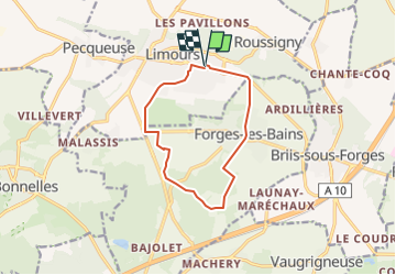
Trail Walking of 10.1 km to be discovered at Ile-de-France, Essonne, Limours. This trail is proposed by BMorin91470.

Description

Au départ du parking de La Scène à Limours, remonter vers le Couvent par la rue du Saut-du-Loup (arboretum) et suivre à gauche le chemin qui longe le golf jusqu'à Forges-Les-Bains (hameau du Parc); prendre le chemin vers Chardonnet et traverser la hameau. revenir vers Forges par la Route Neuve et traverser le bourg puis le bois des Touanes. Redescendre à Pivot et retour à La Scène

Elevation profile

Positioning

Country:
France
Region :
Ile-de-France
Department/Province :
Essonne
Municipality :
Limours
Location:
Unknown
Start:(UTM)
432667 ; 5388180 (31U) N.

Trails nearby

Trail Walking Bonnelles - _Le rallye de Bonnelles à Rochefort - Photo
Walking
GUIDE+

Walking

Medium
(10)
Bonnelles, Ile-de-France, Yvelines, France
14.1 km | 16.4 km-effort
3h 30min
Yes
Trail Walking Choisel - _Si Choisel m'était conté - Photo
Walking
GUIDE+

Walking

Easy
(8)
Choisel, Ile-de-France, Yvelines, France
5.6 km | 6.6 km-effort
1h 27min
Yes
Trail Walking Limours - Essonne_Tour_des_Fermes_de_la_Prédecelle - Photo
Walking
BMorin91470

Walking

Very easy
(1)
Limours, Ile-de-France, Essonne, France
12.9 km | 14.3 km-effort
3h 43min
Yes
Trail Walking Gometz-le-Châtel - Autour de Gometz le Châtel - Photo
Walking
tracegps

Walking

Medium
(1)
Gometz-le-Châtel, Ile-de-France, Essonne, France
7.8 km | 10.6 km-effort
2h 30min
Yes
Trail Walking Limours - Essonne_RD_Limours=>Viaduc=>Prédecelle=>Chaumusson - Photo
Walking
BMorin91470

Walking

Easy
(1)
Limours, Ile-de-France, Essonne, France
7.4 km | 8.4 km-effort
2h 30min
Yes
Trail Walking Limours - 20210319_Limours_Viaduc_Prédecelle_Amont - Photo
Walking
BMorin91470

Walking

Easy
(1)
Limours, Ile-de-France, Essonne, France
8.7 km | 9.9 km-effort
2h 30min
Yes
Trail Walking Pecqueuse - 20191019_Tour_des_Fermes_réalisé - Photo
Walking
BMorin91470

Walking

Very easy
(1)
Pecqueuse, Ile-de-France, Essonne, France
13.8 km | 15.2 km-effort
3h 43min
Yes
Trail Mountain bike Choisel - Rallye VTT de Choisel - Photo
Mountain bike
tracegps

Mountain bike

Very difficult
(1)
Choisel, Ile-de-France, Yvelines, France
60 km | 75 km-effort
4h 0min
Yes
Trail Walking Gometz-le-Châtel - Gometz-le-Chatel.11022024 - Photo
Walking
aucamus

Walking

Medium
(1)
Gometz-le-Châtel, Ile-de-France, Essonne, France
17.9 km | 24 km-effort
5h 28min
Yes


Close
My subscriptions