Trail Walking Treize-Vents - Mallièvre Circuit des côteaux - Photo

Mallièvre Circuit des côteaux

© OpenStreetMap contributors
Length
Length
14.4 km
Max alt
Max alt
191 m
Uphill gradient
Uphill gradient
275 m
Km-Effort
Km-Effort  
18.1 km
Min alt
Min alt
120 m
Downhill gradient
Downhill gradient
275 m
Boucle
Boucle
Yes
Creation date :
2018-04-17 21:41:42.053
Updated on :
2018-04-17 21:41:42.053

(0 Reviews)

Walking
Walking
3h50
Difficulty : Medium

Scan this QR Code to open this trail in the SityTrail application

FREE GPS app for hiking

Logo SityTrail SityTrail

IGN / Geographical institutes

Download SityTrail from the App Store Download SityTrail from Google Play

Logo SityTrail SityTrail World

The world is yours!

Download SityTrail from the App Store Download SityTrail from Google Play Download SityTrail on Huawei AppGallery

About

Trail Walking of 14.4 km to be discovered at Pays de la Loire, Vendée, Treize-Vents. This trail is proposed by neoroll44.

Description

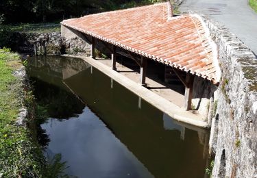
A travers le sentier des coquelicots, empruntez les anciens chemins creux (restés dans leur état primitif) d'accès et de servitudes des moulins de bord de Sèvre Nantaise.
De la Boulaie, aller vers Mallièvre et la Sèvre.
1. Suivre la Sèvre sur 1km.
2. Prendre à droite pour rallier la Chataigneraie.
3. Prendre à gauche et suivre le chemin de terre et la route goudronnée en passant par Chambon et la Martinière.
4. Prendre à gauche en direction du Coteau et du moulin de Charbonneau, faites la petite boucle et ensuite revenez sur vos pas et au point de départ en traversant le bourg de Treize-Vents.

Elevation profile

Points of interest

Point of interest Treize-Vents -  - Photo
neoroll44
TREIZE-VENTS 
Point of interest Treize-Vents -  - Photo
neoroll44
TREIZE-VENTS 
Point of interest Treize-Vents -  - Photo
neoroll44
TREIZE-VENTS 
Point of interest Mauléon -  - Photo
neoroll44
MAULÉON 

Positioning

Country:
France
Region :
Pays de la Loire
Department/Province :
Vendée
Municipality :
Treize-Vents
Location:
Unknown
Start:(UTM)
663509 ; 5198003 (30T) N.

Trails nearby

Trail Walking Saint-Laurent-sur-Sèvre - Rando St Laurent sur Sèvres 15km - Photo
Walking
GUIDE
jeanmarcMasson

Walking

Very difficult
Saint-Laurent-sur-Sèvre, Pays de la Loire, Vendée, France
15.4 km | 19.1 km-effort
4h 14min
Yes
Trail Walking Saint-Laurent-sur-Sèvre - ViaducBarbin - Photo
Walking
patrando49

Walking

Easy
(2)
Saint-Laurent-sur-Sèvre, Pays de la Loire, Vendée, France
8.4 km | 10.4 km-effort
2h 17min
Yes
Trail Walking Treize-Vents - rando les treize cents 18km - Photo
Walking
GUIDE
jeanmarcMasson

Walking

Very difficult
Treize-Vents, Pays de la Loire, Vendée, France
19.6 km | 24 km-effort
4h 47min
No
Trail Walking Treize-Vents - treize vents Mallievre - Photo
Walking
marianne guichoux

Walking

Very difficult
Treize-Vents, Pays de la Loire, Vendée, France
18.1 km | 23 km-effort
4h 51min
No
Trail Walking Saint-Laurent-sur-Sèvre - saint laurent sur sevre - Photo
Walking
marianne guichoux

Walking

Difficult
Saint-Laurent-sur-Sèvre, Pays de la Loire, Vendée, France
14 km | 17.4 km-effort
3h 52min
No
Trail Quad Mauléon - Quadman85  - Photo
Quad
Quadman85

Quad

Mauléon, New Aquitaine, Deux-Sèvres, France
56 km | 67 km-effort
2h 46min
Yes
Trail Quad Mauléon - Quad christian  - Photo
Quad
Quadman85

Quad

Mauléon, New Aquitaine, Deux-Sèvres, France
31 km | 37 km-effort
1h 6min
No
Trail Walking Treize-Vents - Treize vents Mallièvre,18km - Photo
Walking
marianne guichoux

Walking

Very difficult
Treize-Vents, Pays de la Loire, Vendée, France
17.9 km | 22 km-effort
5h 3min
Yes
Trail Walking Saint-Laurent-sur-Sèvre - Saint Laurent sur Sèvre  viaduc de Barbin Le Guy 15km - Photo
Walking
marianne guichoux

Walking

Difficult
Saint-Laurent-sur-Sèvre, Pays de la Loire, Vendée, France
14.8 km | 18.2 km-effort
4h 8min
Yes


Close
My subscriptions