Randonnée Marche Planès - tour autour de Planés  - Photo
 ThonyM
ThonyM

Utilisateur

© OpenStreetMap contributors
Longueur
Longueur
16,2 km
Altitude max
Altitude max
1664 m
Dénivelé positif
Dénivelé positif
666 m
Km-Effort
Km-Effort  
25 km
Altitude min
Altitude min
1316 m
Dénivelé négatif
Dénivelé négatif
664 m
Boucle
Boucle
Oui
Date de création :
2018-04-17 10:52:58.85
Dernière modification :
2018-04-17 10:52:58.85

(0 Avis)

Marche
Marche
5h00
Difficulté : Moyen

Scannez ce code QR pour ouvrir la randonnée dans l'application SityTrail

Application GPS de randonnée GRATUITE

Logo SityTrail SityTrail

IGN / Instituts géographiques

Télécharger SityTrail sur l'App Store Télécharger SityTrail sur Google Play

Logo SityTrail SityTrail World

Le monde est à vous

Télécharger SityTrail sur l'App Store Télécharger SityTrail sur Google Play Télécharger SityTrail sur Huawei AppGallery

À propos

Randonnée Marche de 16,2 km à découvrir à Occitanie, Pyrénées-Orientales, Planès. Cette randonnée est proposée par ThonyM.

Description

En passant par Mont-Louis

Profil altimétrique

Photos

Points d'intérêt

Point d'intérêt Saint-Pierre-dels-Forcats - source ferrugineuse - Photo
ThonyM
SAINT-PIERRE-DELS-FORCATS 

Localisation

Pays :
France
Région :
Occitanie
Département/Province :
Pyrénées-Orientales
Commune :
Planès
Localité :
Unknown
Départ:(Dec)
Départ:(UTM)
429257 ; 4704789 (31T) N.

Randonnées à proximité

Randonnée Marche Eyne - Eyne,col de Nuria,pic d'Eyne,Torre d'Eyne,Eyne. - Photo
Marche
Machaon6

Marche

Très difficile
(1)
Eyne, Occitanie, Pyrénées-Orientales, France
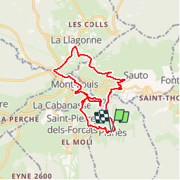
24 km | 43 km-effort
8h 44min
Oui
Randonnée Marche Fontpédrouse - Tour du Cucurucull - Photo
Marche
Pek56

Marche

Moyen
(1)
Fontpédrouse, Occitanie, Pyrénées-Orientales, France
9,3 km | 18,5 km-effort
3h 24min
Oui
Randonnée Marche Planès - étang de Planès - Photo
Marche
fhascoet

Marche

Moyen
(2)
Planès, Occitanie, Pyrénées-Orientales, France
10,8 km | 19,6 km-effort
3h 54min
Non
Randonnée Marche Fontpédrouse - fontpérouse sentier des canaux et sources chaudes naturelles_T - Photo
Marche
force

Marche

Moyen
(1)
Fontpédrouse, Occitanie, Pyrénées-Orientales, France
13,7 km | 25 km-effort
5h 9min
Oui
Randonnée Marche Eyne - Le Cambre d'Ase - Photo
Marche
tracegps

Marche

Difficile
(1)
Eyne, Occitanie, Pyrénées-Orientales, France
8,9 km | 22 km-effort
4h 0min
Oui
Randonnée Marche Eyne - Vallée d'Eyne - Photo
Marche
GUIDE
nadinebondoux

Marche

Moyen
Eyne, Occitanie, Pyrénées-Orientales, France
10,7 km | 17,6 km-effort
4h 40min
Oui
Randonnée Marche Saint-Pierre-dels-Forcats - bains  de St Thomas  - Photo
Marche
Ptitjack30

Marche

Moyen
(1)
Saint-Pierre-dels-Forcats, Occitanie, Pyrénées-Orientales, France
8,6 km | 12,2 km-effort
2h 42min
Non
Randonnée Marche La Llagonne - llagonne - Calvet - Photo
Marche
merencianoep

Marche

Moyen
(2)
La Llagonne, Occitanie, Pyrénées-Orientales, France
11,2 km | 14,2 km-effort
3h 0min
Non
Randonnée Marche Eyne - eyne - Photo
Marche
gardelg

Marche

Moyen
(2)
Eyne, Occitanie, Pyrénées-Orientales, France
6,2 km | 8,2 km-effort
2h 1min
Oui


Fermer
Mes abonnements