Home
World
NEW
Premium
Winkel
tochten
Artikels
Help - ondersteuning
Français
English
Nederlands
Español
Italiano
Deutsch
Aansluiting
Home
World
Premium
Winkel
tochten
Artikels
Help - ondersteuning
SityTrail
>
POI's
>
GC13VVE
SityTrail
>
POI's
>
GC13VVE
GC13VVE
Beschrijving
le coup de sabre by Jean CLOU,
Foto's
Ontdek GC13VVE met de volgende tochten...
tracegps
Dent du Villard depuis La Rosière
Stappen
Moeilijk
(1)
Courchevel, Auvergne-Rhône-Alpes, Savoie, France
9,4 km | 19,2 km-effort
6h 0min
Ja
tracegps
Gebruiker
©
OpenStreetMap
contributors
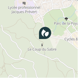
Plaatsbepaling
Land:
France
Regio :
Auvergne-Rhône-Alpes
Departement/Provincie :
Isère
Gemeente :
Fontaine
Locatie:
Unknown
Plaatsbepaling
45.192617 / 5.667417
Datum van aanmaak :
2018-04-09 12:16:47.553
Laatste wijziging
2018-04-09 12:16:47.553
(0 Bericht)
Opmerkingen
Gelieve in te loggen om een commentaar of een beoordeling achter te laten
POI's in de buurt
tracegps
GC13VVE
FONTAINE
tracegps
GC13VVE
FONTAINE
tracegps
GC13VVE
FONTAINE
tracegps
GC13VVE
FONTAINE
tracegps
GC13VVE
FONTAINE
tracegps
GC13VVE
FONTAINE
tracegps
GC13VVE
FONTAINE
tracegps
GC13VVE
FONTAINE
Sluiten
Mijn abonnementen