Home
World
NEW
Premium
Winkel
tochten
Artikels
Help - ondersteuning
Français
English
Nederlands
Español
Italiano
Deutsch
Aansluiting
Home
World
Premium
Winkel
tochten
Artikels
Help - ondersteuning
SityTrail
>
POI's
>
GC16QAX
SityTrail
>
POI's
>
GC16QAX
GC16QAX
Beschrijving
La grotte des échelles by vilc
Foto's
Ontdek GC16QAX met de volgende tochten...
tracegps
Dent du Villard depuis La Rosière
Stappen
Moeilijk
(1)
Courchevel, Auvergne-Rhône-Alpes, Savoie, France
9,4 km | 19,2 km-effort
6h 0min
Ja
tracegps
Gebruiker
©
OpenStreetMap
contributors
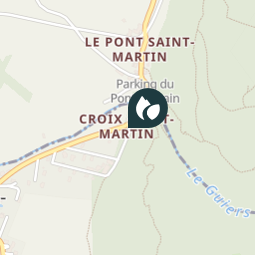
Plaatsbepaling
Land:
France
Regio :
Auvergne-Rhône-Alpes
Departement/Provincie :
Isère
Gemeente :
Saint-Christophe-sur-Guiers
Locatie:
Unknown
Plaatsbepaling
45.441433 / 5.78185
Datum van aanmaak :
2018-04-09 12:17:35.017
Laatste wijziging
2018-04-09 12:17:35.017
(0 Bericht)
Opmerkingen
Gelieve in te loggen om een commentaar of een beoordeling achter te laten
POI's in de buurt
tracegps
GC16QAX
SAINT-CHRISTOPHE-SUR-GUIERS
tracegps
GC16QAX
SAINT-CHRISTOPHE-SUR-GUIERS
tracegps
GC16QAX
SAINT-CHRISTOPHE-SUR-GUIERS
tracegps
GC16QAX
SAINT-CHRISTOPHE-SUR-GUIERS
tracegps
GC16QAX
SAINT-CHRISTOPHE-SUR-GUIERS
tracegps
GC16QAX
SAINT-CHRISTOPHE-SUR-GUIERS
tracegps
GC16QAX
SAINT-CHRISTOPHE-SUR-GUIERS
tracegps
GC16QAX
SAINT-CHRISTOPHE-SUR-GUIERS
Sluiten
Mijn abonnementen