Home
World
NEW
Premium
Winkel
tochten
Artikels
Help - ondersteuning
Français
English
Nederlands
Español
Italiano
Deutsch
Aansluiting
Home
World
Premium
Winkel
tochten
Artikels
Help - ondersteuning
SityTrail
>
POI's
>
GC12CY4
SityTrail
>
POI's
>
GC12CY4
GC12CY4
Beschrijving
Face au Mont Blanc by emil300,
Foto's
Ontdek GC12CY4 met de volgende tochten...
tracegps
Mont-Jovet depuis La Cour
Stappen
Moeilijk
(1)
Bozel, Auvergne-Rhône-Alpes, Savoie, France
13,5 km | 27 km-effort
6h 0min
Ja
tracegps
Gebruiker
©
OpenStreetMap
contributors
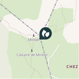
Plaatsbepaling
Land:
France
Regio :
Auvergne-Rhône-Alpes
Departement/Provincie :
Haute-Savoie
Gemeente :
Villard
Locatie:
Unknown
Plaatsbepaling
46.211417 / 6.475133
Datum van aanmaak :
2018-04-09 12:16:28.382
Laatste wijziging
2018-04-09 12:16:28.382
(0 Bericht)
Opmerkingen
Gelieve in te loggen om een commentaar of een beoordeling achter te laten
POI's in de buurt
tracegps
GC12CY4
VILLARD
tracegps
GC12CY4
VILLARD
tracegps
GC12CY4
VILLARD
tracegps
GC12CY4
VILLARD
tracegps
GC12CY4
VILLARD
tracegps
GC12CY4
VILLARD
tracegps
GC12CY4
VILLARD
tracegps
GC12CY4
VILLARD
Sluiten
Mijn abonnementen