Tocht Lopen Saiguède - Raide de Saiguède - Photo
 tracegps
tracegps

Gebruiker

© OpenStreetMap contributors
Lengte
Lengte
19 km
Max. hoogte
Max. hoogte
322 m
Positief hoogteverschil
279 m
Km-Effort
Km-Effort  
23 km
Min. hoogte
Min. hoogte
228 m
Negatief hoogteverschil
279 m
Boucle
Boucle
Ja
Datum van aanmaak :
2014-12-10 00:00:00.0
Laatste wijziging :
2014-12-10 00:00:00.0

(0 Bericht)

Lopen
Lopen
2h00
Moeilijkheid : Zeer moeilijk

Scan deze QR-code om de tocht te openen in de SityTrail-applicatie

Gratisgps-wandelapplicatie

Logo SityTrail SityTrail

IGN / Geografische instituten

SityTrail uit de App Store downloaden SityTrail uit Google Play downloaden

Logo SityTrail SityTrail World

De wereld gaat voor u open

SityTrail uit de App Store downloaden SityTrail uit Google Play downloaden SityTrail op Huawei AppGallery downloaden

Over ons

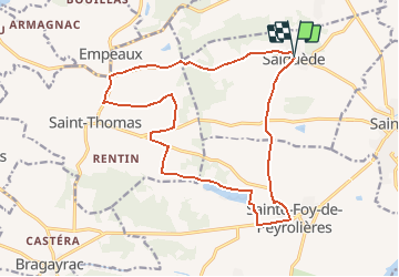
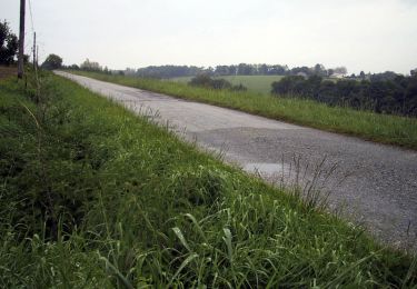
Tocht Lopen van 19 km beschikbaar op Occitanië, Haute-Garonne, Saiguède. Deze tocht wordt voorgesteld door tracegps.

Beschrijving

Saiguède, en Saves, est située sur la ligne de crête de partage des eaux entre la Save et la Garonne, à 25 km à l'ouest de Toulouse. Dès le départ, on grimpe .... pendant 4 km sur 100 m de dénivelé. Après 7,5 km, à Larroudé, joli chemin de 1 km. Puis, à 14 km, on longe le Lac de Minjoulet, dans les faubourgs de Ste Foy de Peyrolières, avant de revenir en montée et en descente sur Saiguède.

Hoogteprofiel

Foto's

Plaatsbepaling

Land:
France
Regio :
Occitanië
Departement/Provincie :
Haute-Garonne
Gemeente :
Saiguède
Locatie:
Unknown
Vertrek:(Dec)
Vertrek:(UTM)
350086 ; 4821237 (31T) N.

Wandeltochten in de omgeving

Tocht Stappen Saiguède - Raide de Saiguède - Photo
Stappen
tracegps

Stappen

Moeilijk
(1)
Saiguède, Occitanië, Haute-Garonne, France
19 km | 23 km-effort
4h 0min
Ja
Tocht Stappen Sainte-Foy-de-Peyrolières - RANDO-Ste Foy Téléthon 2012 - Photo
Stappen
Polo-31

Stappen

Gemakkelijk
Sainte-Foy-de-Peyrolières, Occitanië, Haute-Garonne, France
8 km | 9,3 km-effort
2h 2min
Ja
Tocht Stappen Sainte-Foy-de-Peyrolières - Lac et bois autour de Sainte Foy de Peyrolières - Photo
Stappen
tracegps

Stappen

Gemakkelijk
Sainte-Foy-de-Peyrolières, Occitanië, Haute-Garonne, France
9 km | 11,2 km-effort
2h 30min
Ja
Tocht Stappen Sainte-Foy-de-Peyrolières - Ste Foy de Peyrolières 13 Avril 2020 - Photo
Stappen
daniel3157

Stappen

Gemakkelijk
Sainte-Foy-de-Peyrolières, Occitanië, Haute-Garonne, France
16,4 km | 21 km-effort
4h 58min
Ja
Tocht Lopen Fontenilles - Fontenilles à Lias - Photo
Lopen
tracegps

Lopen

Moeilijk
Fontenilles, Occitanië, Haute-Garonne, France
13,7 km | 16,4 km-effort
1h 19min
Ja
Tocht Mountainbike Fontenilles - Fontenilles à Lias - Photo
Mountainbike
tracegps

Mountainbike

Medium
Fontenilles, Occitanië, Haute-Garonne, France
13,7 km | 16,4 km-effort
1h 0min
Ja
Tocht Lopen Fontenilles - De Fontenilles à Saiguède - Photo
Lopen
tracegps

Lopen

Moeilijk
Fontenilles, Occitanië, Haute-Garonne, France
16,2 km | 19,5 km-effort
1h 30min
Ja
Tocht Stappen Sainte-Foy-de-Peyrolières - Randonnée Sainte Foy de Peyrolières  - Photo
Stappen
Fafou64

Stappen

Sainte-Foy-de-Peyrolières, Occitanië, Haute-Garonne, France
10,7 km | 12,9 km-effort
2h 39min
Ja
Tocht Stappen Saiguède - Saiguède belles vues - Photo
Stappen
pidjam

Stappen

Heel gemakkelijk
Saiguède, Occitanië, Haute-Garonne, France
8,3 km | 10,5 km-effort
2h 0min
Ja


Sluiten
Mijn abonnementen