


Gorges de Sucha Bela

sit68000
Gebruiker
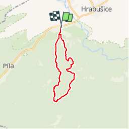

Lengte
10,1 km

Max. hoogte
962 m

Positief hoogteverschil
449 m
Km-Effort
16,1 km

Min. hoogte
542 m

Negatief hoogteverschil
444 m
Boucle
Ja
Datum van aanmaak :
2019-01-15 13:15:50.699
Laatste wijziging :
2019-01-15 13:15:50.699
3h18
Moeilijkheid : Moeilijk

Gratisgps-wandelapplicatie
 SityTrail
IGN / Geografische instituten
SityTrail World
De wereld gaat voor u open
Over ons
Tocht Stappen van 10,1 km beschikbaar op Košický kraj, Onbekend, okres Spišská Nová Ves. Deze tocht wordt voorgesteld door sit68000.
Plaatsbepaling
Land:
Slovakia
Regio :
Košický kraj
Departement/Provincie :
Onbekend
Gemeente :
okres Spišská Nová Ves
Locatie:
Hrabušice
Vertrek:(Dec)
Vertrek:(UTM)
455051 ; 5423940 (34U) N.
Opmerkingen
Wandeltochten in de omgeving