Tocht Mountainbike Ribeauvillé - Ribeauvillé - Col de Seelacker - Photo

Ribeauvillé - Col de Seelacker

 tracegps
tracegps

Gebruiker

© OpenStreetMap contributors
Lengte
Lengte
29 km
Max. hoogte
Max. hoogte
787 m
Positief hoogteverschil
936 m
Km-Effort
Km-Effort  
42 km
Min. hoogte
Min. hoogte
234 m
Negatief hoogteverschil
935 m
Boucle
Boucle
Ja
Datum van aanmaak :
2014-12-10 00:00:00.0
Laatste wijziging :
2014-12-10 00:00:00.0

(0 Bericht)

Mountainbike
Mountainbike
2h30
Moeilijkheid : Zeer moeilijk

Scan deze QR-code om de tocht te openen in de SityTrail-applicatie

Gratisgps-wandelapplicatie

Logo SityTrail SityTrail

IGN / Geografische instituten

SityTrail uit de App Store downloaden SityTrail uit Google Play downloaden

Logo SityTrail SityTrail World

De wereld gaat voor u open

SityTrail uit de App Store downloaden SityTrail uit Google Play downloaden SityTrail op Huawei AppGallery downloaden

Over ons

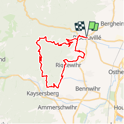
Tocht Mountainbike van 29 km beschikbaar op Grand Est, Haut-Rhin, Ribeauvillé. Deze tocht wordt voorgesteld door tracegps.

Beschrijving

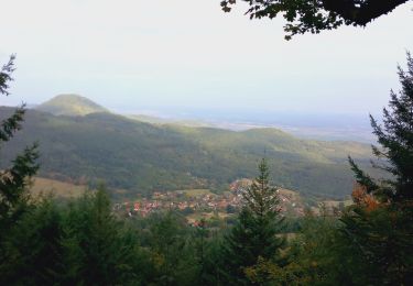
oli circuit entre Vosges et vignoble. La seule difficulté est la longue montée vers le col de Seelacker et le Sapins des français sur des chemins carrossables. La descente entre la chapelle St Alexis et Toggenbach est tellement plane ( route récemment refaite sans doute ) que vous pouvez en profiter pour lire le journal... La suite des aventures est ICI

Hoogteprofiel

Foto's

Plaatsbepaling

Land:
France
Regio :
Grand Est
Departement/Provincie :
Haut-Rhin
Gemeente :
Ribeauvillé
Locatie:
Unknown
Vertrek:(Dec)
Vertrek:(UTM)
375502 ; 5339052 (32U) N.

Wandeltochten in de omgeving

Tocht Mountainbike Ribeauvillé - Ribeauvillé Riquewihr - Photo
Mountainbike
tracegps

Mountainbike

Medium
(1)
Ribeauvillé, Grand Est, Haut-Rhin, France
19,3 km | 24 km-effort
1h 30min
Ja
Tocht Stappen Ribeauvillé - 2023-08-26 Marche Ribeauville Taennchel - Photo
Stappen
GUIDE
holtzv

Stappen

Medium
(1)
Ribeauvillé, Grand Est, Haut-Rhin, France
20 km | 34 km-effort
7h 45min
Ja
Tocht Stappen Hunawihr - Hunawihr - Riquewihr - Photo
Stappen
JMCMoreau

Stappen

Gemakkelijk
(1)
Hunawihr, Grand Est, Haut-Rhin, France
6,3 km | 9 km-effort
2h 15min
Ja
Tocht Stappen Riquewihr - Sentier des grands crus - Photo
Stappen
GUIDE
pascalou73

Stappen

Medium
(2)
Riquewihr, Grand Est, Haut-Rhin, France
11,5 km | 14,4 km-effort
3h 7min
Ja
Tocht Stappen Saint-Hippolyte - St hippolyte ht koenigsbourg - Photo
Stappen
legereric

Stappen

Medium
(2)
Saint-Hippolyte, Grand Est, Haut-Rhin, France
12 km | 18,7 km-effort
3h 27min
Ja
Tocht Stappen Saint-Hippolyte - St-Hippolyte - Rorschwihr - Grasberg - Bergheim - Reichenberg - Rodern - Photo
Stappen
VacheKiri67

Stappen

Medium
Saint-Hippolyte, Grand Est, Haut-Rhin, France
17,3 km | 22 km-effort
4h 28min
Ja
Tocht Stappen Mittelwihr - Mittelwihr - Beblenheim - Zellenberg - Hunawihr  - Riquewihr -  Nécropole de Sigolsheim - Photo
Stappen
VacheKiri67

Stappen

Medium
Mittelwihr, Grand Est, Haut-Rhin, France
14,5 km | 19,3 km-effort
4h 8min
Ja
Tocht Mountainbike Bergheim - 1 ère sortie - Photo
Mountainbike
Jeje Seuil

Mountainbike

Gemakkelijk
Bergheim, Grand Est, Haut-Rhin, France
12,6 km | 19,1 km-effort
1h 53min
Ja
Tocht Stappen Riquewihr - Riquewihr  - Photo
Stappen
ISATR

Stappen

Medium
Riquewihr, Grand Est, Haut-Rhin, France
13,8 km | 18,2 km-effort
4h 8min
Ja


Sluiten
Mijn abonnementen