![](/images/other/stat-length.png)
![Tocht Stappen Granville - Granville - Haute ville - tour des remparts - Photo](https://media.geolcdn.com/t/1900/400/ext.pjpeg?maxdim=2&url=https%3A%2F%2Fstatic1.geolcdn.com%2Fsiteimages%2Fupload%2Ffiles%2F1553511878bg_sport_marche.png)
Granville - Haute ville - tour des remparts
toporient
Gebruiker
![Lengte](/images/other/stat-length.png)
Lengte
3,1 km
![Max. hoogte](https://static1.geolcdn.com/siteimages/upload/files/1508320355ic_sort_altitude_max_24dp.png)
Max. hoogte
43 m
![Positief hoogteverschil](https://static1.geolcdn.com/siteimages/upload/files/1508320355ic_sort_den_pos_24dp.png)
Positief hoogteverschil
57 m
![Km-Effort](/images/other/stat-length.png)
Km-Effort
3,8 km
![Min. hoogte](https://static1.geolcdn.com/siteimages/upload/files/1508320355ic_sort_altitude_min_24dp.png)
Min. hoogte
14 m
![Negatief hoogteverschil](https://static1.geolcdn.com/siteimages/upload/files/1508320355ic_sort_den_neg_24dp.png)
Negatief hoogteverschil
62 m
![Boucle](https://static1.geolcdn.com/siteimages/upload/files/16400158638029165_repeat_loop_refresh_sync_direction_icon.png)
Boucle
Ja
Datum van aanmaak :
2019-01-15 14:08:42.225
Laatste wijziging :
2019-01-15 14:08:42.225
![Stappen](https://static1.geolcdn.com/sitytour/trail-icons/101.png)
50m
Moeilijkheid : Heel gemakkelijk
![Scan deze QR-code om de tocht te openen in de SityTrail-applicatie](https://capi.geolives.com/qq0zvz2zws4bq2lad0pu/sitytour/trails/1016678/qr.png?size=200)
Gratisgps-wandelapplicatie
Over ons
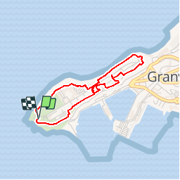
Tocht Stappen van 3,1 km beschikbaar op Normandië, Manche, Granville. Deze tocht wordt voorgesteld door toporient.
Beschrijving
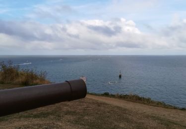
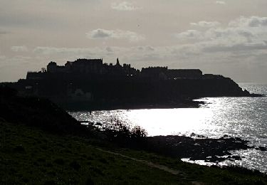
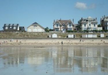
En ville haute, départ du phare de la Pointe du Roc. Suivre le balisage "chemin du littoral" (attention: la partie exposée au sud du phare est actuellement fermée, suivre la déviation qui passe à l'est de celui-ci.)
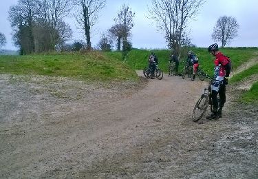
Plaatsbepaling
Land:
France
Regio :
Normandië
Departement/Provincie :
Manche
Gemeente :
Granville
Locatie:
Unknown
Vertrek:(Dec)
Vertrek:(UTM)
601816 ; 5409954 (30U) N.
Opmerkingen
Wandeltochten in de omgeving
![Tocht Mountainbike Yquelon - La Maximum VTT - Granville - Photo](https://media.geolcdn.com/t/375/260/ext.jpg?maxdim=2&url=https%3A%2F%2Fservices.sitytrail.com%2FGeolivesWS%2FDownloadMedia.ashx%3FTrailID%3D317696%26Media%3D16990_4.jpg)
![Mountainbike Mountainbike](https://static1.geolcdn.com/sitytour/trail-icons/202.png)
La Maximum VTT - Granville
Mountainbike
Moeilijk
(1)
Yquelon,
Normandië,
Manche,
France
![](/images/other/stat-length.png)
51 km | 61 km-effort
3h 19min
![](https://static1.geolcdn.com/siteimages/upload/files/16400158638029165_repeat_loop_refresh_sync_direction_icon.png)
Ja
![Tocht Mountainbike Donville-les-Bains - 50-vtt-donville-21km-200m - Photo](https://media.geolcdn.com/t/375/260/ext.jpg?maxdim=2&url=https%3A%2F%2Fmedia.geolcdn.com%2Ff%2F1780a610-d28f-4f7f-bdad-d32483604bd0.jpg)
![Mountainbike Mountainbike](https://static1.geolcdn.com/sitytour/trail-icons/202.png)
50-vtt-donville-21km-200m
Mountainbike
Medium
Donville-les-Bains,
Normandië,
Manche,
France
![](/images/other/stat-length.png)
21 km | 24 km-effort
1h 39min
![](https://static1.geolcdn.com/siteimages/upload/files/16400158638029165_repeat_loop_refresh_sync_direction_icon.png)
Ja
![Tocht Mountainbike Donville-les-Bains - 50-vtt-donville-28km - Photo](https://media.geolcdn.com/t/375/260/ext.jpg?maxdim=2&url=https%3A%2F%2Fmedia.geolcdn.com%2Ff%2F283ae410-e7da-45fb-9b33-aeccc3fd5afc.jpg)
![Mountainbike Mountainbike](https://static1.geolcdn.com/sitytour/trail-icons/202.png)
50-vtt-donville-28km
Mountainbike
Medium
Donville-les-Bains,
Normandië,
Manche,
France
![](/images/other/stat-length.png)
28 km | 31 km-effort
2h 7min
![](https://static1.geolcdn.com/siteimages/upload/files/16400158638029165_repeat_loop_refresh_sync_direction_icon.png)
Ja
![Tocht Noords wandelen Granville - GranvIlle Cap Lihou - Photo](https://media.geolcdn.com/t/375/260/ext.jpg?maxdim=2&url=https%3A%2F%2Fmedia.geolcdn.com%2Ff%2Fc269533b-8b6f-485d-8c50-20bd82f17d1c.jpg)
![Noords wandelen Noords wandelen](https://static1.geolcdn.com/sitytour/trail-icons/102.png)
GranvIlle Cap Lihou
Noords wandelen
Medium
Granville,
Normandië,
Manche,
France
![](/images/other/stat-length.png)
7 km | 8,2 km-effort
1h 7min
![](https://static1.geolcdn.com/siteimages/upload/files/16400158638029165_repeat_loop_refresh_sync_direction_icon.png)
Ja
![Tocht Stappen Donville-les-Bains - Donville Granville - Photo](https://media.geolcdn.com/t/375/260/ext.jpg?maxdim=2&url=https%3A%2F%2Fservices.sitytrail.com%2FGeolivesWS%2FDownloadMedia.ashx%3FTrailID%3D704938%26Media%3Dfix__20170225162805.jpg)
![Stappen Stappen](https://static1.geolcdn.com/sitytour/trail-icons/101.png)
Donville Granville
Stappen
Gemakkelijk
Donville-les-Bains,
Normandië,
Manche,
France
![](/images/other/stat-length.png)
5,8 km | 7,6 km-effort
1h 31min
![](https://static1.geolcdn.com/siteimages/upload/files/16400158638029165_repeat_loop_refresh_sync_direction_icon.png)
Neen
![Tocht Stappen Donville-les-Bains - BALANCE SUR LES PLAGES DE BREVILLE - Photo](https://media.geolcdn.com/t/375/260/ext.jpg?maxdim=2&url=https%3A%2F%2Fservices.sitytrail.com%2FGeolivesWS%2FDownloadMedia.ashx%3FTrailID%3D415348%26Media%3D20150502112556.jpg)
![Stappen Stappen](https://static1.geolcdn.com/sitytour/trail-icons/101.png)
BALANCE SUR LES PLAGES DE BREVILLE
Stappen
Heel gemakkelijk
Donville-les-Bains,
Normandië,
Manche,
France
![](/images/other/stat-length.png)
18,3 km | 19,6 km-effort
4h 40min
![](https://static1.geolcdn.com/siteimages/upload/files/16400158638029165_repeat_loop_refresh_sync_direction_icon.png)
Ja
![Tocht Stappen Bréville-sur-Mer - Balade à Breville sur Mer - Photo](https://media.geolcdn.com/t/375/260/ext.jpg?maxdim=2&url=https%3A%2F%2Fservices.sitytrail.com%2FGeolivesWS%2FDownloadMedia.ashx%3FTrailID%3D172624%26Media%3D13990_6.jpg)
![Stappen Stappen](https://static1.geolcdn.com/sitytour/trail-icons/101.png)
Balade à Breville sur Mer
Stappen
Medium
Bréville-sur-Mer,
Normandië,
Manche,
France
![](/images/other/stat-length.png)
14,2 km | 15,4 km-effort
3h 0min
![](https://static1.geolcdn.com/siteimages/upload/files/16400158638029165_repeat_loop_refresh_sync_direction_icon.png)
Ja
![Tocht Stappen Granville - Les chemins de Saint Michel - Granville - Avranches - Photo](https://media.geolcdn.com/t/375/260/ext.jpg?maxdim=2&url=https%3A%2F%2Fservices.sitytrail.com%2FGeolivesWS%2FDownloadMedia.ashx%3FTrailID%3D112749%26Media%3D11880_3.jpg)
![Stappen Stappen](https://static1.geolcdn.com/sitytour/trail-icons/101.png)
Les chemins de Saint Michel - Granville - Avranches
Stappen
Medium
Granville,
Normandië,
Manche,
France
![](/images/other/stat-length.png)
45 km | 52 km-effort
Onbekend
![](https://static1.geolcdn.com/siteimages/upload/files/16400158638029165_repeat_loop_refresh_sync_direction_icon.png)
Neen
![Tocht Stappen Granville - De Granville a Hauteville - Photo](https://media.geolcdn.com/t/375/260/ext.jpg?maxdim=2&url=https%3A%2F%2Fservices.sitytrail.com%2FGeolivesWS%2FDownloadMedia.ashx%3FTrailID%3D70771%26Media%3De496b1f3-9f1c-467d-8a8d-dc8211f0773f.JPG)
![Stappen Stappen](https://static1.geolcdn.com/sitytour/trail-icons/101.png)
De Granville a Hauteville
Stappen
Medium
Granville,
Normandië,
Manche,
France
![](/images/other/stat-length.png)
42 km | 46 km-effort
Onbekend
![](https://static1.geolcdn.com/siteimages/upload/files/16400158638029165_repeat_loop_refresh_sync_direction_icon.png)
Neen