Tocht Stappen Sainte-Foy-de-Peyrolières - Autour de Ste Foy de Peyrolières - Photo

Autour de Ste Foy de Peyrolières

 tracegps
tracegps

Gebruiker

© OpenStreetMap contributors
Lengte
Lengte
9,4 km
Max. hoogte
Max. hoogte
270 m
Positief hoogteverschil
149 m
Km-Effort
Km-Effort  
11,4 km
Min. hoogte
Min. hoogte
220 m
Negatief hoogteverschil
149 m
Boucle
Boucle
Ja
Datum van aanmaak :
2014-12-10 00:00:00.0
Laatste wijziging :
2014-12-10 00:00:00.0

(0 Bericht)

Stappen
Stappen
3h00
Moeilijkheid : Medium

Scan deze QR-code om de tocht te openen in de SityTrail-applicatie

Gratisgps-wandelapplicatie

Logo SityTrail SityTrail

IGN / Geografische instituten

SityTrail uit de App Store downloaden SityTrail uit Google Play downloaden

Logo SityTrail SityTrail World

De wereld gaat voor u open

SityTrail uit de App Store downloaden SityTrail uit Google Play downloaden SityTrail op Huawei AppGallery downloaden

Over ons

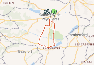
Tocht Stappen van 9,4 km beschikbaar op Occitanië, Haute-Garonne, Sainte-Foy-de-Peyrolières. Deze tocht wordt voorgesteld door tracegps.

Beschrijving

Circuit très simple de début de saison :-). Départ derrière la poste de Ste Foy. Circuit sympa de l'après-midi proposé le 16 Septembre 2008 par l'association AILE de Cugnaux, 16 participants.

Hoogteprofiel

Plaatsbepaling

Land:
France
Regio :
Occitanië
Departement/Provincie :
Haute-Garonne
Gemeente :
Sainte-Foy-de-Peyrolières
Locatie:
Unknown
Vertrek:(Dec)
Vertrek:(UTM)
350031 ; 4817123 (31T) N.

Wandeltochten in de omgeving

Tocht Stappen Saiguède - Raide de Saiguède - Photo
Stappen
tracegps

Stappen

Moeilijk
(1)
Saiguède, Occitanië, Haute-Garonne, France
19 km | 23 km-effort
4h 0min
Ja
Tocht Stappen Sainte-Foy-de-Peyrolières - RANDO-Ste Foy Téléthon 2012 - Photo
Stappen
Polo-31

Stappen

Gemakkelijk
Sainte-Foy-de-Peyrolières, Occitanië, Haute-Garonne, France
8 km | 9,3 km-effort
2h 2min
Ja
Tocht Stappen Sainte-Foy-de-Peyrolières - Lac et bois autour de Sainte Foy de Peyrolières - Photo
Stappen
tracegps

Stappen

Gemakkelijk
Sainte-Foy-de-Peyrolières, Occitanië, Haute-Garonne, France
9 km | 11,2 km-effort
2h 30min
Ja
Tocht Stappen Sainte-Foy-de-Peyrolières - Ste Foy de Peyrolières 13 Avril 2020 - Photo
Stappen
daniel3157

Stappen

Gemakkelijk
Sainte-Foy-de-Peyrolières, Occitanië, Haute-Garonne, France
16,4 km | 21 km-effort
4h 58min
Ja
Tocht Lopen Saiguède - Raide de Saiguède - Photo
Lopen
tracegps

Lopen

Zeer moeilijk
Saiguède, Occitanië, Haute-Garonne, France
19 km | 23 km-effort
2h 0min
Ja
Tocht Stappen Sainte-Foy-de-Peyrolières - Randonnée Sainte Foy de Peyrolières  - Photo
Stappen
Fafou64

Stappen

Sainte-Foy-de-Peyrolières, Occitanië, Haute-Garonne, France
10,7 km | 12,9 km-effort
2h 39min
Ja
Tocht Stappen Saiguède - Saiguède belles vues - Photo
Stappen
pidjam

Stappen

Heel gemakkelijk
Saiguède, Occitanië, Haute-Garonne, France
8,3 km | 10,5 km-effort
2h 0min
Ja
Tocht Stappen Empeaux - Empeaux circuit cross - Photo
Stappen
pidjam

Stappen

Gemakkelijk
Empeaux, Occitanië, Haute-Garonne, France
9,7 km | 12,5 km-effort
2h 40min
Ja
Tocht Fiets Sainte-Foy-de-Peyrolières - V003-Tour LASSERRE - Photo
Fiets
Polo-31

Fiets

Moeilijk
Sainte-Foy-de-Peyrolières, Occitanië, Haute-Garonne, France
141 km | 163 km-effort
6h 0min
Ja


Sluiten
Mijn abonnementen