Autour de Gabarret
tracegps
Gebruiker
Lengte
29 km
Max. hoogte
184 m
Positief hoogteverschil
282 m
Km-Effort
33 km
Min. hoogte
116 m
Negatief hoogteverschil
282 m
Boucle
Ja
Datum van aanmaak :
2014-12-10 00:00:00.0
Laatste wijziging :
2014-12-10 00:00:00.0
3h00
Moeilijkheid : Medium
Gratisgps-wandelapplicatie
Over ons
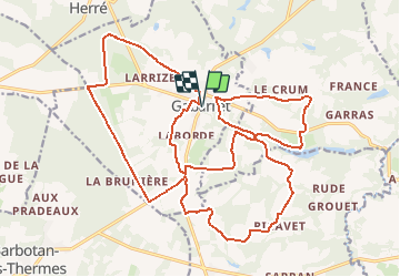
Tocht Mountainbike van 29 km beschikbaar op Nieuw-Aquitanië, Landes, Gabarret. Deze tocht wordt voorgesteld door tracegps.
Beschrijving
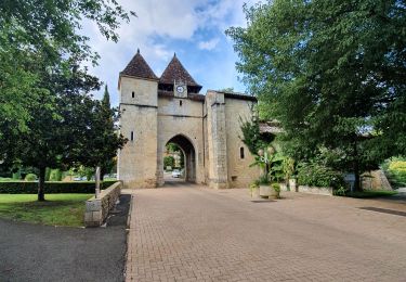
Autour de Gabarret. Intérêt : forêt, collines du Gabardan, architecture traditionnelle. Retrouvez d’autres photos et la description complète sur Ciron VTT, des circuits de randonnées VTT et traces GPS dans la vallée du Ciron (Gironde, Landes) et au-delà …
Plaatsbepaling
Land:
France
Regio :
Nieuw-Aquitanië
Departement/Provincie :
Landes
Gemeente :
Gabarret
Locatie:
Unknown
Vertrek:(Dec)
Vertrek:(UTM)
260283 ; 4874541 (31T) N.
Opmerkingen
Wandeltochten in de omgeving
bardotan ballade
Stappen
Gemakkelijk
(3)
Cazaubon,
Occitanië,
Gers,
France
5,1 km | 6 km-effort
1h 39min
Ja
Boucle Barbotan - Nord Est
Stappen
Heel gemakkelijk
Cazaubon,
Occitanië,
Gers,
France
14,2 km | 15,9 km-effort
3h 5min
Ja
Barbotan " le Loungat"
Stappen
Gemakkelijk
(2)
Cazaubon,
Occitanië,
Gers,
France
5,9 km | 7,2 km-effort
1h 33min
Ja
barbotan Cazaubon 10km
Stappen
Medium
Cazaubon,
Occitanië,
Gers,
France
9,9 km | 11,7 km-effort
3h 12min
Ja
Loungat - L'Uby
Stappen
Gemakkelijk
Cazaubon,
Occitanië,
Gers,
France
15 km | 17,8 km-effort
3h 5min
Ja
Tour du lac de l'Uby par les passerelles
Stappen
Heel gemakkelijk
Cazaubon,
Occitanië,
Gers,
France
7,7 km | 9 km-effort
1h 40min
Ja
barbotan cazaubon
Andere activiteiten
Heel gemakkelijk
Cazaubon,
Occitanië,
Gers,
France
10,4 km | 12,2 km-effort
3h 24min
Ja